Avernas-le-Bauduin No. 2 / Inm'na
Results: 3 records
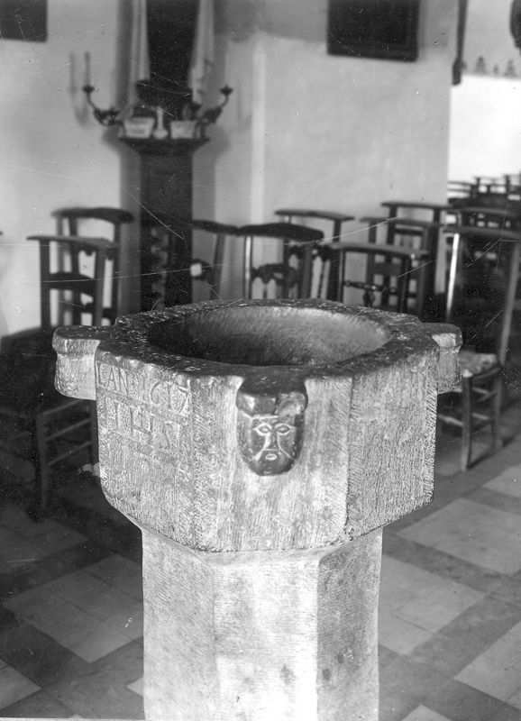
human figure - head - 4
Scene Description: [cf. FontNotes]
inscription
Scene Description: [cf. FontNotes]
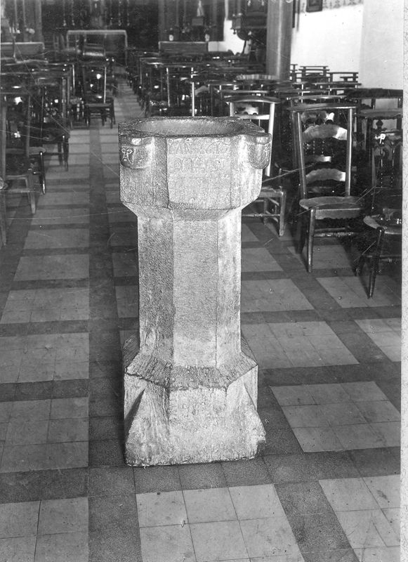
view of stoup
Copyright Statement: Image copyright © KIK-IRPA, Brussels (Belgium), 2026
Image Source: digital image of a 1944 B&W photograph [cliché A069951] by Commissariat général à la Protection aérienne passive
Copyright Instructions: CC-BY-4.0
INFORMATION
Font ID: 26212KKK
Object Type: Stoup
Font Date: 1617
Font Century and Period/Style: 17th century (early)
Workshop/Group/Artisan: Mosan type
Church / Chapel Name: Eglise Notre-Dame de l'Assomption
Font Location in Church: Inside, in the nave
Church Patron Saint(s): The Assumption of St. Mary
Church Notes: original church 11-12thC of which the tower remains; present church 14thC; re-built 17th and 18thC
Church Address: Rue Jean-Pascal Dochen 2-10, 4280 Hannut, Belgium
Site Location: Liège / Luik, Wallonie / Wallonne, Belgium, Europe
Directions to Site: Located off (W) the N80, in the municipality and 3 km N of Hannut
Ecclesiastic Region: Diocèse de Liège / Bistum Lüttich
Town/City Wikipedia: https://fr.wikipedia.org/wiki/Avernas-le-Bauduin
Font Notes:
Click to view
Holy-water stoup dated 1617 by an inscription, listed and illustrated in BALaT KIK-IRPA [https://balat.kikirpa.be/object/10028817] [accessed 12 March 2026]: "bénitier [...] pierre [...] datation, taillé, : : lan 1617 IHS [...] hauteur: 113.5 cm; largeur: 62.5 cm".
A communication to BSI from Pol Herman (e-mail of 3 November 2025) informs: "Avernas-le-Bauduin, église Notre-Dame de l'Assomption.
https://youtu.be/0IUfsUoFgEc + https://youtu.be/OwTxgePG7E0 -- A Christian sanctuary stood in Avernas at least since the ninth century, but its location is unknown. The county of Avernas existed since 950. The oldest known document mentioning the church of Avernas-le-Bauduin dates from 1124. In that year, Wouter van Trudineis (Wautier de Trognée), of the priory Notre-Dame of Bertrée, donated his properties in Evernas Balduini to the Abbey of Cluny. Its location made the region permanently unsafe: plundering, destruction, and arsonery were commonplace during the middle ages. On May 21, 1276, the people of Liège and Haspengouw burned down Landen, Hannut, and 23 villages in the surrounding countryside. On April 24, 1332, Prince-Bishop Adolf II of the Mark ordered his troops to burn Hannut and nine surrounding villages to ashes. In August 1356, Hannut was captured by Liège armies, and the neighboring villages were destroyed. In 1378, Hannut and the surrounding villages were again pillaged and burned. The current church building dates from the 14th century, but the tower with its octagonal roof is largely still part of the original 11th-century construction. The tower is built of flint and limestone. Its medieval appearance and the thickness of its walls attest that it was originally a fortified structure, closed at its base, probably built in the 11th or 12th century and used as a refuge for the villagers in case of hostilities. The tower had already been restored in the 14th century. In 1465 the village was burned down again by troops from Liège and again years of misery followed for the inhabitants. Avernas initially belonged to the diocese of Liège. In 1559, the parish, along with the dependent chapels of Cras-Avernas and Bertrée, was annexed to the diocese of Namur. For a very long time, the parish was administered by monks from the Abbey of St. Lawrence in Liège. It was not until 1616 that Nicolas Moreau was appointed by the abbot of St. Lawrence as the first secular pastor of Avernas. Rebuilt in 1671: consecration of the church to Our Lady of the Assumption. The church was partially rebuilt under the pastorate of Claude Rochette (1720-1757).
1768: again partial restoration and reconstruction. Baptismal font. https://balat.kikirpa.be/object/10028817
Octagonal, limestone, Mosan stoup with four crude heads and the date 1617 inscribed. Probably installed when first secular priest was appointed.
https://balat.kikirpa.be/object/10028818 -- Limestone baptismal font from the end of the 17th c."
Credit and Acknowledgements: We are grateful to Pol Herman for bringing this font to our attention and for his help documenting it
COORDINATES
Latitude & Longitude (Decimal): 50.69438, 5.07859
Latitude & Longitude (DMS): 50° 41′ 28″ N, 5° 04′ 38″ E
MEDIUM AND MEASUREMENTS
Material: stone, limestone
Font Shape: octagonal (mounted)
Basin Interior Shape: round
Basin Exterior Shape: octagonal
Diameter (includes rim): 62.5 cm*
Font Height (less Plinth): 113.5 cm*
Notes on Measurements: * [cf. FontNotes]
INSCRIPTION
Inscription Language: letters & numbers
Inscription Location: on the basin side
Inscription Text: "lan 1617 / IHS"
Inscription Notes: [cf. FontNotes]
Inscription Source: [cf. FontNotes]
REFERENCES
- KIK-IRPA, BALaT KIK-IRPA, 2024. URL: https://balat.kikirpa.be/.