Grand Hallet / Grand-Halle / Grand-Hallez / Grant-Hallay / Grant-Hallez / Groot-Halleer / Haleh / Halei / Halleer / Hallei / Halleo magno / Hallerium / Hallerte / Halley / Halley-le-Grand / Halleys / Hathlei / magnum Haleir
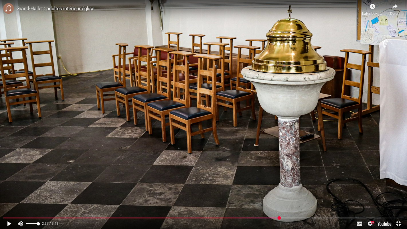
Image copyright © Les Murs de Pierre, 2026
Standing permission
Results: 4 records
view of font and cover in context
Scene Description: the modern, mid-19thC font
Copyright Statement: Image copyright © Les Murs de Pierre, 2026
Image Source: digital photograph by Les Murs de Pierre
Copyright Instructions: Standing permission
view of font and cover in context
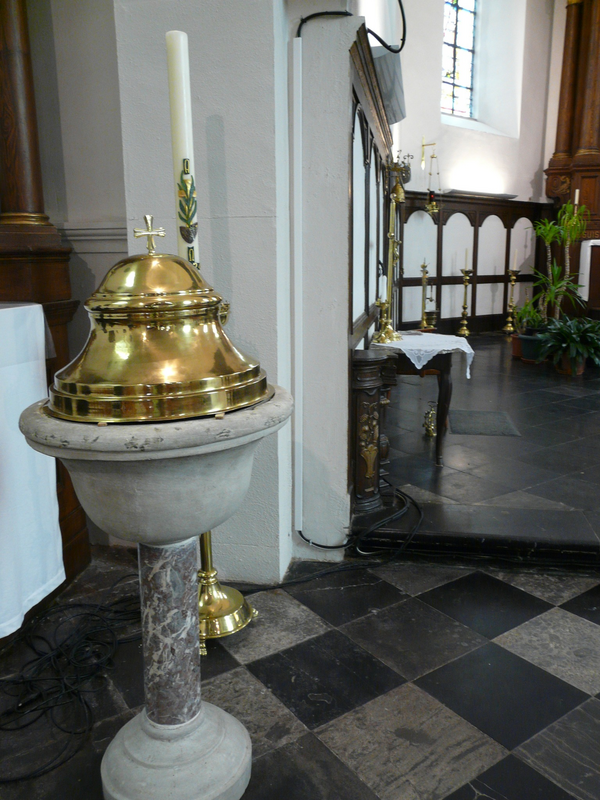
Scene Description: the modern, mid-19thC font
Copyright Statement: Image copyright © Les Murs de Pierre, 2026
Image Source: digital photograph by Les Murs de Pierre
Copyright Instructions: Standing permission
view of font and cover
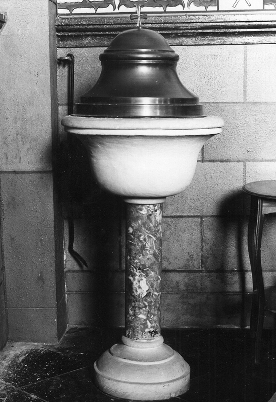
Scene Description: the modern, mid-19thC font
Copyright Statement: Image copyright © KIK-IRPA, Brussels (Belgium), 2026
Image Source: digital image of a 1968 B&W photograph [cliché M027784] by Mahaux, Charles, IRPA
Copyright Instructions: CC-BY-4.0
view of church exterior - southwest view
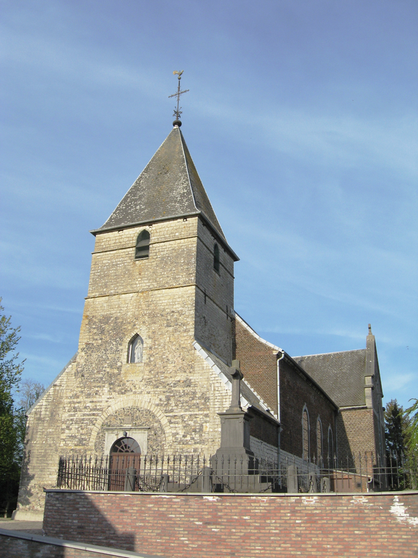
Scene Description: "Sint-Blasius in Grand-Hallet / Eglise Saint-Blaise à Grand-Hallet / Church of Saint Blaise in Grand-Hallet, Hannut, Liège, Belgium"
Copyright Statement: Image copyright © Sonuwe, 2008
Image Source: digital photograph 4 May 2008 by Sonuwe
Copyright Instructions: GFDL
INFORMATION
Font ID: 26181UPP
Object Type: Baptismal Font1?
Font Century and Period/Style: 12th - 13th century (?), Medieval?
Church / Chapel Name: Eglise Saint-Blaise
Font Location in Church: disappeared?
Church Patron Saint(s): St. Blaise
Church Notes: [cf. FontNotes]
Church Address: Rue René Detiste 20, 4280 Hannut, Belgium
Site Location: Liège / Luik, Wallonie / Wallonne, Belgium, Europe
Directions to Site: Located off (N) the N240, E of the N64, in the municipality and 5-6 km NNE of Hannut, 35-40 km NE of Namur
Ecclesiastic Region: Diocèse de Liège / Bistum Lüttich
Additional Comments: disappeared font? (the one from the medieval church here)
Town/City Wikipedia: https://fr.wikipedia.org/wiki/Grand-Hallet
Font Notes:
Click to view
The present font in this church is modern, mid-19th century; listed and illustrated in BALaT KIK-IRPA [https://balat.kikirpa.be/object/10029871] [accessed 3 March 2026]: "fonts baptismaux [...] Date: 1841 - 1860".
A communication to BSI from Pol Herman (e-mail of 14 February 2026): "Grand-Hallet, église Saint-Blaise. Groot-Halleer. 1016 Haleh, 1116 Hallei, 1136 Halley, 1194-1229 Hathlei, 1223 Halleer, 1228 Halleys, 1244 Halei, 1350 Halleo magno, 1369 magnum Haleir, 1375 : Halley-le-Grand, 1468 Grand-Halle, 1617 Hallerte, 1619 Haller le Grand, 1664 Hallar-le-Grand, 18e s. Hallerium, Grand-Hallez, Grant-Hallez, Grant-Hallay. The centre of the present village was already occupied in Roman times, as demonstrated by the discovery of several villas. Tower and lordship : From the 9th century onwards, the village of Hallet (probably Petit- and Grand- together) was part of the county of Avernas. Besides the fortified church tower, there was another defensive tower in the village, that was first mentioned in 1323 as “la tour de Hallet” owned by Ernoul Carpéal. It was integrated in the “château-ferme“ of the lords of Grand-Hallet in the 17th century. It was demolished in 1835. Workers had set up a mine to blow it up and were withdrawing, but some village children lit the fuse prematurely and the tower collapsed, injuring several people. The church: The first place of worship is believed to have been built towards the end of the 8th century. It was a modest wooden chapel that stood on the site of the present-day church. In the years that followed, banditry and feudal wars quickly destroyed this structure. It was not until the 11th century that stone was used for its reconstruction. The first known written mention of the village dates from 1116, in the form of "Hallei". The church was first mentioned in 1139 as belonging to the deanery of Jodoigne. Its name appears as a parish required to offer sacrifices and participate in the processions of the “croix banales” of Sint-Truiden. 1201-1210: a new church in the Romanesque style, of which only the tower still exists. The tower also served for the defense of the inhabitants and had only one entrance from within the church itself. Compared to today, its nave was located on the other side of the tower. In the 13th century, all churches in the region belonged to the cathedrals and abbeys of Liège, which held patronage rights over them. For the church of Grand-Hallet, these rights were shared between the chapter of the Cathedral of Saint Lambert in Liège and the Abbey of the Maagdendal (Val des Vierges) in Oplinter until 1228/1229. After that, both ceded their rights, with the exception of tithes, to the collegiate church of Saint Bartholomew of Liège. 1348: Theft of liturgical objects from the church. 1465: Major destruction by troops of the Prince-Bishopric of Liège. 1673/1674: Church ransacked by troops of the Spanish/German/Dutch alliance. 1676: Church completely dilapidated after another Dutch troop invasion. Reconsecrated in 1681. 1697: The country is deserted and depopulated by wars and disease. 1755/1756 several earthquakes and damage to the church. 1758: Construction of a new church granted by the Saint Bartholomew chapter of Liège. Finished in 1762. The nave now stands on the other side of the tower. 1762 : the old church is demolished. 1828 : earthquakes damage the church. 1890-1891: construction of a neoclassical transept and choir. Baptismal records start in 1660. The present marble baptismal font was donated by the noble family of priest Lambert Hubert Pierco around 1850. https://balat.kikirpa.be/object/10029871 -- Pictures by Les Murs de Pierre"
A communication to BSI from Pol Herman (e-mail of 14 February 2026): "Grand-Hallet, église Saint-Blaise. Groot-Halleer. 1016 Haleh, 1116 Hallei, 1136 Halley, 1194-1229 Hathlei, 1223 Halleer, 1228 Halleys, 1244 Halei, 1350 Halleo magno, 1369 magnum Haleir, 1375 : Halley-le-Grand, 1468 Grand-Halle, 1617 Hallerte, 1619 Haller le Grand, 1664 Hallar-le-Grand, 18e s. Hallerium, Grand-Hallez, Grant-Hallez, Grant-Hallay. The centre of the present village was already occupied in Roman times, as demonstrated by the discovery of several villas. Tower and lordship : From the 9th century onwards, the village of Hallet (probably Petit- and Grand- together) was part of the county of Avernas. Besides the fortified church tower, there was another defensive tower in the village, that was first mentioned in 1323 as “la tour de Hallet” owned by Ernoul Carpéal. It was integrated in the “château-ferme“ of the lords of Grand-Hallet in the 17th century. It was demolished in 1835. Workers had set up a mine to blow it up and were withdrawing, but some village children lit the fuse prematurely and the tower collapsed, injuring several people. The church: The first place of worship is believed to have been built towards the end of the 8th century. It was a modest wooden chapel that stood on the site of the present-day church. In the years that followed, banditry and feudal wars quickly destroyed this structure. It was not until the 11th century that stone was used for its reconstruction. The first known written mention of the village dates from 1116, in the form of "Hallei". The church was first mentioned in 1139 as belonging to the deanery of Jodoigne. Its name appears as a parish required to offer sacrifices and participate in the processions of the “croix banales” of Sint-Truiden. 1201-1210: a new church in the Romanesque style, of which only the tower still exists. The tower also served for the defense of the inhabitants and had only one entrance from within the church itself. Compared to today, its nave was located on the other side of the tower. In the 13th century, all churches in the region belonged to the cathedrals and abbeys of Liège, which held patronage rights over them. For the church of Grand-Hallet, these rights were shared between the chapter of the Cathedral of Saint Lambert in Liège and the Abbey of the Maagdendal (Val des Vierges) in Oplinter until 1228/1229. After that, both ceded their rights, with the exception of tithes, to the collegiate church of Saint Bartholomew of Liège. 1348: Theft of liturgical objects from the church. 1465: Major destruction by troops of the Prince-Bishopric of Liège. 1673/1674: Church ransacked by troops of the Spanish/German/Dutch alliance. 1676: Church completely dilapidated after another Dutch troop invasion. Reconsecrated in 1681. 1697: The country is deserted and depopulated by wars and disease. 1755/1756 several earthquakes and damage to the church. 1758: Construction of a new church granted by the Saint Bartholomew chapter of Liège. Finished in 1762. The nave now stands on the other side of the tower. 1762 : the old church is demolished. 1828 : earthquakes damage the church. 1890-1891: construction of a neoclassical transept and choir. Baptismal records start in 1660. The present marble baptismal font was donated by the noble family of priest Lambert Hubert Pierco around 1850. https://balat.kikirpa.be/object/10029871 -- Pictures by Les Murs de Pierre"
Credit and Acknowledgements: We are grateful to Pol Herman for bringing this font to our attention and for his help documenting it. We are also grateful to Les Murs de Pierre for the photographs of this font
COORDINATES
Latitude & Longitude (Decimal): 50.69416, 5.034639
Latitude & Longitude (DMS): 50° 41′ 38.98″ N, 5° 2′ 4.7″ E
REFERENCES
- KIK-IRPA, BALaT KIK-IRPA, 2024. URL: https://balat.kikirpa.be/.