Boelhe / Beul / Boëlhe / Boëlhe-sur-Geer / Boiel / Boilhe / Boillhez / Boillie / Bolgh deleis Fresin Boye / Bôye
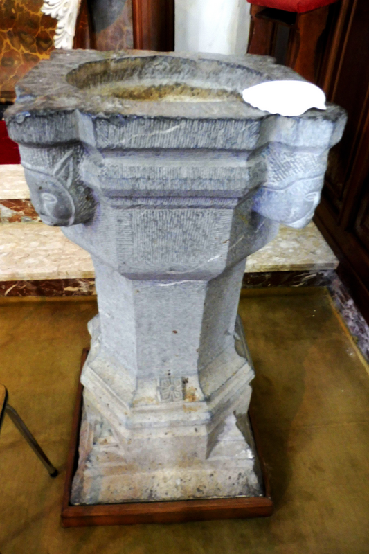
Image copyright © Les Murs de Pierre, 2026
Standing permission
Results: 11 records
view of font or stoup
Scene Description: [cf. FontNotes]
Copyright Statement: Image copyright © Les Murs de Pierre, 2026
Image Source: digital photograph by Les Murs de Pierre
Copyright Instructions: Standing permission
view of font - upper view
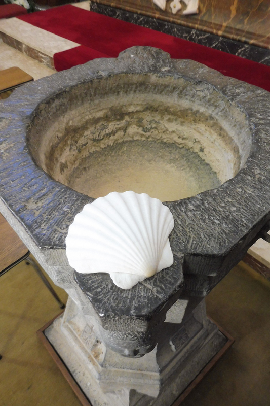
Copyright Statement: Image copyright © Les Murs de Pierre, 2026
Image Source: digital photograph by Les Murs de Pierre
Copyright Instructions: Standing permission
view of font or stoup
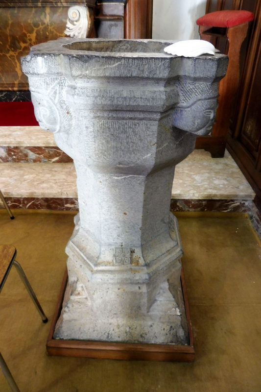
Copyright Statement: Image copyright © Les Murs de Pierre, 2026
Image Source: digital photograph by Les Murs de Pierre
Copyright Instructions: Standing permission
view of font or stoup
![[cf. FontNotes]](/static-50478a99ec6f36a15d6234548c59f63da52304e5/compressed/1260302012_compressed.png)
Scene Description: [cf. FontNotes]
Copyright Statement: Image copyright © KIK-IRPA, Brussels (Belgium), 2026
Image Source: digital image of a 1944 B&W photograph [cliché A069772] by the Commissariat général à la Protection aérienne passive
Copyright Instructions: CC-BY-4.0
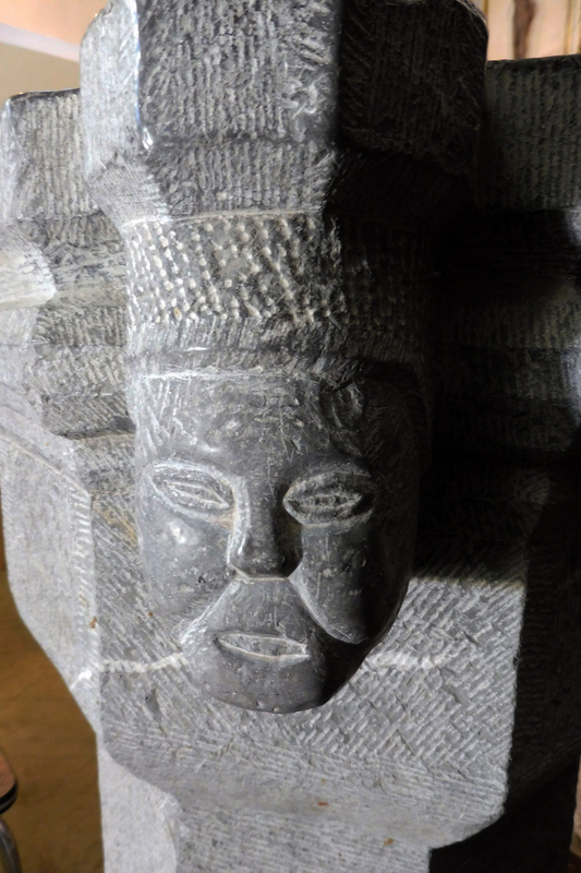
human figure - head
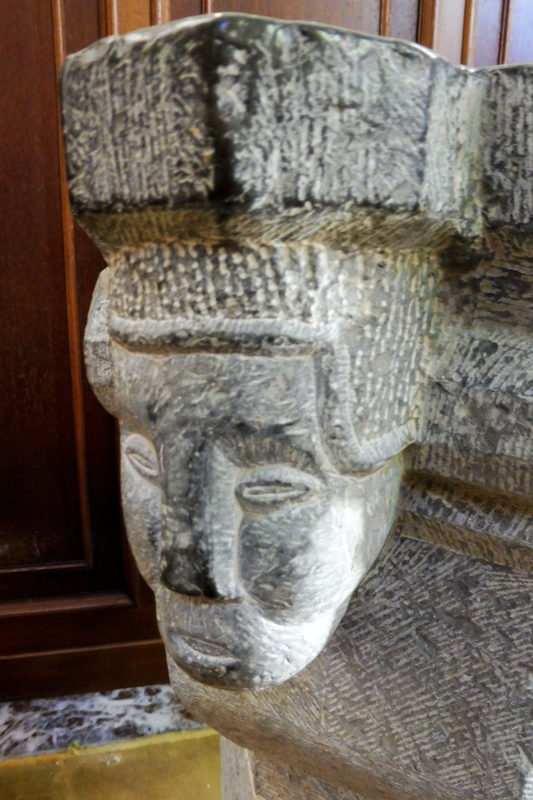
Scene Description: one of four
Copyright Statement: Image copyright © Les Murs de Pierre, 2026
Image Source: digital photograph by Les Murs de Pierre
Copyright Instructions: Standing permission
human figure - head
Scene Description: one of four
Copyright Statement: Image copyright © Les Murs de Pierre, 2026
Image Source: digital photograph by Les Murs de Pierre
Copyright Instructions: Standing permission
human figure - head - 4
Scene Description: [cf. FontNotes]
Copyright Statement: Image copyright © KIK-IRPA, Brussels (Belgium), 2026
Image Source: digital image of a 1944 B&W photograph [cliché A069772] by the Commissariat général à la Protection aérienne passive
Copyright Instructions: CC-BY-4.0
view of church exterior - southwest view
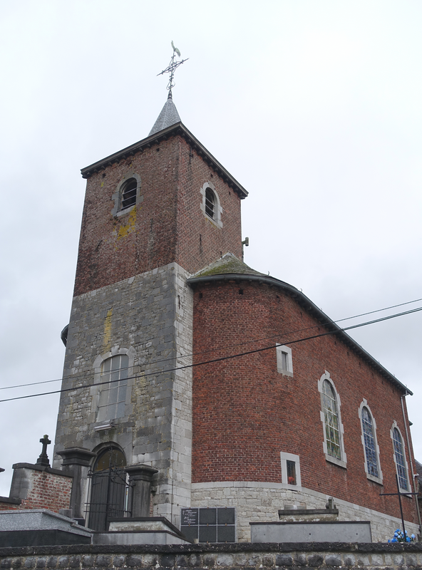
Scene Description: "Eglise Saint-Lambert à Boëlhe (Geer)"
Copyright Statement: Image copyright © Eebie, 2020
Image Source: digital photograph 16 November 2020 by Eebie
Copyright Instructions: CC-BY-SA-4.0
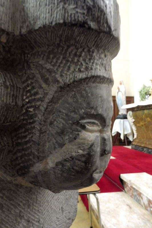
human figure - head
Scene Description: one of four
Copyright Statement: Image copyright © Les Murs de Pierre, 2026
Image Source: digital photograph by Les Murs de Pierre
Copyright Instructions: Standing permission
human figure - head
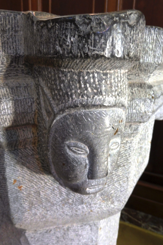
Scene Description: one of four
Copyright Statement: Image copyright © Les Murs de Pierre, 2026
Image Source: digital photograph by Les Murs de Pierre
Copyright Instructions: Standing permission
design element - motifs - stop - 4
Copyright Statement: Image copyright © KIK-IRPA, Brussels (Belgium), 2026
Image Source: digital image of a 1944 B&W photograph [cliché A069772] by the Commissariat général à la Protection aérienne passive
Copyright Instructions: CC-BY-4.0
INFORMATION
Font ID: 26177UOO
Object Type: Baptismal Font1
Cognate Fonts: [cf. FontNotes]
Church / Chapel Name: Eglise Saint-Lambert à Boëlhe
Font Location in Church: Inside
Church Patron Saint(s): St. Lambertus
Church Address: Rue de l'Église 4250 Boëlhe, Belgique
Site Location: Liège / Luik, Wallonie / Wallonne, Belgium, Europe
Directions to Site: Located off (S) Hwy E40, 7-8 km W of Waremme, about 40 km WNW of Liège
Ecclesiastic Region: Diocèse de Liège / Bistum Lüttich
Additional Comments: re-purposed stoup? (now used as font) [cf. FontNotes]
Town/City Wikipedia: https://fr.wikipedia.org/wiki/Boëlhe
Font Notes:
Click to view
The present font probably an earlier holy-water stoup, is listed and illustrated in BALaT KIK-IRPA [https://balat.kikirpa.be/object/10014497] [accessed 2 March 2026]: "fonts baptismaux [...] pierre [ ...] hauteur: 110 cm [...] Date: 1501 - 1600 [...] tête humaine[ornement]".
A communication to BSI from Pol Herman (e-mail of 1 March 2026) informs: "Boëlhe, église Saint-Lambert. Flemish name : Beul; 1316 Bolgh deleis Fresin, Boillhe, Boilhez, Boiel, Boye, Boillie, Boëlhe-sur-Geer. Little is known about the history of Boëlhe. The Franks occupied the region from the 5th to the 8th centuries and built an estate slightly east of the present-day site of Boëlhe Castle. Excavations have revealed the remains of imposing buildings (in the current castle grounds and east of the church), which were inhabited by lords during the feudal era. Interpretation is difficult (early castle, church, or…) In the middle of the village was a motte (mound), that was levelled before 1863, when an archaeological survey took place unsuccessfully. As early as the 14th century, the seigneury must have belonged to a religious institution, as it had an advocate (a person chosen to protect a locality or church, who in return enjoyed certain seigneurial rights). 1258: donation of land to the Val-Benoît Abbey of Liège “between Saint Mary and Saint Lambert”. This would mean that there was already a place of worship dedicated to Saint Lambert. Saint Mary could have been the church of the lost village of Villereaux, some kilometres to the north of Boëlhe. From 1451 onwards the village was a lordship and fief of the Prince-Bishopric of Liège. For a long time, the right to appoint the pastor was in the hands of the chapter of St. Paul's Church in Liège. In 1487, a group of bandits, including a certain Herwis, "bâtard de Lantremange," and the "bâtard de Corswarem qui astoit sur le mostier de Berlo" set fire to the church, after one of the brigands had killed a man inside. Another man was hanged, and several were taken prisoner to demand ransom for their release.
Located on a hill, the modest present church was rebuilt in 1764 by the chapter of Saint Paul in Liège, using brick and limestone. No visual trace o f older building. Baptismal records start in 1676. Octagonal, limestone, Mosan type, 16th century font. Probably originally a stoup. Identical to Kortijs 26121FUG. Pictures by « les Murs de Pierre ». https://balat.kikirpa.be/object/10014497"
Credit and Acknowledgements: We are grateful to Pol Herman for bringing this object to our attention and for his help documenting it. We are also grateful to "Les Murs de Pierre" for their photograph of this object
COORDINATES
UTM: 31U 653179 5616948
Latitude & Longitude (Decimal): 50.684179, 5.168399
Latitude & Longitude (DMS): 50° 41′ 3.04″ N, 5° 10′ 6.23″ E
MEDIUM AND MEASUREMENTS
Material: stone, limestone
Font Shape: octagonal (mounted)
Basin Interior Shape: round
Basin Exterior Shape: octagonal
Font Height (less Plinth): 110 cm*
Notes on Measurements: * [cf. FontNotes]
REFERENCES
- KIK-IRPA, BALaT KIK-IRPA, 2024. URL: https://balat.kikirpa.be/.