Beaufays / Bealfais / Bellefontaine / Bellum Fagetum / Bellus fons
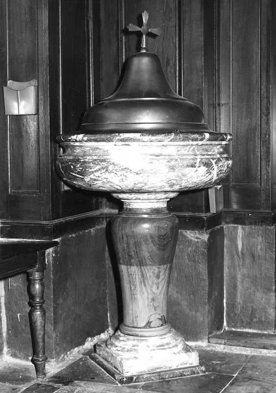
Image copyright © KIK-IRPA, Brussels (Belgium), 2026
CC-BY-4.0
Results: 2 records
view of font and cover
Copyright Statement: Image copyright © KIK-IRPA, Brussels (Belgium), 2026
Image Source: digital image of a 1976 B&W photograph [cliché M248463]
Copyright Instructions: CC-BY-4.0
view of church exterior - northwest view
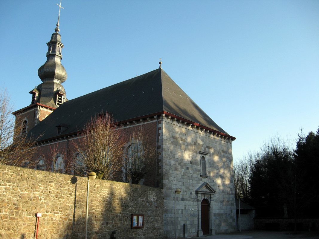
Scene Description: "Sint-Janskerk in Beaufays / Eglise Saint-Jean Evangéliste à Beaufays"
Copyright Statement: Image copyright © Sonuwe, 2011
Image Source: digital photograph 6 March 2011 by Sonuwe
Copyright Instructions: CC-BY-SA-3.0
INFORMATION
Font ID: 26150PJX
Object Type: Baptismal Font1
Font Century and Period/Style: 17th century (?), [altered] [composite]
Church / Chapel Name: Eglise Saint-Jean-l'Evangéliste à Beaufays / Sint-Janskerk
Font Location in Church: Inside, beneath the W gallery, N side
Church Patron Saint(s): St. John the Evangelist
Church Notes: medieval priory churchc; became parochial in 1903 [cf. FontNotes]
Church Address: Rte de l' Abbaye 102, 4052 Chaudfontaine, Belgium -- Tel: +32 475 89 98 76
Site Location: Liège, Wallonie / Wallonne, Belgium, Europe
Directions to Site: Located off (N) the N62 and Hwy E25, 11-12 km SE of Liège
Ecclesiastic Region: Diocèse de Liège / Bistum Lüttich
Additional Comments: altered font / composite font [cf. FontNotes]
Font Notes:
Click to view
Baptismal font listed and illustrated in BALaT KIK-IRPA [https://balat.kikirpa.be/object/10108840] [accessed 23 February 2026]: "fonts baptismaux [...] marbre [...] Date: 1601 - 1700 [...] hauteur: 95 cm; diamètre: 67 cm [...] Cf. couvercle : 10108841".
A communication to BSI from Pol Herman (e-mail of 27 January 2026] informs: "https://abbaye-beaufays.be/
https://fr.wikipedia.org/wiki/Prieur%C3%A9_de_Beaufays -- Bellefontaine, Bellum Fagetum, Bellus fons, Bealfais. Beaufays was a dependency of the royal Carolingian domain of Jupille, granted in 1008 by emperor Henry II to the bishop of Verdun. In 1266, the village was ceded to the bishop of Liège. The village's history is closely linked to that of the abbey. In 1123, Henry, bishop of Verdun, gave land in a place called Belle-Fontaine (Bellus Fons) to a certain Robert, who wished to establish an oratory dedicated to Our Lady and a hospital for the poor. The canons of this chapel adopted the rule of Saint Augustine in 1229. While the correct designation for the establishment would be “priory”, the name “abbey” would henceforth be used. In 1215, one of Henry’s successors donated to the monastery the forest called "Bellum Fagetum," from which the name Beaufays derives. Placed under the authority of the bishop of Verdun and later that of the Prince-Bishop of Liège, the small community of canons would endure more than seven centuries of a sometimes turbulent history. The oldest structure still visible today is the keep (donjon), erected in the 16th century to the south of the Priory. The abbey was damaged by an earthquake in 1692. The reconstruction work was primarily carried out by Henri de Goha, appointed Prior for Life in 1705 and who died in 1732. The old church was demolished in 1701 and rebuilt the same year, reusing the 17th-century square tower. Following the annexation of the Principality of Liège by France in 1795, the abbey was dissolved, its property was seized by the authorities and then put up for public sale. Four former canons bought back a large part of the buildings, which were then occupied for a few more years by former canons, until the death of the last of them in 1835. By virtue of the Concordat, the church had become a parish church in 1803, dedicated to Saint John the Evangelist. Baptismal records from 1771 onwards. Marble basin of baroque font, 17th c. https://balat.kikirpa.be/object/10108840".
Credit and Acknowledgements: We are grateful to Pol Herman for bringing this font to our attention and for his help documenting it
COORDINATES
UTM: 31U 687656 5604504
Latitude & Longitude (Decimal): 50.562291, 5.649651
Latitude & Longitude (DMS): 50° 33′ 44.25″ N, 5° 38′ 58.75″ E
MEDIUM AND MEASUREMENTS
Material: stone, marble
Font Shape: hemispheric (mounted)
Diameter (includes rim): 67 cm*
Font Height (less Plinth): 95 cm*
Notes on Measurements: * [cf. FontNotes]
LID INFORMATION
Material: metal
Notes: bell-shaped dome with cross finial
REFERENCES
- KIK-IRPA, BALaT KIK-IRPA, 2024. URL: https://balat.kikirpa.be/.