Buggenhout / Buchenout / Buckenhout / Buckenout / Bughenhout
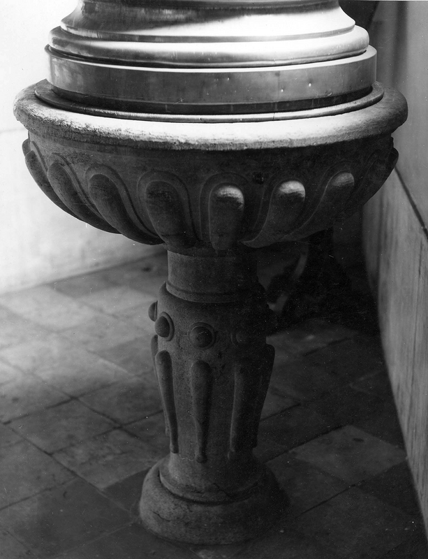
Image copyright © KIK-IRPA, Brussels (Belgium), 2026
CC-BY-NA
Results: 8 records
view of font
Copyright Statement: Image copyright © KIK-IRPA, Brussels (Belgium), 2026
Image Source: digital image of a 1945 B&W photograph [cliché B096569] by the Commissariaat generaal voor de Passieve Luchtbescherming
Copyright Instructions: CC-BY-NA
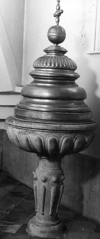
view of font and cover
Copyright Statement: Image copyright © KIK-IRPA, Brussels (Belgium), 2026
Image Source: digital image of a 1976 B&W photograph [cliché M061108] in KIK
Copyright Instructions: CC-BY-NA
design element - patterns - gadrooned
Copyright Statement: Image copyright © KIK-IRPA, Brussels (Belgium), 2026
Image Source: digital image of a 1945 B&W photograph [cliché B096569] by the Commissariaat generaal voor de Passieve Luchtbescherming
Copyright Instructions: CC-BY-NA
view of church exterior - southwest view
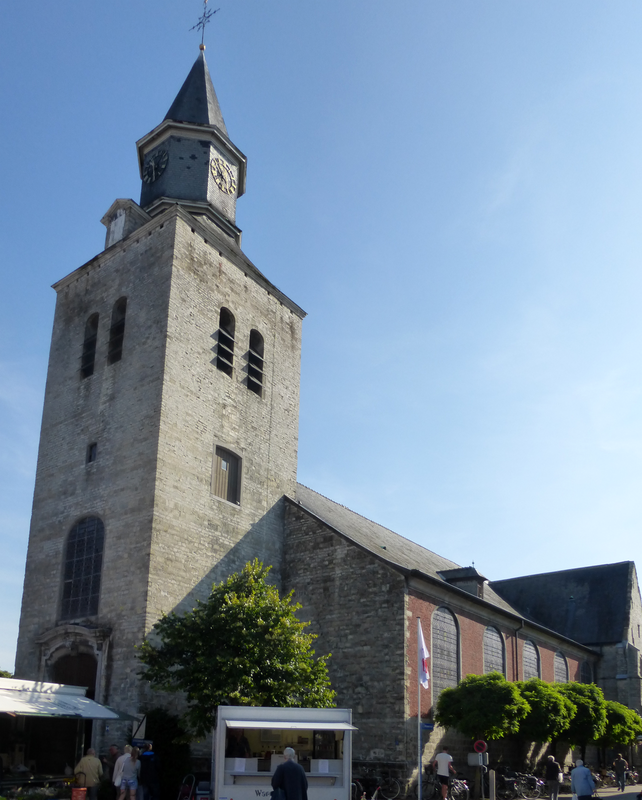
Scene Description: "Buggenhout Kerkstraat zonder nummer - 209194 - onroerenderfgoed"
Copyright Statement: Image copyright © Verhelst, Julie, 2014
Image Source: Idigital photograph 21 August 2014 by Verhelst, Julie
Copyright Instructions: CC-BY-SA-4.0
view of church interior - looking east
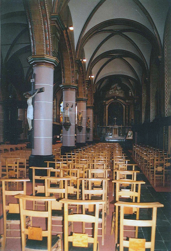
Scene Description: "Buggenhout Buggenhout Kerkstraat 101 - 249770 - onroerenderfgoed"
Copyright Statement: Image copyright © Bogaert, Chris, 2000
Image Source: digital photograph 8 June 2000 by Bogaert, Chris
Copyright Instructions: CC-BY-SA-4.0
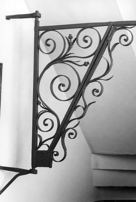
view of font cover - bracket - detail
Copyright Statement: Image copyright © KIK-IRPA, Brussels (Belgium), 2026
Image Source: digital image of a 1976 B&W photograph [cliché M061109] in KIK
Copyright Instructions: CC-BY-NA
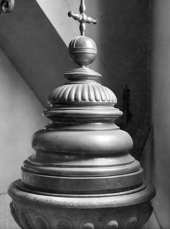
view of font cover
Copyright Statement: Image copyright © KIK-IRPA, Brussels (Belgium), 2026
Image Source: digital image of a 1945 B&W photograph [cliché B096568] by the Commissariaat generaal voor de Passieve Luchtbescherming
Copyright Instructions: CC-BY-NA
design element - patterns - ribbed
Copyright Statement: Image copyright © KIK-IRPA, Brussels (Belgium), 2026
Image Source: digital image of a 1945 B&W photograph [cliché B096569] by the Commissariaat generaal voor de Passieve Luchtbescherming
Copyright Instructions: CC-BY-NA
INFORMATION
Font ID: 26119PQR
Object Type: Baptismal Font1
Font Century and Period/Style: 17th century (early), Renaissance
Workshop/Group/Artisan: Hainaut type font
Cognate Fonts: [cf. FontNotes]
Church / Chapel Name: Sint-Niklaaskerk
Font Location in Church: Inside
Church Wikidata: https://nl.wikipedia.org/wiki/Sint-Niklaaskerk_(Buggenhout)
Church Patron Saint(s): St. Nicholas
Church Notes: 12thC(?) wooden building rebuilt in stone ca. 1500; damaged in 16thC Calvinistic revolts; retored 1602; much modified since
Church Address: Nieuwstraat 2, 9255 Buggenhout, Belgium -- Tel.: +32 52 41 05 95
Site Location: Oost-Vlaanderen / Flandre Est, Vlaanderen / Flandres, Belgium, Europe
Directions to Site: Located off (S) the N17, 8-9 km E of Dendermonde
Ecclesiastic Region: Bisdom Gent / Diocèse de Gand
Additional Comments: disappeared font? (the one from the medieval church here)
Town/City Wikipedia: https://nl.wikipedia.org/wiki/Buggenhout
Font Notes:
Click to view
The present font in this church is listed and illustrated in BALaT KIK-IRPA [ttps://balat.kikirpa.be/object/72638] [accessed 15 February 2026]: "doopvont [...] metaal, arduin, ijzer [...] hoogte kuip: 106,5 cm [...] Date: 1601 - 1650 [...] deksel in verkoperd metaal".
A communication to BSI from Pol Herman (e-mail of 12 February 2026) informs: "1202 Bugghenholt, 1231 Buchenout, 1236 Buckenout, 1236 Buckenhout, 1267 Bughenhout. Buggenhout was first mentioned in 1125, as Buckenholt, a large forested area. From the Carolingian period until the 11th century, Buggenhout was part of the Duchy of Brabant, but the Lords of Grimbergen also held rights in the area. Furthermore, Affligem Abbey was involved in the power struggle between lords and duke. Due to family disputes and the Abbey's intervention in conflicts, the estates were confiscated by the count. The forest was incorporated into the crown domain, and Buggenhout was divided into two lordships: Buggenhout-Bournonville (roughly corresponding to the present-day village center), where the Bournonville family ruled until 1765 and which became a prince-bishopric in 1658. Buggenhout-Grimbergen, which included the present-day villages of Opstal and Briel. The heavily forested land was reclaimed for agriculture, mainly by the abbeys of Affligem and Zwijveke. There was a castle belonging to the Lords of Buggenhout, with its own chapel and chaplain. It is unknown when the castle was built or demolished (probably after the French Revolution). The Buggenhout parish was created around 1100. Virtually nothing is known about the church's earliest history. It is certain only that the abbot of Affligem Abbey, that was founded around 1083, had the right of patronage over the St. Nicholas parish. A wooden building made way for a bluestone church around 1500. This church had a Greek cross plan and a crossing tower in the center. During the religious unrest of the second halve of the 16th c., bands of Calvinistic rebels invaded the village (circa 1574) and destroyed everything in the church. Fires were also started. The first surviving document relating to the restoration of the church dates from 1602. In 1647, the choir was extended and the church re-vaulted. Around 1649/1650, the transept was also renovated. Because the church had become too small, the nave was enlarged in 1781. In the same year, the dilapidated crossing tower was demolished and replaced by a west tower at the church entrance. Systematic inventory of baptisms from 1624 onwards, but many older baptismal records still exist. The baptismal font : The overall design of the renaissance, limestone, Hainaut-type font with gadroons is typical for the period 1590-1620, when many churches had to be repaired after the iconoclastic fury. An identical font stood in the Saint-Peter’s church at Testelt, now in the collection of the City Museum of Diest. An identical stoop stands in the church of Our Lady at Temse. Its basin carries two coats of arms : the family Verstraeten and the alliance arms Verstraeten-Moenins. According to the genealogic tables of the city of Temse, this alliance can only be the spouses Joos Verstraten (1586-1616), chief clerk of the lordship of Temse, and his wife Suzanne Moenins (1586-???). They were married in 1607. After Joos died, Suzanne married Cornelis Van Driel. The trace of Suzanne is lost after giving birth to her youngest child Elisabeth in 1631. The stoup of Temse therefore dates from 1607…1616. This would be an acceptable period for the font of Buggenhout. https://balat.kikirpa.be/object/72638"
A communication to BSI from Pol Herman (e-mail of 12 February 2026) informs: "1202 Bugghenholt, 1231 Buchenout, 1236 Buckenout, 1236 Buckenhout, 1267 Bughenhout. Buggenhout was first mentioned in 1125, as Buckenholt, a large forested area. From the Carolingian period until the 11th century, Buggenhout was part of the Duchy of Brabant, but the Lords of Grimbergen also held rights in the area. Furthermore, Affligem Abbey was involved in the power struggle between lords and duke. Due to family disputes and the Abbey's intervention in conflicts, the estates were confiscated by the count. The forest was incorporated into the crown domain, and Buggenhout was divided into two lordships: Buggenhout-Bournonville (roughly corresponding to the present-day village center), where the Bournonville family ruled until 1765 and which became a prince-bishopric in 1658. Buggenhout-Grimbergen, which included the present-day villages of Opstal and Briel. The heavily forested land was reclaimed for agriculture, mainly by the abbeys of Affligem and Zwijveke. There was a castle belonging to the Lords of Buggenhout, with its own chapel and chaplain. It is unknown when the castle was built or demolished (probably after the French Revolution). The Buggenhout parish was created around 1100. Virtually nothing is known about the church's earliest history. It is certain only that the abbot of Affligem Abbey, that was founded around 1083, had the right of patronage over the St. Nicholas parish. A wooden building made way for a bluestone church around 1500. This church had a Greek cross plan and a crossing tower in the center. During the religious unrest of the second halve of the 16th c., bands of Calvinistic rebels invaded the village (circa 1574) and destroyed everything in the church. Fires were also started. The first surviving document relating to the restoration of the church dates from 1602. In 1647, the choir was extended and the church re-vaulted. Around 1649/1650, the transept was also renovated. Because the church had become too small, the nave was enlarged in 1781. In the same year, the dilapidated crossing tower was demolished and replaced by a west tower at the church entrance. Systematic inventory of baptisms from 1624 onwards, but many older baptismal records still exist. The baptismal font : The overall design of the renaissance, limestone, Hainaut-type font with gadroons is typical for the period 1590-1620, when many churches had to be repaired after the iconoclastic fury. An identical font stood in the Saint-Peter’s church at Testelt, now in the collection of the City Museum of Diest. An identical stoop stands in the church of Our Lady at Temse. Its basin carries two coats of arms : the family Verstraeten and the alliance arms Verstraeten-Moenins. According to the genealogic tables of the city of Temse, this alliance can only be the spouses Joos Verstraten (1586-1616), chief clerk of the lordship of Temse, and his wife Suzanne Moenins (1586-???). They were married in 1607. After Joos died, Suzanne married Cornelis Van Driel. The trace of Suzanne is lost after giving birth to her youngest child Elisabeth in 1631. The stoup of Temse therefore dates from 1607…1616. This would be an acceptable period for the font of Buggenhout. https://balat.kikirpa.be/object/72638"
Credit and Acknowledgements: We are grateful to Pol Herman for bringing this font to our attention and for his help documenting it
COORDINATES
UTM: 31U 584373 5652217
Latitude & Longitude (Decimal): 51.015319, 4.202831
Latitude & Longitude (DMS): 51° 0′ 55.15″ N, 4° 12′ 10.19″ E
MEDIUM AND MEASUREMENTS
Material: stone
Font Shape: hemispheric (mounted)
Basin Exterior Shape: round
LID INFORMATION
Material: metal, brass
Apparatus: yes; side bracket
Notes: moulded dome with orb-and-cross finial [cf. FontNotes & ImagesArea]