Boussu-en-Fagne / Boussu-el-Fagne / Boussu-en-Fagnes
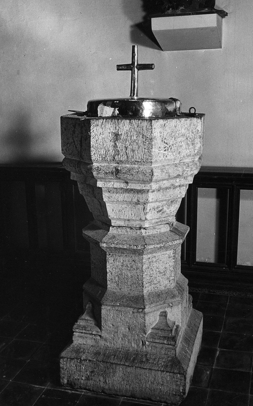
Image copyright © KIK-IRPA, Brussels (Belgium), 2026
CC-BY-4.0
Results: 2 records
view of font and cover
Scene Description: the font dated to ca. 1855 in KIK-IRPA [cf. FontNotes]
Copyright Statement: Image copyright © KIK-IRPA, Brussels (Belgium), 2026
Image Source: digital image of a 1973 by B&W photograph [cliché M097643] by Massart, Jean-Louis [https://balat.kikirpa.be/object/10078657] [accessed 23 January 2026]
Copyright Instructions: CC-BY-4.0
view of church exterior - northwest view
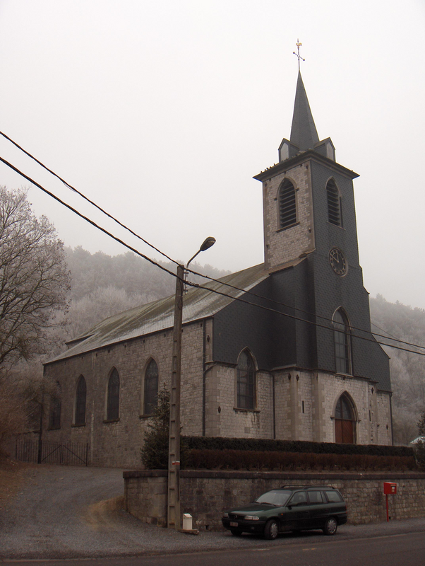
Scene Description: "Pfarrkirche (église Saint-Sulpice) von Boussu-en-Fagne (Ortsteil von Couvin, Prov. Namur, Belgien)"
Copyright Statement: Image copyright © Friedrich Tellberg, 2006
Image Source: digital photograph 2 February 2006 by Friedrich Tellberg
Copyright Instructions: GFDL / CC-BY-SA-3.0
INFORMATION
Font ID: 26065XFW
Object Type: Baptismal Font1
Font Century and Period/Style: 12th - 15th century (?), Medieval?
Church / Chapel Name: Eglise St-Sulpice à Boussu-en-Fagne
Church Patron Saint(s): St. Sulpitius
Church Notes: original castle church; a church documented in the 15thC [cf. FontNotes]
Church Address: rue du Hachet, 5660 Couvin, Belgium
Site Location: Namur, Wallonie / Wallonne, Belgium, Europe
Directions to Site: Located off the N939, in the municipality and 4 km NW of Couvin, about 15 km E of Chimay
Ecclesiastic Region: Diocèse de Namur
Additional Comments: is the present font dated ca. 1855 a composite? [cf. FontNotes] -- disappeared font? (the one from the original church here)
Font Notes:
Click to view
A baptismal font of stone dated to ca, 1855 is listed and illustrated in BALaT KIK-IRPA [https://balat.kikirpa.be/object/10078657] [accessed 23 January 2026].
A communication to BSI from Pol Herman (e-mail of 18 December 2025) informs: "https://fr.wikipedia.org/wiki/Boussu-en-Fagne. Boussu, along with Couvin and its dependencies, was purchased in 1096 by Otbert, Prince-Bishop of Liège, from the Count of Hainaut. He immediately had the castle demolished, but was soon rebuilt. The castle was destroyed in 1555 by the Prince of Orange. The castle church was located near the castle, originally enclosing it within its walls. In 1435, Philippe de Savigny, lord of Orchimont, resumed looting raids in the lands of the Prince-Bishop of Liège and he surprised the inhabitants of Boussu while they were at Mass. He besieged the church. Those who refused to surrender were beaten and wounded, so much so that “blood flowed onto the altar”. The lord of the Boussu castle managed to escape, but the priest and several parishioners were taken captive. Prince-Bishop Jean de Heinsberg gathered the troops of his allies. He attacked the fortress of Bosenove (Bosnau, Boussenoch, Bourssenove, Boussenolt)-sur-Sambre. The brigands surrendered. There were 31 of them. They were all hanged. Their chaplain was tied to a tree and burned. Fifteen prisoners were released. Church mentioned in 1497. On February 18, 1575, Lord Jean Marotte, also canon of Saint-Aubin Cathedral in Namur, obtained from Robert de Berghes, Bishop of Liège, the establishment of the church of Boussu as a parish, which until then had been considered simply a castle chapel, dependent on the parish of Frasnes (mentioned as such in 1558). In 1632, the locality was ravaged by the Spanish troops of Governor Chimay. 1855: A new neo-Gothic church was built on a new site by the municipality. It contains funerary slabs dating from the 17th and 18th centuries. The castle church was demolished. Baptismal records : 1589.
The mosan-type baptismal font is said to be from 1855, when the new church was built. The base and the column however have renaissance looks, and the design of the basin does not really fit to these features. https://balat.kikirpa.be/object/10078657"
Credit and Acknowledgements: We are grateful to Pol Herman for bringing this font to our attention and for his help in documenting it
COORDINATES
Latitude & Longitude (Decimal): 50.067, 4.467
Latitude & Longitude (DMS): 50° 4′ 1.2″ N, 4° 28′ 1.2″ E