Etersheim / Eitersem
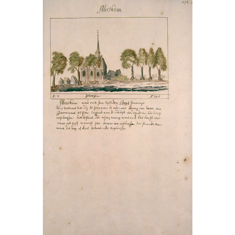
Image copyright © [in the public domain]
CC-PD-Mark / PD-Art (PD-old-100)
Results: 4 records
view of church exterior in context
Scene Description: Source caption: "Atlas Schoemaker-WESTFRIESLAND-DEEL2-494-Noord-Holland, Etersheim"
Copyright Statement: Image copyright © [in the public domain]
Image Source: digital image by the KB National Library of the Netherlands of an illustration between 1710 and 1735, in the Atlas Schoemaker: Noord-Holland, Etersheim [https://commons.wikimedia.org/wiki/File:Atlas_Schoemaker-WESTFRIESLAND-DEEL2-494-Noord-Holland,_Etersheim.jpeg] [accessed 3 February 2025]
Copyright Instructions: CC-PD-Mark / PD-Art (PD-old-100)
view of church exterior - northeast view
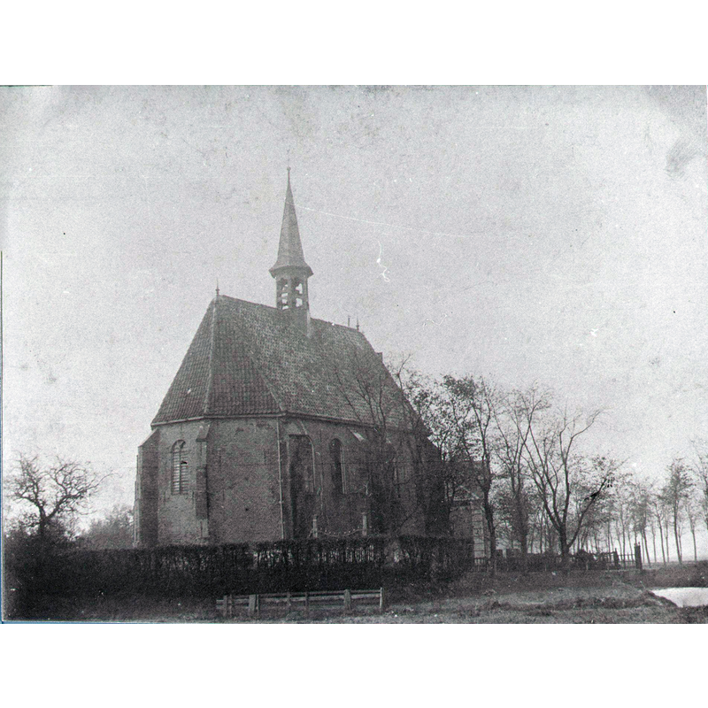
Scene Description: Source caption: "Oude Kerk Etersheim voor 1900"
Copyright Statement: Image copyright © [in the public domain]
Image Source: digital image of a pre-1900 B&W photograph in the Waterlands Archief [https://commons.wikimedia.org/wiki/File:Oude_Kerk_Etersheim_voor_1900.jpg] [accessed 3 February 2025]
Copyright Instructions: PD-old missing SDC copyright status / CC-PD-Mark / PD Old
view of church interior - looking east
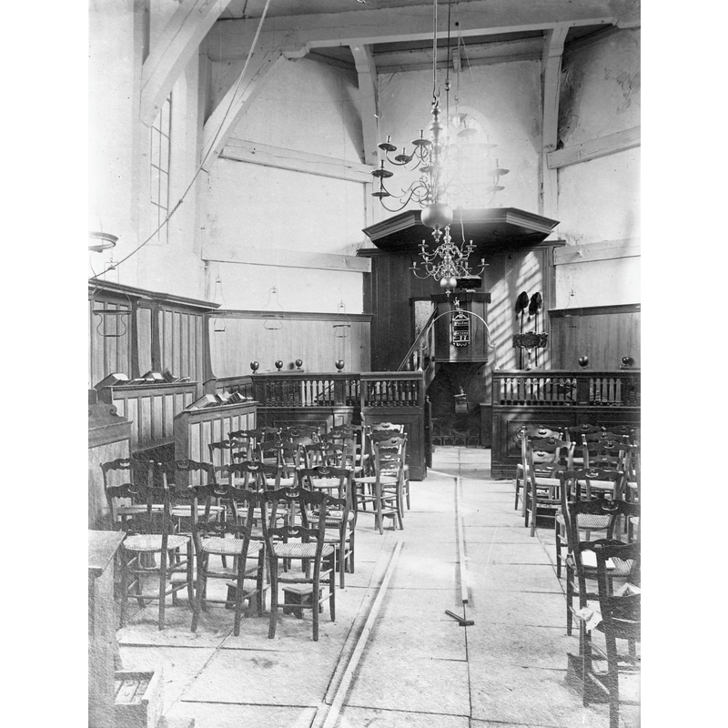
Scene Description: Source caption: "Nederlands Hervormde Kerk (Etersheim) inwendig"
Copyright Statement: Image copyright © Rijksdienst voor het Cultureel Erfgoed, 2025
Image Source: digital image of a March 1901 B&W photograph in the Rijksdienst voor het Cultureel Erfgoed [https://commons.wikimedia.org/wiki/File:Inwendig_-_Etersheim_-_20072469_-_RCE.jpg] [accessed 3 February 2025]
Copyright Instructions: CC-BY-SA-4.0
view of church interior - sarcophagus
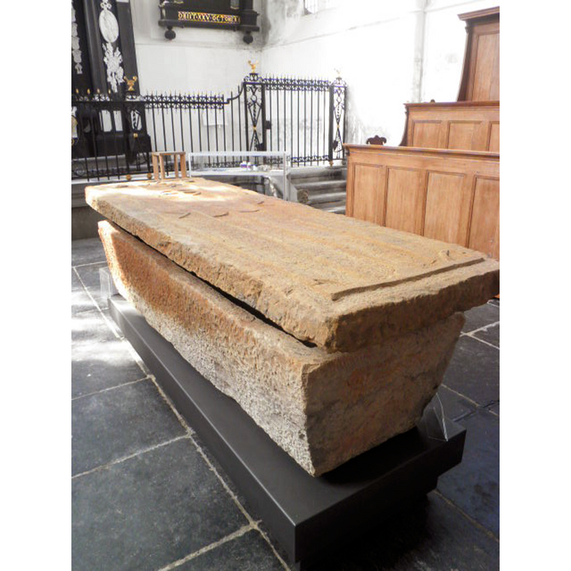
Scene Description: Source caption: "Sarcofaag, tussen 2006 en 2008 uit het Markermeer bij Etersheim gehaald. Deksel bestond uit twee delen, verer compleet." -- the 12thC(?) sarcophagus from Etersheim, recovered from the sunken church at sea
Copyright Statement: Image copyright © Dqfn13, 2012
Image Source: digital photograph 2 May 2012 by Dqfn13 [https://commons.wikimedia.org/wiki/File:Sarcofaag_uit_Etersheim.JPG] [accessed 3 February 2025]
Copyright Instructions: CC-BY-SA-3.0
INFORMATION
Font ID: 25815ETE
Object Type: Baptismal Font1?
Font Date: n.d.
Font Century and Period/Style: 12th - 13th century (?), Medieval
Church / Chapel Name: Oude Kerk te Etersheim [disappeared church]
Font Location in Church: [disappeared]
Church Notes: old church sunk into the Zuiderzee in the 16thC; new church built in 1901; later deconsecrated and became a B&B
Church Address: [address & coordinates given for the present village]
Site Location: Noord-Holland, Netherlands
Directions to Site: The new village is located off the N247, in the municipality of Edam-Volendam, about 2 km NE of Oosthuizen, on the E coast of the peninsula
Additional Comments: disappeared font? / sunken font? [cf. FontNotes]
Font Notes:
Click to view
The medieval church and the village itself sank into the Zuiderzee; some items were recovered by divers in August 2009, among them a 12th-century stone sarcophagus and an elaborately carved tombstone, now in the nearby church at Oosthuizen.
A communication to BSI from Pol Herman (e-mail of 2 February 2025) informs: "The old village of Etersheim has been flooded by the sea in the 16th century. In 2001, during an archaeological dive, the foundations of the original village church were found. 8 years later, in August 2009, thanks to sonar pictures, a sarcophagus from the 12th century was found on the seabed. Because of the dangerous conditions for the divers, visibility being nil, and because the ministry did not grant permission for further archaeological exploration, the site was abandoned for many years. It was not possible to follow up the possible baptismal font that divers detected by touch. Its location was not documented. It is however know that amateur divers continued to scavenge the site, on search of gold coins and valuable artefacts. Because planned reinforcement of the dikes would damage the site, a remote sensing device was installed in 2020, to scan the bottom (see picture). Also photogrammetric cameras and remote robots were used to identify and recover objects. The previously noticed foundations of the church could not be found. All that was observed were loose bricks and tuff stones."
A communication to BSI from Pol Herman (e-mail of 2 February 2025) informs: "The old village of Etersheim has been flooded by the sea in the 16th century. In 2001, during an archaeological dive, the foundations of the original village church were found. 8 years later, in August 2009, thanks to sonar pictures, a sarcophagus from the 12th century was found on the seabed. Because of the dangerous conditions for the divers, visibility being nil, and because the ministry did not grant permission for further archaeological exploration, the site was abandoned for many years. It was not possible to follow up the possible baptismal font that divers detected by touch. Its location was not documented. It is however know that amateur divers continued to scavenge the site, on search of gold coins and valuable artefacts. Because planned reinforcement of the dikes would damage the site, a remote sensing device was installed in 2020, to scan the bottom (see picture). Also photogrammetric cameras and remote robots were used to identify and recover objects. The previously noticed foundations of the church could not be found. All that was observed were loose bricks and tuff stones."
Credit and Acknowledgements: We are grateful to Pol Herman for bringing this church and font to our attention
COORDINATES
UTM: 31U 637001 5828027
Latitude & Longitude (Decimal): 52.585, 5.0222
Latitude & Longitude (DMS): 52° 35′ 6″ N, 5° 1′ 19.92″ E