Rumbeke No. 2
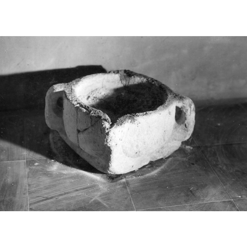
Image copyright © KIK-IRPA, Brussels (Belgium), 2024
CC-BY-4.0
Results: 1 records
view of object
Scene Description: former mortar re-purposed as baptismal font [cf. FontNotes]
Copyright Statement: Image copyright © KIK-IRPA, Brussels (Belgium), 2024
Image Source: digital image of a 1942 B&W photograph [cliché A027468] in BALaT KIK-IRPA [https://balat.kikirpa.be/object/42078] [accessed 15 September 2024]
Copyright Instructions: CC-BY-4.0
INFORMATION
Font ID: 25710RUM
Object Type: Baptismal Font1, fragment?
Font Date: n.d.
Font Century and Period/Style: 16th century
Church / Chapel Name: Parochiekerk Sint-Petrus en Paulus in Rumbeke
Font Location in Church: Inside the church
Church Patron Saint(s): St. Peter & St. Paul
Church Address: Kerkplein, Rumbeke, 8800 Roeselare, Belgium
Site Location: West-Vlaanderen / Flandre Occidentale, Vlaanderen / Flandres, Belgium, Europe
Directions to Site: Located off road N357, in the municipality and 2-3 km SE of Roeselare, about 16 km NNW of Kortrijk
Ecclesiastic Region: Bisdom Brugge
Additional Comments: re-purposed mortar(?) / measure(?) (used as font [cf. FontNotes])
Font Notes:
Click to view
A late-medieval mortar(?) re-purposed as baptismal font is listed and illustrated in BALaT KIK-IRPA [https://balat.kikirpa.be/object/42078] [accessed 15 September 2024]: "doopvont, vijzel [...] Date: 1501 (onzeker) - 1600 (onzeker) [...] terracotta [...] Vijzel die als vijzels als doopvont werd hergebruikt." [NB: if it is made of terracotta it is more likely to have been originally made as a grain measure than a mortar]
COORDINATES
UTM: 31U 510871 5642439
Latitude & Longitude (Decimal): 50.933478, 3.154703
Latitude & Longitude (DMS): 50° 56′ 0.52″ N, 3° 9′ 16.93″ E
MEDIUM AND MEASUREMENTS
Material: ceramic
Font Shape: square (unmounted)
Basin Interior Shape: square
Basin Exterior Shape: square
REFERENCES
- KIK-IRPA, BALaT KIK-IRPA, 2024. URL: https://balat.kikirpa.be/.