Oostmalle No. 2
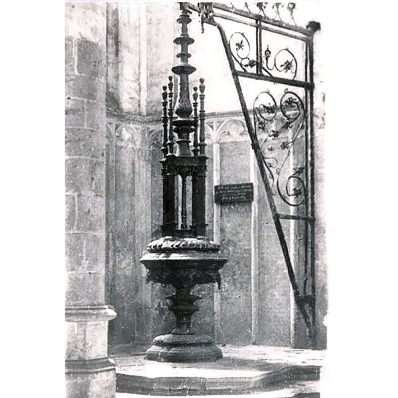
Image copyright © [in the public domain]
Assumed PD
Results: 1 records
view of font and cover
Scene Description: In 1628 Peter de Roover supplied a new font for the price of 22 guilders (including brass lid) -- this font that has also disappeared [cf. FontNotes]
Copyright Statement: Image copyright © [in the public domain]
Image Source: digital image of an undated [pre-1936?] B&W photograph [source N/A] provided by Pol Herman
Copyright Instructions: Assumed PD
INFORMATION
Font ID: 25406OOS
Object Type: Baptismal Font1
Font Date: 1628
Font Century and Period/Style: 17th century
Church / Chapel Name: Parochiekerk Sint-Laurentius Oostmalle
Font Location in Church: [cf. FontNotes]
Church Patron Saint(s): St. Lawrence [aka Laurence]
Church Address: Oostmalle, 2390 Malle, Belgium
Site Location: Antwerp, Vlaanderen / Flandres, Belgium, Europe
Directions to Site: Oostmalle is located of the N12-N14 crossroads, in the municipality of Malle, 25-30 km ENE of Antwerp
Additional Comments: price of a new font and cover in 1628: 22 guilders [cf. FontNotes]
Font Notes:
Click to view
De Molder (1936) writes of a font that replaced the earlier one in this church in 1628, when Peter de Roover supplied a new font for the price of 22 guilders (including brass lid), a font that has also disappeared. This font is not listed in KIK-IRPA
A communication to BSI from Pol Herman (e-mail of 26 November 2023) informs about the confusing situation related to this font:
- This brass font is said to have been lost when a tornado struck the village on 25th of June 1967, when the church was totally destroyed, and a new building was constructed next to it
- I find conflicting dates for this font: 1602 and 1628, but it is probably the font supplied by Peter de Roover for the price of 22 guilders (including brass lid) documented in De Molder [cf. supra]. Some sources report this font as disappeared in/by 1936, which makes the available photograph [cf. ImagesArea] pre-1936
- why does the local historical society say that that this font was only destroyed in 1967, when a tornado destroyed the whole church? in which case, why can nobody find pictures of it after the Second World War? Pol Herman further notes that Luc Cox, local historian, Heemkundige Kring van Malle vzw, Lierselei 28 bus 2, 2390 Malle, Belgium info@heemkundigekringmalle.be / www.heemkundigekringmalle.be "is still searching for clues"
Credit and Acknowledgements: We are grateful to Pol Herman for bringing this object to our attention and for his help in documenting it
COORDINATES
UTM: 31U 620809 5684755
Latitude & Longitude (Decimal): 51.301275, 4.732972
Latitude & Longitude (DMS): 51° 18′ 4.59″ N, 4° 43′ 58.7″ E
MEDIUM AND MEASUREMENTS
Material: metal, brass
Font Shape: round, mounted
Basin Exterior Shape: round
LID INFORMATION
Date: 1628?
Material: metal, brass?
Apparatus: yes; wall-mounted side crane
Notes: [cf. FontNotes & ImagesArea]
REFERENCES
- De Molder, Th., "De Romaansche Doopvonten van OostmalIe en Tielen", niewe reeks viii (1936), nr. 4, Taxandria, 1936, pp. [205]-212; [https://www.taxandriavzw.be/media/files/pdf/Taxandria_1936_4_v2.pdf] [accessed 31 March 2024]