Eke nr. Nazareth
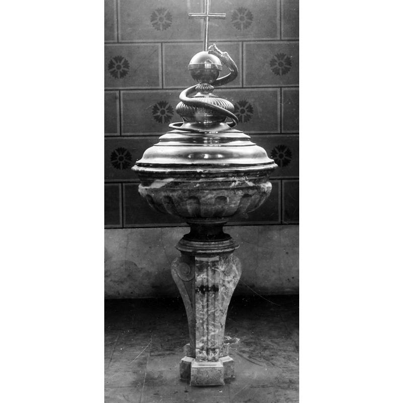
Image copyright © KIK-IRPA, Brussels (Belgium), 2023
Reproduced in accordance with KIK-IRPA guidelines
Results: 3 records
view of font and cover
Scene Description: the 19th-century (1859) baptismal font in the new parish church
Copyright Statement: Image copyright © KIK-IRPA, Brussels (Belgium), 2023
Image Source: digital image of a 1943 B&W photograph [cliché A057778] by the Commissariaat Generaal voor 's Lands Wederopbouw, in BALaT KIK-IRPA [https://balat.kikirpa.be/object/16174] [accessed 23 November 2023]
Copyright Instructions: Reproduced in accordance with KIK-IRPA guidelines
view of church exterior in context
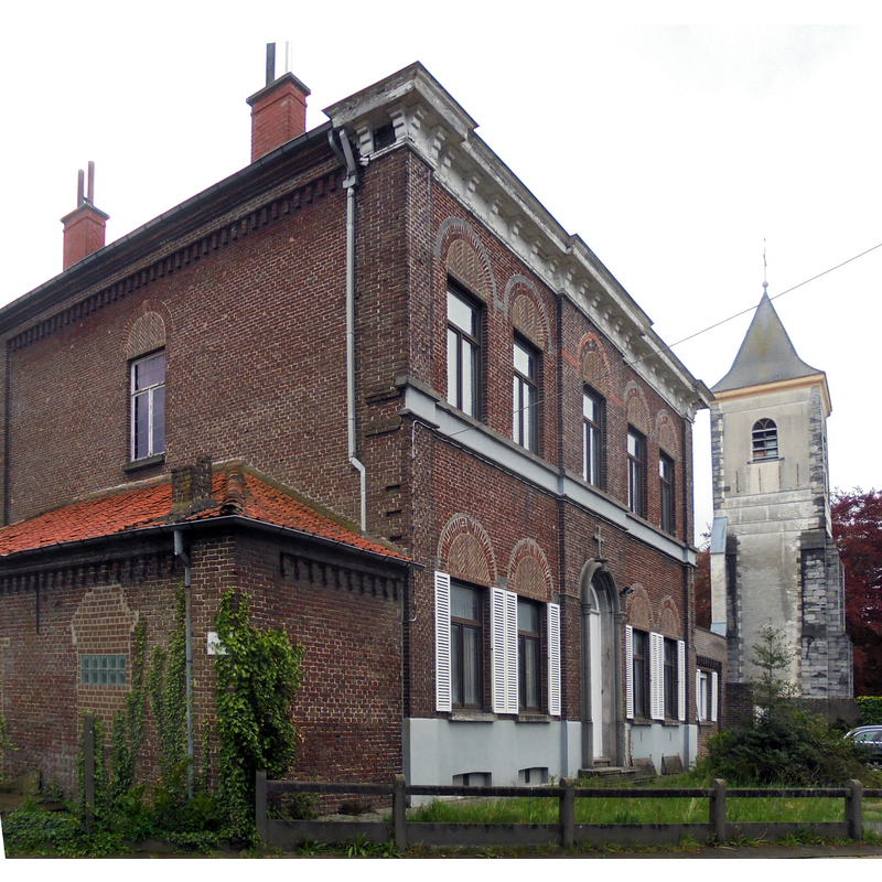
Scene Description: Source caption: "Links de pastorie met daarnaast de toren van de voormalige Sint-Amanduskerk - Noël Schoorensstraat - Eke - Nazareth - Oost-Vlaanderen - België." -- the former vicarage-cum-school in the foreground, with the tower of the former parish church in the background; a font from the latter stands in the garden of the former
Copyright Statement: Image copyright © Spotter2, 2019
Image Source: edited detail of a digital photograph 5 May 2019 by Spotter2 [https://commons.wikimedia.org/wiki/File:Pastorie_en_Toren_voormalige_Kerk_-_Eke.jpg] [accessed 23 November 2023]
Copyright Instructions: CC-BY-SA-4.0
view of church exterior - tower
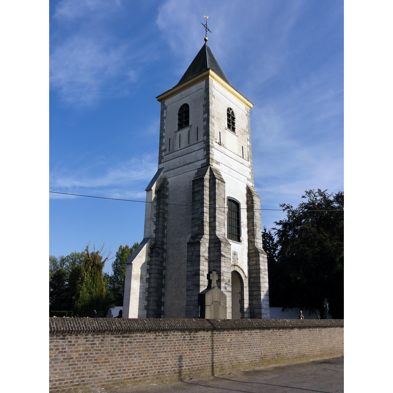
Scene Description: Source caption: "Former Sint-Amanduskerk (Church of Saint Amand) in Eke. Eke, Nazareth, East Flanders, Belgium"
Copyright Statement: Image copyright © LimoWreck, 2011
Image Source: digital photograph 24 September 2011 by LimoWreck [https://commons.wikimedia.org/wiki/File:Eke_-_Former_Sint-Amanduskerk_2.jpg] [accessed 23 November 2023]
Copyright Instructions: CC-BY-SA-3.0
INFORMATION
Font ID: 25092EKE
Object Type: Baptismal Font1
Font Date: n.d.
Font Century and Period/Style: 17th century
Church / Chapel Name: Voormalige Sint-Amanduskerk in Eke
Font Location in Church: In the old vicarage garden
Church Patron Saint(s): St. Amand [aka Amandus]
Church Notes: original church documented 1123; re-built 17th, 18thC; modified 1857; partly demolished but old tower partly retained-- present church built on a new site in 1912, north of the old parish church; badly damaged in WWI; repaired and consecrated in 1933
Church Address: Kerkplein, Eke, 9810 Nazareth, Belgium -- Tel.: +32 9 385 42 40
Site Location: Oost-Vlaanderen / Flandre Est, Vlaanderen / Flandres, Belgium, Europe
Directions to Site: Only the tower of the earlier church remains now, near the Oude Scheldt, off (W) the N260, in the municipality and 3 km E of Nazareth, about 13 km SW of Ghent
Ecclesiastic Region: Bisdom Gent / Diocèse de Gand
Additional Comments: disused font (in the old vicarage garden) -- disappeared font (the one from the 12thC church here)
Font Notes:
Click to view
The entry for the Pastorie Eke in Cultuurregio Leie Schelde [https://cultuurregioleieschelde.be/erfgoedhalte/pastorie-eke/] [accessed 23 November 2023] reports and illustrates the presence of a baptismal font in the garden of the former vicarage and school; it is described as being originally from the old parish church at Eke ["Ondertussen is het gebouw beschermd en krijgt het een nieuwe functie. In de tuin staat de doopvont uit de oude Eekse kerk"]. The font in the old vicarage consists of a roughly hemispherical basin decorated with a simple torus-scotia below the upper rim, raised on a pedestal base and a square lowe base; judging by the design it could date anywhere between the 16th and the 19th century, from one of the several re-buildings and modifications of the medieval church. [NB: the baptismal font in the new church is listed in the Inventaris Onroerend Erfgoed [https://id.erfgoed.net/erfgoedobjecten/38681] [accessed 23 November 2023] as modern, made of marble in the 19th century ["Marmeren 19de-eeuws doopvont"]].
A communication to BSI by Pol Herman (e-mail of 7 January 2023) confirms that the font now in the vicarage, "is mentioned in an inventory made by the priest Franciscus Hamelynck, who was appointed in 1724", and that "The 17th century limestone baptismal font was installed in the garden of the vicarage."
A communication to BSI by Pol Herman (e-mail of 7 January 2023) confirms that the font now in the vicarage, "is mentioned in an inventory made by the priest Franciscus Hamelynck, who was appointed in 1724", and that "The 17th century limestone baptismal font was installed in the garden of the vicarage."
Credit and Acknowledgements: We are grateful to Pol Herman for his help in documenting this font
COORDINATES
UTM: 31U 545137 5645016
Latitude & Longitude (Decimal): 50.954991, 3.64264
Latitude & Longitude (DMS): 50° 57′ 17.97″ N, 3° 38′ 33.5″ E
MEDIUM AND MEASUREMENTS
Material: stone, limestone
Font Shape: hemispheric, mounted
Basin Interior Shape: round
Basin Exterior Shape: round