Bruges No. 12 / Brugge
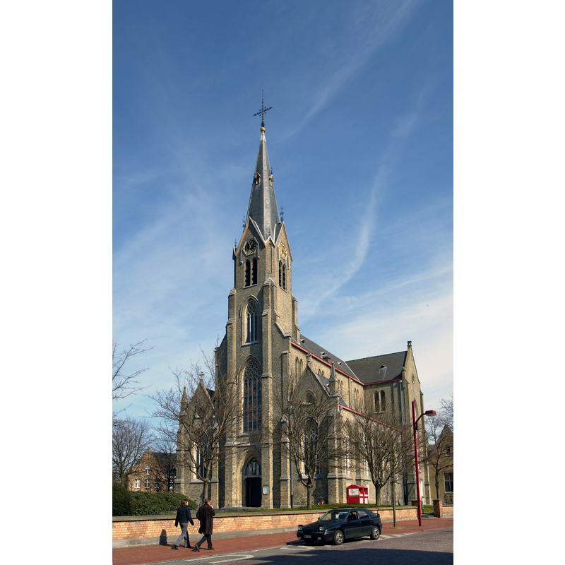
Image copyright © Kris Vandevorst, 2005
CC-BY-SA-4.0
Results: 5 records
view of church exterior - southwest view
Scene Description: Source caption: "Parochiekerk van de Heilige Kruisverheffing en de Heilige Jozef te St-Kruis"
Copyright Statement: Image copyright © Kris Vandevorst, 2005
Image Source: digital photograph 2005 by Kris Vandevorst [https://beeldbank.onroerenderfgoed.be/images/370161] [accessed 14 November 2023]
Copyright Instructions: CC-BY-SA-4.0
view of church interior - looking east
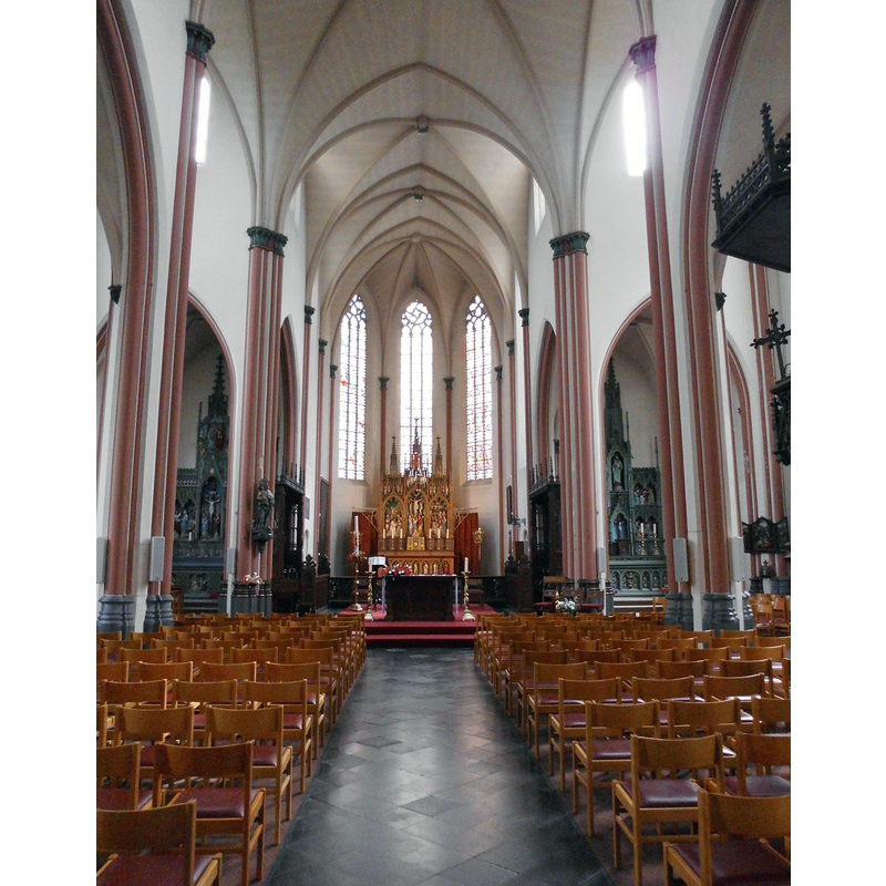
Scene Description: Source caption: "Interieur van Parochiekerk van de Heilige Kruisverheffing en de Heilige Jozef - Moerkerksesteenweg - Sint-Kruis - Brugge - West-Vlaanderen - België"
Copyright Statement: Image copyright © Spotter2, 2015
Image Source: digital photograph 25 May 2015 by Spotter2 [https://commons.wikimedia.org/wiki/File:Interieur_van_de_Parochiekerk_van_de_Heilige_Kruisverheffing_en_de_Heilige_Jozef_-_Sint-Kruis.jpg] [accessed 14 November 2023]
Copyright Instructions: CC-BY-SA-4.0
view of font and cover in context
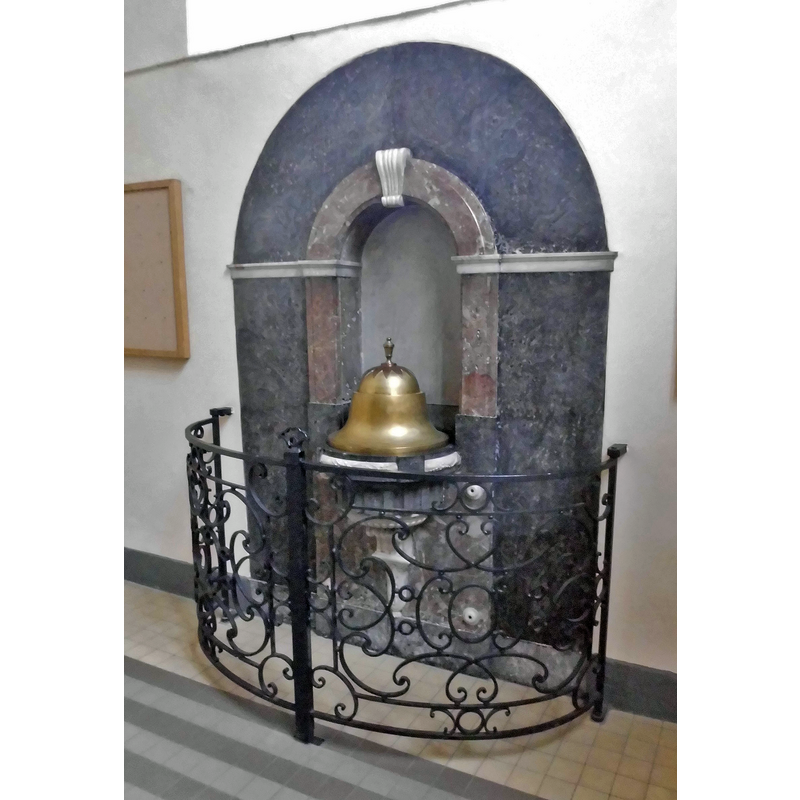
Scene Description: Source caption: "Doopvont van de Parochiekerk van de Heilige Kruisverheffing en de Heilige Jozef - Moerkerksesteenweg - Sint-Kruis - Brugge - West-Vlaanderen - België"
Copyright Statement: Image copyright © Spotter2, 2015
Image Source: digital photograph 25 May 2015 by Spotter2 [https://commons.wikimedia.org/wiki/File:Doopvont_Sint-Kruis.jpg] [accessed 14 November 2023]
Copyright Instructions: CC-BY-SA-4.0
view of font in context
![although dated in KIK-IRPA "1601 - 1700", the font is of a later period, the late 18thC, as per the "1790 - 1795" dating assigned to it in the Erfgoed Brugge [https://zoeken.erfgoedbrugge.be/detail.php?id=965730777&titel=Classicistisch doopvont, doopvont]" [accessed 14 November 2023]](/static-50478a99ec6f36a15d6234548c59f63da52304e5/compressed/1231114005_compressed.png)
Scene Description: although dated in KIK-IRPA "1601 - 1700", the font is of a later period, the late 18thC, as per the "1790 - 1795" dating assigned to it in the Erfgoed Brugge [https://zoeken.erfgoedbrugge.be/detail.php?id=965730777&titel=Classicistisch doopvont, doopvont]" [accessed 14 November 2023]
Copyright Statement: Image copyright © KIK-IRPA, Brussels (Belgium), 2023
Image Source: digital image of a 1944 B&W pgotograph [cliché A066601] by the Commissariaat Generaal voor 's Lands Wederopbouw, in BALaT KIK-IRPA [https://balat.kikirpa.be/object/85434] [accessed 14 November 2023]
Copyright Instructions: Reproduced in accordance with KIK-IRPA guidelines
view of font and cover
![although dated in KIK-IRPA "1601 - 1700", the font is of a later period, the late 18thC, as per the "1790 - 1795" dating assigned to it in the Erfgoed Brugge [https://zoeken.erfgoedbrugge.be/detail.php?id=965730777&titel=Classicistisch doopvont, doopvont]" [accessed 14 November 2023]](/static-50478a99ec6f36a15d6234548c59f63da52304e5/others/permission_not_available.jpg)
Scene Description: although dated in KIK-IRPA "1601 - 1700", the font is of a later period, the late 18thC, as per the "1790 - 1795" dating assigned to it in the Erfgoed Brugge [https://zoeken.erfgoedbrugge.be/detail.php?id=965730777&titel=Classicistisch doopvont, doopvont]" [accessed 14 November 2023]
Copyright Statement: Image copyright © Erfgoed Brugge, 2023
Image Source: digital image from Erfgoed Brugge [https://zoeken.erfgoedbrugge.be/detail.php?id=965730777&titel=Classicistisch doopvont, doopvont]" [accessed 14 November 2023]
Copyright Instructions: PERMISSION NOT AVAILABLE – IMAGE NOT FOR PUBLIC USE
INFORMATION
Font ID: 25066BRU
Object Type: Baptismal Font1?
Font Date: n.d.
Font Century and Period/Style: 10th - 15th century, Medieval
Church / Chapel Name: Sint-Kruis [cf. FontNotes]
Font Location in Church: [cf. FontNotes]
Church Patron Saint(s): The Holy Cross
Church Notes: 9th-10thC church; mentioned 1089 as chapel on the Roman roads between Oudenburg to Aardenburg; countess Margareta van de Elzas is buried in the church of Sint-Kruis in 1194; the parish of Sint-Kruis split into two by the move of the city wall/ramparts, the church itself falls outside the walls; 1383 church destroyed by Ghent insurgents; new church built inside the walls pre-1400;
Church Address: [NB: address & coordinates are for the present Sint-Kruis church] Moerkerkse Steenweg, 8310 Brugge, Belgium
Site Location: West-Vlaanderen / Flandre Ouest, Vlaanderen / Flandres, Belgium, Europe
Directions to Site: The present Sint-Kruis church is located off the Moerkerkse Steenweg, outside (E) the R20 ring road, in the E outskirts of Bruges [cf. FontNotes]
Ecclesiastic Region: Diocèse de Bruges / Bisdom Brugge
Additional Comments: disappeared fonts (those from the medieval churches of the Sint-Cross parish built and demolished through the ages)
Font Notes:
Click to view
The Erfoed Brugge entry for the baptismal font in the Sint-Kruis, Kerkbestuur Heilige Kruisverheffing en Sint-Jozef church [https://zoeken.erfgoedbrugge.be/detail.php?id=965730777&titel=Classicistisch doopvont, doopvont]" [accessed 14 November 2023] reads: "Classicistisch doopvont [...] Objectnummer PWV.0710.0363a [...] Doopvont uitgevoerd in verschillende marmersoorten. De zwart marmeren wand, bovenaan met een rondboog, heeft een plint in grijze marmer. Het geheel heeft een middenrisaliet in rood marmer en bestaat uit een nis met halfronde boog. Ter hoogte van de aanzet van de zwarte en rode bogen is er een wit marmeren uitkraging. De rode boog heeft een gegroefde wit marmeren kraagsteen. Het eigenlijke vont is in zwart marmer, versierd met triglieven, steunend op een wit marmeren voetstuk met knormotief, steunend op een console eindigend in een acanthusblad. De rand van het bekken is versierd met een witmarmeren krans van samengeknoopte laurierbladeren. Het bekken heeft een klokvormig koperen deksel, bekroond met een roodkoperen stervormig motief, waarop een opstaande urnevormige greep, eveneens in geelkoper. De rode plaat waartegen de vont rust is in de hoeken versierd met witmarmeren rossetten. De vont is afkomstig uit de oude kerk en is uitgevoerd door Eugenius Feys, een Brugse steenhouwer. De doopvont wordt afgesloten door een smeedijzeren hekken (0710.0363b). [...] Datering 1790 - 1795. Afmetingen Hoogte 236 cm, Breedte 160 cm, Diepte 54 cm."
A communication to BSI from Pol Herman (e-mail of 18 December 2023) disects the complex history of the Sint-Kruis parish of the city of Bruges [cf. infra]. Several medieval churches were built and demolished. We have no information on their baptismal fonts.
"The lost Sint-Kruis churches of Bruges.
The parish was founded in the period 850-950.
1089 : first mention of chapel dedicated to Sancta Crucis, along the Roman road from Oudenburg to Aardenburg
1194 : countess Margareta van de Elzas is buried in the church of Sint-Kruis
Between 1297 and 1300, the city of Bruges moved its ramparts by order of the French king. The parish of Sint-Kruis was thus split in two. The church of Sint-Kruis, located outside the city walls, had territory inside and outside of the walls. As the gate was closed at night, the parish priest of Sint-Kruis could not come inside the city and administer the last rites in that part of the parish.
1383 : the church outside the walls was destroyed by insurgents from the city of Gent.
Before 1400 : second church outside the walls is built.
14th of November 1496 : the chapter of St. Donaas allowed to erect an auxiliary church within the walls, with its own baptismal font and graveyard, which meant that this auxiliary church obtained parochial rights.
The Hof ter Veere was converted into the "Nieuwkercke", on the spot where the St. Anna Church still stands today. This church was consecrated on September 9, 1497.
1577 : all buildings that were located within the pale (the part outside the walls of the city of Bruges, but still belonging to it), also the church of Sint-Kruis, were demolished to prevent protestant troops from besieging the city.
1581 : Under Calvinist rule, the St. Anne's church was completely demolished and sold in thirty lots
1611 : Second St. Anne’s church inside the walls is built
1612 : third Sint-Kruis church outside the walls is built.
April 23, 1668 : the bishop intervened. The two churches were split into two independent parishes
1853 : third church is too small and is demolished.
Fourth Sint-Kruis church outside the walls is built.
Of all these consecutive churches, the following baptismal fonts have survived :
Sint-Anna (inside the walls) : font of 1630 [https://balat.kikirpa.be/object/82568]
Sint-Kruis (outside the walls) : font of 1790-1795 (the date in KIK-IRPA is wrong) [https://balat.kikirpa.be/object/85434]. This font is listed and illustrated in Erfgoed Brugge [https://zoeken.erfgoedbrugge.be/detail.php?id=965730777&titel=Classicistisch doopvont, doopvont]" [accessed 14 November 2023]
Credit and Acknowledgements: We are grateful to Pol Herman for bringing these fonts to our attention and for his help in documenting them
COORDINATES
UTM: 31U 517464 5673659
Latitude & Longitude (Decimal): 51.214059, 3.250032
Latitude & Longitude (DMS): 51° 12′ 50.61″ N, 3° 15′ 0.11″ E