Engden / Engne
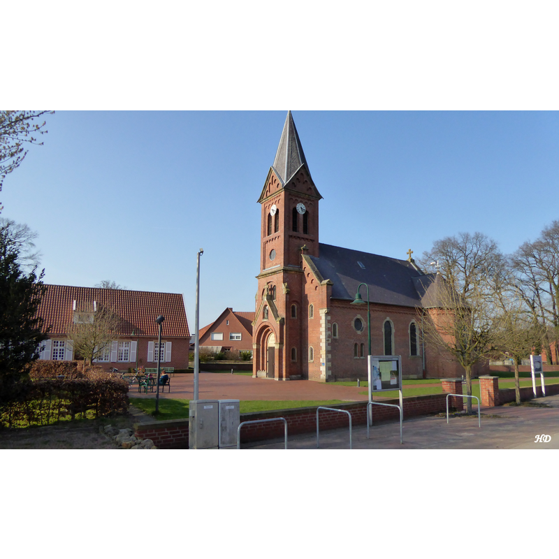
Image copyright © Heribert Duling (Famduling), 2017
GFDL / CC-BY-SA-4.0,3.0,2.5,2.0,1.0
Results: 2 records
view of church exterior in context - southwest view
Scene Description: Source caption: "Die Abt St. Antonius Kirche in Engden" -- the present 1899 church replaced an earlier chapel on the same site
Copyright Statement: Image copyright © Heribert Duling (Famduling), 2017
Image Source: digital photograph 28 March 2017 by Heribert Duling (Famduling) [https://commons.wikimedia.org/wiki/File:Engden_-_Abt_St.Antonius_Kirche.JPG] [accessed 10 August 2023]
Copyright Instructions: GFDL / CC-BY-SA-4.0,3.0,2.5,2.0,1.0
view of font in context

Scene Description: Source caption: "Von hier ging es in Meinerings Garten, denn hier steht ein Becken aus Sandstein, das einem Taufbecken ähnelt. Hier wird vermutet, dass es sich um das ehemalige Taufbecken aus der früheren Kapelle handelt. Einige der Teilnehmenden fanden den alten Taufstein schöner als den, der in der Antoniuskirche steht."
Copyright Statement: Image copyright © Heimatverein Engden, 2019
Image Source: digital photograph 10 June 2019 in Heimatverein Engden [https://www.heimatverein-schuettorf.de/engden/] [accessed 10 August 2023][https://www.heimatverein-schuettorf.de/wp-content/uploads/2022/06/Taufstein-in-Meinerings-Garten.jpeg] [accessed 10 August 2023]
Copyright Instructions: PERMISSION NOT AVAILABLE -- IMAGE NOT FOR PUBLIC USE
INFORMATION
Font ID: 24886ENG
Object Type: Baptismal Font1
Font Century and Period/Style: 14th - 17th century
Church / Chapel Name: Katholische Kirche Abt St. Antonius
Font Location in Church: Located in a nearby garden
Church Patron Saint(s): St. Anthony the Great [aka Antony the Great, Anthony the Abbot, Anthony of the Desert, Anthony the Anchorite, Anthony of Thebes]
Church Notes: present church of 1899 replaced an earlier chapel demolished that same year
Church Address: Dorfstraße 18, 48465 Engden, Germany -- Tel.: +49 5903 93100
Site Location: Bentheim, Niedersachsen, Germany, Europe
Directions to Site: Located off local road K5 [aka Nodhorner Str.], 6 km W of the A30 and A31, between Nordhorn (WNW) and Schüttorf (SSE), about 35 km NE of Enschede
Ecclesiastic Region: Bistum Osnabrück
Additional Comments: disused font (now a planter in a nearby garden)
Font Notes:
Click to view
An entry in Heimatverein Engden [https://www.heimatverein-schuettorf.de/engden/] [accessed 10 August 2023] relates a 10 June 2019 visit that reached the Meinering's garden, in which is a vessel believed to have been the baptismal font of the demolished chapel that was replaced in 1899 by the present church; a comment was made about liking this font better than the one introduced in the new church in 1899 ["Von hier ging es in Meinerings Garten, denn hier steht ein Becken aus Sandstein, das einem Taufbecken ähnelt. Hier wird vermutet, dass es sich um das ehemalige Taufbecken aus der früheren Kapelle handelt. Einige der Teilnehmenden fanden den alten Taufstein schöner als den, der in der Antoniuskirche steht."] The present font in the re-built church is modern, presumably of 1899.
Credit and Acknowledgements: We are grateful to Pol Herman for bringing this font to our attention and for his help in documenting it
COORDINATES
UTM: 32U 375712 5806143
Latitude & Longitude (Decimal): 52.391411, 7.173507
Latitude & Longitude (DMS): 52° 23′ 29.08″ N, 7° 10′ 24.62″ E
MEDIUM AND MEASUREMENTS
Material: stone, sandstone
Font Shape: octagonal, mounted
Basin Exterior Shape: octagonal