Velika Nedelja
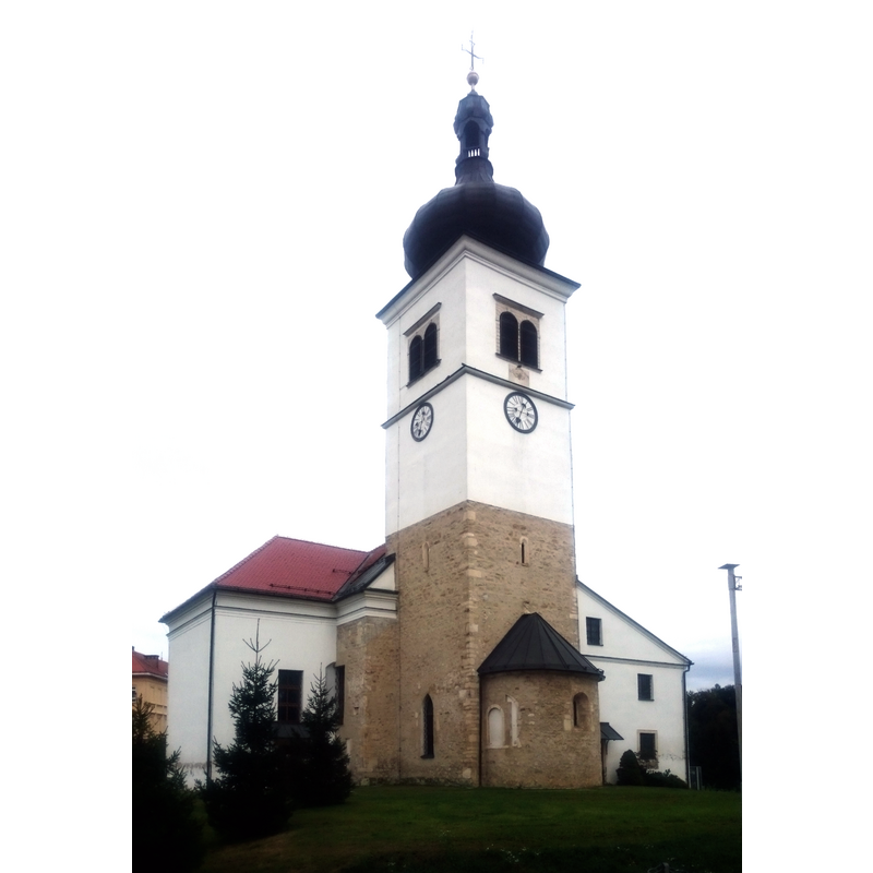
Image copyright © Ajznponar, 2020
CC-BY-SA-4.0
Results: 7 records
view of church exterior - east view
Scene Description: Source caption: "Cerkev sv. Trojice v Veliki Nedelji."
Copyright Statement: Image copyright © Ajznponar, 2020
Image Source: edited detail of a digital photograph 26 September 2020 by Ajznponar [https://commons.wikimedia.org/wiki/File:Velika_Nedelja,_Holy_Trinity_parish_church_04.jpg] [accessed 3 April 2023]
Copyright Instructions: CC-BY-SA-4.0
view of church exterior - northwest view
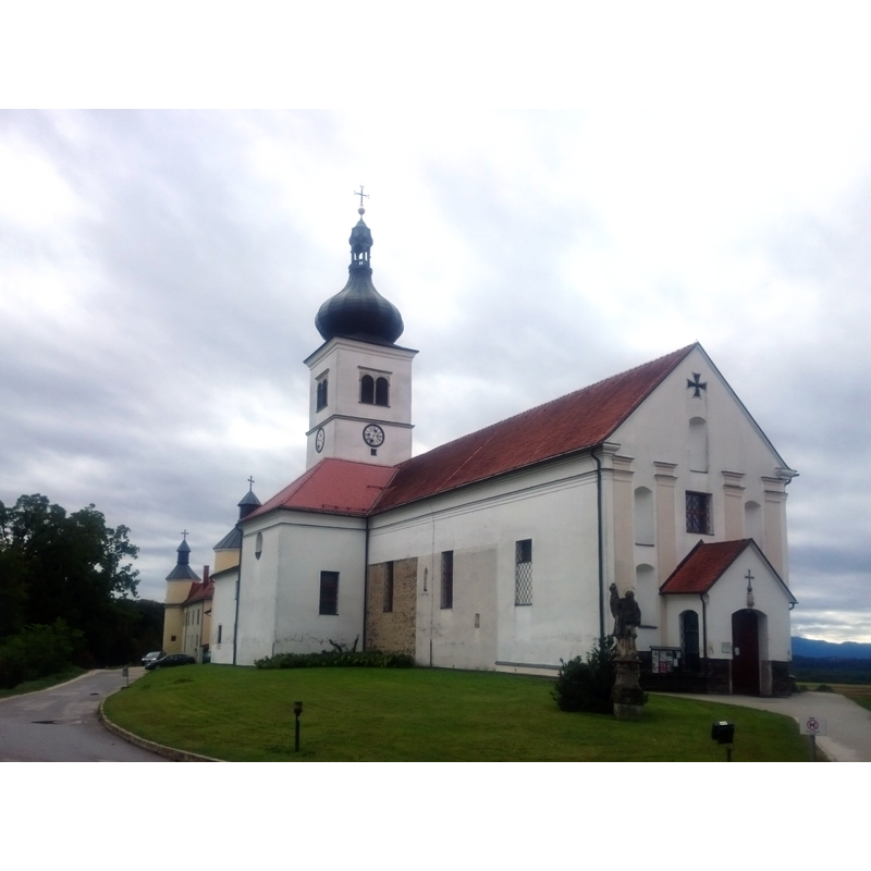
Scene Description: Source caption: "Cerkev sv. Trojice v Veliki Nedelji"
Copyright Statement: Image copyright © Ajznponar, 2020
Image Source: edited detail of a digital photograph 26 September 2020 by Ajznponar [https://commons.wikimedia.org/wiki/File:Velika_Nedelja,_Holy_Trinity_parish_church_02.jpg] [accessed 3 April 2023]
Copyright Instructions: CC-BY-SA-4.0
view of church exterior in context
![Source caption: "G. M. Vischers Käyserlichen Geographi, Topographia Ducatus Stiriae [...] Graz 1681"](/static-50478a99ec6f36a15d6234548c59f63da52304e5/compressed/0230403011_compressed.png)
Scene Description: Source caption: "G. M. Vischers Käyserlichen Geographi, Topographia Ducatus Stiriae [...] Graz 1681"
Copyright Statement: Image copyright © [in the public domain]
Image Source: digital image by Hubertl (2012) of a 1681 engraving in G. M. Vischers Käyserlichen Geographi, Topographia Ducatus Stiriae [https://commons.wikimedia.org/wiki/File:Vischer_-_Topographia_Ducatus_Stiria_-_140_Groß-Sonntag_bei_Friedau_-_Velika_Vedelja.jpg] [accessed 3 April 2023]
Copyright Instructions: CC-PD-Mark / CPB-Scan from Austria
view of font

Copyright Statement: Image copyright © Katholische Kirche Kärnten, 2023
Image Source: digital image in Katholische Kirche Kärnten [https://www.kath-kirche-kaernten.at/images/slideshows/11078/imag1499__xxlarge.jpg] [accessed 3 April 2023]
Copyright Instructions: PERMISSION NOT AVAILABLE -- IMAGE NOT FOR PUBLIC USE
human figure - head - 4
Scene Description: set at 90-degree angles bwlow the upper rim
Copyright Statement: Image copyright © ORFKärnten, 2018
Image Source: digital image 13 January 2018 in ORF Kärnten [https://kaernten.orf.at/v2/tv/stories/2888726/] [accessed 3 April 2023]
Copyright Instructions: PERMISSION NOT AVAILABLE -- IMAGE NOT FOR PUBLIC USE
view of basin - upper view
Scene Description: Source caption: "Im ältesten Teil des Gotteshauses befindet sich das Becken aus Marmor aus dem Phorje-Gebirge aus dem Jahr 1273. Es gilt als ältestes Taufbecken Sloweniens."
Copyright Statement: Image copyright © ORFKärnten, 2018
Image Source: digital image 13 January 2018 in ORF Kärnten [https://kaernten.orf.at/v2/tv/stories/2888726/] [accessed 3 April 2023]
Copyright Instructions: PERMISSION NOT AVAILABLE -- IMAGE NOT FOR PUBLIC USE
view of church interior - looking east
Scene Description: Source caption: "Velika Nedelja - Church of the Holy Trinity - Interior of the church"
Copyright Statement: Image copyright © Kraji, 2023
Image Source: edited detail of a digital image in Kraji [https://kraji.eu/slovenija/velika_nedelja_cerkev_sv_trojice/photos/eng] [accessed 3 April 2023]
Copyright Instructions: PERMISSION NOT AVAILABLE -- IMAGE NOT FOR PUBLIC USE
INFORMATION
Font ID: 24650VEL
Object Type: Baptismal Font1
Font Date: 1273?
Font Century and Period/Style: 13th century (late?), Late Romanesque
Church / Chapel Name: Cerkev sv. Trojice v Veliki Nedelji [Holy Trinity Church]
Font Location in Church: Inside the church
Church Patron Saint(s): The Holy Trinity
Church Notes: said to have been built by the Teutonic Knights from an earlier chapel
Church Address: 2274 Velika Nedelja, Slovenia
Site Location: Styria, Slovenia, Europe
Directions to Site: Located off road 2, in the municipality and 3 km WNW of Ormož, 35-40 km ESE of Maribor
Ecclesiastic Region: [Diocese of Maribor]
Historical Region: Styria
Font Notes:
Click to view
The entry Taufbecken im Alpen-Adria-Raum in ORF Kärnten [https://kaernten.orf.at/v2/tv/stories/2888726/] [accessed 3 April 2023] notes and illustrates a baptismal font in the church at Velika Nedelja, a church built by the Teutonic Knights: "In Velika Nedelja, zu deutsch Groß-Sonntag, ließ der Deutsche Ritterorden aus einer Kapelle die Dreifaltigkeitskirche errichten"; the tub-shaped font was made of Phorje marble in the late-13th century: "Im ältesten Teil des Gotteshauses befindet sich das Becken aus Marmor aus dem Phorje-Gebirge aus dem Jahr 1273. Es gilt als ältestes Taufbecken Sloweniens."
COORDINATES
UTM: 33T 585422 5141188
Latitude & Longitude (Decimal): 46.418863, 16.111603
Latitude & Longitude (DMS): 46° 25′ 7.91″ N, 16° 6′ 41.77″ E
MEDIUM AND MEASUREMENTS
Material: stone, marble
Font Shape: tub-shaped
Basin Interior Shape: round
Basin Exterior Shape: round
Drainage Notes: lined