Strazeele / Stracelle / Stratsele / Strazele
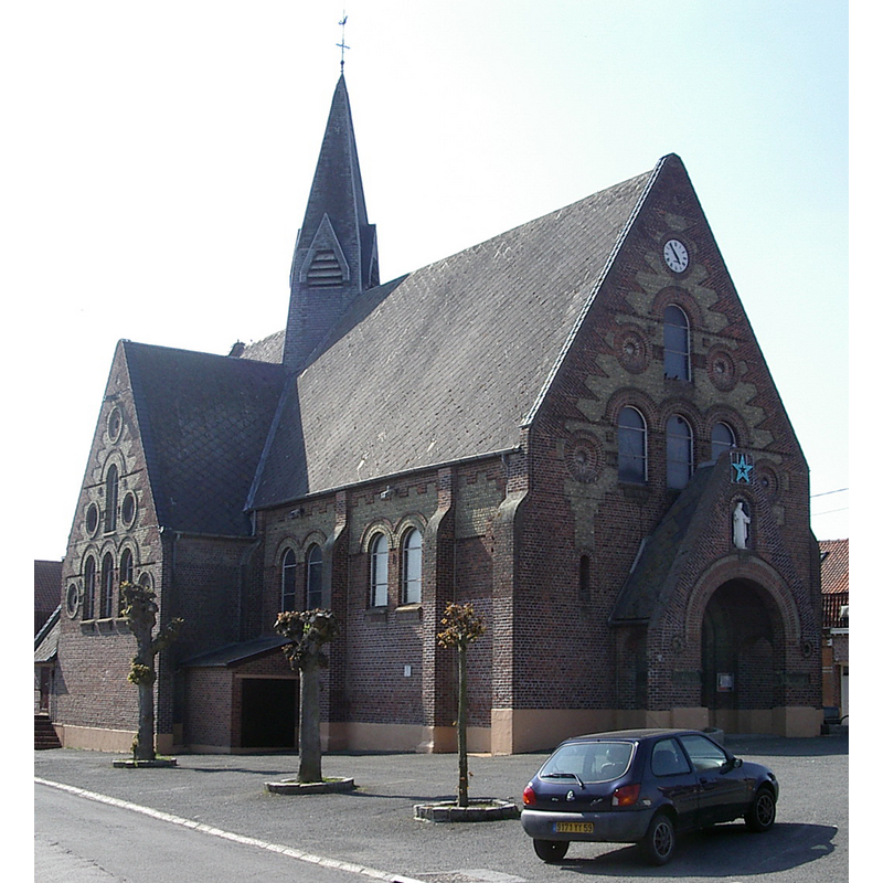
Image copyright © Codepem, 2009
GFDL / CC-BY-SA-3.0,2.5,2.0,1.0
Results: 2 records
view of church exterior - northwest view
Scene Description: Source caption: "Eglise Saint-Martin de Strazeele (Nord, France)" [NB: the new church]
Copyright Statement: Image copyright © Codepem, 2009
Image Source: edited detail of a digital photograph 10 February 2003 by Codepem [https://commons.wikimedia.org/wiki/File:Strazeele-02.JPG] [accessed 15 May 2022]
Copyright Instructions: GFDL / CC-BY-SA-3.0,2.5,2.0,1.0
view of church exterior - northwest view
![Source caption: "Ancienne église saint Martin de Strazeele (1916)" [NB: it would be destroyed with the rest of the village in 1918, during WWI]](/static-50478a99ec6f36a15d6234548c59f63da52304e5/compressed/1220515024_compressed.png)
Scene Description: Source caption: "Ancienne église saint Martin de Strazeele (1916)" [NB: it would be destroyed with the rest of the village in 1918, during WWI]
Copyright Statement: Image copyright © Patrimoine59, 2013
Image Source: digital image 24 December 2013 of a 1916 B&W photograph [original source not available] by Patrimoine59 [https://commons.wikimedia.org/wiki/File:Ancienne_église_de_strazeele_(1916).jpg] [accessed 15 May 2022]
Copyright Instructions: CC-BY-SA-3.0
INFORMATION
Font ID: 23961STR
Object Type: Baptismal Font1
Font Century and Period/Style: 15th century, Late Gothic
Church / Chapel Name: Église paroissiale Saint-Martin à Strazeele de Paroisse Notre-Dame-de-Grâce-en-Flandre
Font Location in Church: [cf. FontNotes]
Church Patron Saint(s): St. Martin of Tours
Church Notes: legendary chapel here 9thC; documented 15thC; damaged in mid-16thC riots; restored 1569; village and church destroyed 1918 in WWI; church re-built 1929;
Church Address: Ctr de l'Église, 59270 Strazeele, France -- Tel.: +33 6 04 43 67 93
Site Location: Nord, Hauts-de-France, France, Europe
Directions to Site: Located off the D642-D947 crossroads, W of the A25, 7 km E of Hazebrouck, about 30 km NW of Lille
Ecclesiastic Region: Diocèse de Lille
Historical Region: Nord-Pas-de-Calais / Flandre française / Pays de L'Alloeu
Additional Comments: destroyed font? [cf. FontNotes]
Font Notes:
Click to view
Noted in Kees de Wildt's Doopvont de Beeldenstorm (2018: 114-120) as possibly one of a number of baptismal fonts of the Westerkwartier (then part of Flanders, later in France) having been desecrated, damaged or destroyed during the Iconoclastic Fury of 1566. The church was destroyed in 1918, in WWI. [NB: we have no information on the date / period of the font destroyed(?) in the mid-16th century riots or in WWI].
Credit and Acknowledgements: We are grateful to Pol Herman for bringing this font to our attention and for his help in documenting it
COORDINATES
UTM: 31U 474021 5619643
Latitude & Longitude (Decimal): 50.728, 2.631917
Latitude & Longitude (DMS): 50° 43′ 40.8″ N, 2° 37′ 54.9″ E