Sailly-sur-la-Lys / Sailly-sur-Lys / Zelleken
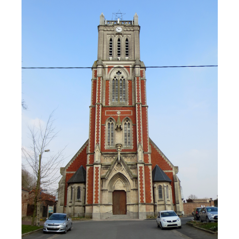
Image copyright © Herpoel, 2015
CC-BY-SA-4.0
Results: 2 records
view of church exterior - west view
Scene Description: Source caption: "L'église de Sailly-sur-la-Lys."] [NB: the new church was built to replace the building destroyed in WWI]
Copyright Statement: Image copyright © Herpoel, 2015
Image Source: digital photograph 14 March 2015 by Herpoel [https://commons.wikimedia.org/wiki/File:Saillysurlalys03.jpg] [accessed 13 May 2022]
Copyright Instructions: CC-BY-SA-4.0
view of church interior - southeast view
![Source caption: "The photograph and postcard is titled: La Guerre 1914-15-16. Sailly-Sur-La-Lys. Interieur de l'Eglise en ruines. Inside of the church in ruins. The photograph is glued to a page in Leo Bestall's diary and album." [NB: the church was totally destroyed in WWI; a new church was built to replace it in the 1920s]](/static-50478a99ec6f36a15d6234548c59f63da52304e5/compressed/0220513020_compressed.png)
Scene Description: Source caption: "The photograph and postcard is titled: La Guerre 1914-15-16. Sailly-Sur-La-Lys. Interieur de l'Eglise en ruines. Inside of the church in ruins. The photograph is glued to a page in Leo Bestall's diary and album." [NB: the church was totally destroyed in WWI; a new church was built to replace it in the 1920s]
Copyright Statement: Image copyright © [in the public domain]
Image Source: digital image of a B&W postcard A. Guéquière, Estaires (Nord), in the Collection of Hawke's Bay Museums [https://collection.mtghawkesbay.com/objects/91788/inside-church-ruins-sailly-sur-la-lys] [accessed 13 May 2022]
Copyright Instructions: PD
INFORMATION
Font ID: 23950SAI
Object Type: Baptismal Font1
Font Century and Period/Style: 11th - 12th century, Romanesque
Church / Chapel Name: Église paroissiale Saint-Vaast à Sailly-sur-la-Lys
Font Location in Church: [disappeared]
Church Patron Saint(s): St. Vedast [aka Foster, Vaast, Vedastus]
Church Notes: original church 11thC; documented 1310; partially destroyed 16thC; re-built thereafter; destroyed in WWI; re-built 1920s
Church Address: rue de l'Église, 62840 Sailly-sur-la-Lys, France -- Tel.: +33 3 21 27 64 53
Site Location: Pas-de-Calais, Hauts-de-France, France, Europe
Directions to Site: Located off the D166 [aka rue de l'Eglise], 4 km S of Steenwrck, 15 km NE of Béthune, 20 km WNW of Lille
Ecclesiastic Region: Diocese d'Arras
Historical Region: Nord-Pas-de-Calais / Flandre française / Pays de L'Alloeu
Additional Comments: disappeared / destroyed font? [cf. FontNotes]
Font Notes:
Click to view
Noted in Kees de Wildt's Doopvont de Beeldenstorm (2018: 114-120) as one of a number of baptismal fonts of the Westerkwartier (then part of Flanders, later in France) having been desecrated, damaged or destroyed during the Iconoclastic Fury of 1566. [NB: the re-built church was destroyed in WWI; we have no information on what date/period the fonts destroyed in 1566 or in WWI were]
Credit and Acknowledgements: We are grateful to Pol Herman for bringing this font to our attention and for his help in documenting it
COORDINATES
UTM: 31U 483602 5611976
Latitude & Longitude (Decimal): 50.6594, 2.76801
Latitude & Longitude (DMS): 50° 39′ 33.84″ N, 2° 46′ 4.84″ E