Holtum / Houtem
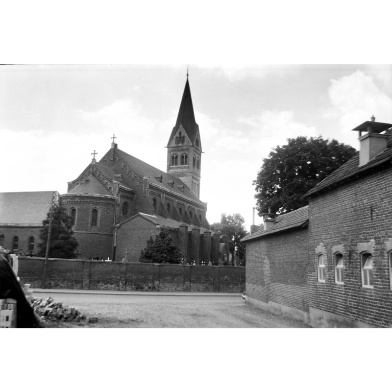
Image copyright © Rijksdienst voor het Cultureel Erfgoed, 2022
CC-BY-SA-4.0
Results: 8 records
view of church exterior in context - northeast view
Scene Description: Source caption: "Rooms-Katholieke Kerk: exterieur"
Copyright Statement: Image copyright © Rijksdienst voor het Cultureel Erfgoed, 2022
Image Source: digital image of a July 1971 B&W photograpj by H.P.R. Rosenberg, in the Rijksdienst voor het Cultureel Erfgoed [https://commons.wikimedia.org/wiki/File:Exterieur_-_Holtum_-_20114190_-_RCE.jpg] [accessed 25 February 2022]
Copyright Instructions: CC-BY-SA-4.0
view of church interior - looking east
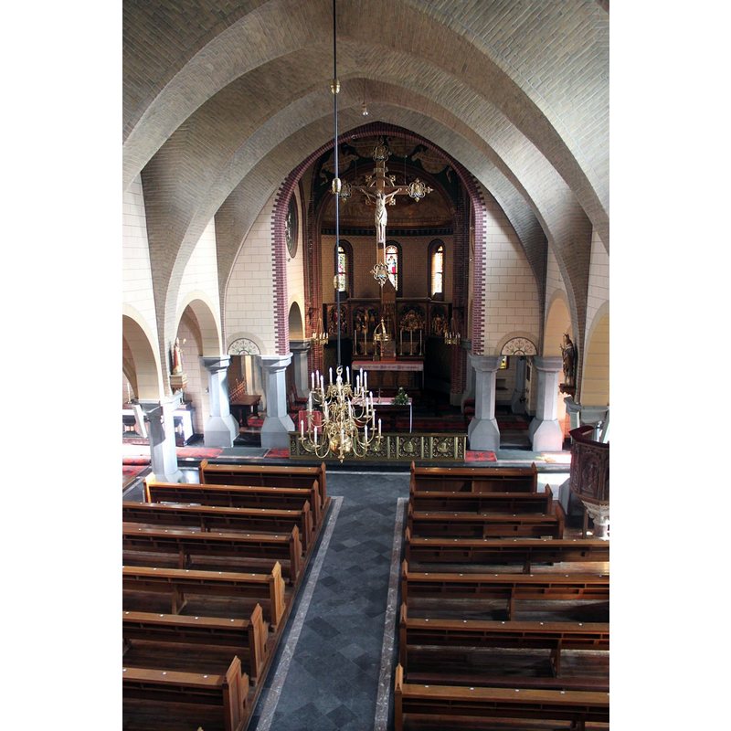
Copyright Statement: Image copyright © Michiel van 't Einde, 2014
Image Source: digital photograph February 2014 by Michiel van 't Einde, in Reliwiki [https://reliwiki.nl/index.php/Holtum,_Martinusstraat_3_-_Martinus] [accessed 25 February 2022]
Copyright Instructions: CC-BY-SA-4.0
inscription
![on the 1819 stoup [cf. FontNotes]](/static-50478a99ec6f36a15d6234548c59f63da52304e5/compressed/1260213051_compressed.png)
Scene Description: on the 1819 stoup [cf. FontNotes]
Copyright Statement: Image copyright © Parochiecomité H. Martinus Holtum, 2025
Image Source: digital image supplied by Mrs. Netty de Vries, secretary of the Parochiecomité H. Martinus Holtum
Copyright Instructions: Permission received via Pol Herman
view of stoup

Scene Description: the 1819 stoup
Copyright Statement: Image copyright © Parochiecomité H. Martinus Holtum, 2025
Image Source: digital image supplied by Mrs. Netty de Vries, secretary of the Parochiecomité H. Martinus Holtum
Copyright Instructions: Permission received via Pol Herman
inscription [cf. FontNotes]

Scene Description: on the 1643 stoup
Copyright Statement: Image copyright © Parochiecomité H. Martinus Holtum, 2025
Image Source: digital image supplied by Mrs. Netty de Vries, secretary of the Parochiecomité H. Martinus Holtum
Copyright Instructions: Permission received via Pol Herman
view of stoup

Scene Description: the1643 stoup
Copyright Statement: Image copyright © Parochiecomité H. Martinus Holtum, 2025
Image Source: digital image supplied by Mrs. Netty de Vries, secretary of the Parochiecomité H. Martinus Holtum
Copyright Instructions: Permission received via Pol Herman
information
![[cf. FontNotes]](/static-50478a99ec6f36a15d6234548c59f63da52304e5/compressed/1260213047_compressed.png)
Scene Description: [cf. FontNotes]
Copyright Statement: Image copyright © Parochiecomité H. Martinus Holtum, 2025
Image Source: digital image of a church record supplied by Mrs. Netty de Vries, secretary of the Parochiecomité H. Martinus Holtum
Copyright Instructions: Permission received via Pol Herman
information
![[cf. FontNotes]](/static-50478a99ec6f36a15d6234548c59f63da52304e5/compressed/1260213046_compressed.png)
Scene Description: [cf. FontNotes]
Copyright Statement: Image copyright © Parochiecomité H. Martinus Holtum, 2025
Image Source: digital image of a church record supplied by Mrs. Netty de Vries, secretary of the Parochiecomité H. Martinus Holtum
Copyright Instructions: Permission received via Pol Herman
INFORMATION
Font ID: 23787HOL
Object Type: Stoup
Font Date: 1643
Font Century and Period/Style: 17th century (mid)
Church / Chapel Name: Rooms-katholiek Parochiekerk Sint-Martinus
Font Location in Church: [cf. FontNotes]
Church Patron Saint(s): St. Martin of Tours
Church Notes: 13thC(?) church; tower added 1418; church demolished 1887-1888; re-built; expanded 1936; 1944 damaged in WWII; restored thereafter and again in 1985-1986 -- listed [Monumentnummer: 9915]
Church Address: Martinusstraat 3, 6123 BT Holtum, Netherlands
Site Location: Limburg, Netherlands, Europe
Directions to Site: Located off (W) the A2 / E25, in the municipality of Sittard-Geleen, just E of the border with Belgium, about 35 km NNE of Maastricht
Additional Comments: disappeared font (the one from ca.1200) -- price of a stoup: 5 guilders and 18 pennies in 1643
Font Notes:
Click to view
The entry for this church in Reliwiki [https://reliwiki.nl/index.php/Holtum,_Martinusstraat_3_-_Martinus] [accessed 25 February 2022] reports a baptismal font base of ca.1200, a limestone stoup of 1643 and a second stoup of 1819 in this church [="Tot de inventaris behoren o.a. de voet van een romaans doopvont plm 1200, een hardstenen wijwatervat, 1643 en een wijwatervat, 1819."]
A communication to BSI from Pol Herman (e-mail of 13 February 2026) informs that the base of the font is documented as missing in the 1977 inventory [cf.ImagesArea]; he further notes and documents the presence of two holy-water stoups in this church: one of 1643 inscribed "JOHANES PERBOMS 1643", the churchwarden Johanes Perbaums; the related church document states the price paid for the object at the time -- the second stoup also bears an inscription "PAULSSEN" and dates from 1819: "The base of the romanesque font is lost. (e-mail by Mrs. Netty de Vries, secretary of the Parochiecomité H. Martinus Holtum on 10th of February 2025). References : book “ Sint-Martinus ter ere (Het kerkelijk verleden van Holtum)”. As you see in “Noten 1”, the foot of the font was mentioned in literature in 1877 and in 1926. But Rouwet does not mention it anymore in his inventory in 1977. Probably lost by then. [pictures of stoups from 1643 and 1819 attached]. As the inscription mentions, the stoup of 1643 was donated by churchwarden Johanes Perboms. The invoice is preservered : supply costs for object one stoup 5 guilders and 18 pennies. As the inscription mention, the stoup of 1819 was donated by Paulssen."
A communication to BSI from Pol Herman (e-mail of 13 February 2026) informs that the base of the font is documented as missing in the 1977 inventory [cf.ImagesArea]; he further notes and documents the presence of two holy-water stoups in this church: one of 1643 inscribed "JOHANES PERBOMS 1643", the churchwarden Johanes Perbaums; the related church document states the price paid for the object at the time -- the second stoup also bears an inscription "PAULSSEN" and dates from 1819: "The base of the romanesque font is lost. (e-mail by Mrs. Netty de Vries, secretary of the Parochiecomité H. Martinus Holtum on 10th of February 2025). References : book “ Sint-Martinus ter ere (Het kerkelijk verleden van Holtum)”. As you see in “Noten 1”, the foot of the font was mentioned in literature in 1877 and in 1926. But Rouwet does not mention it anymore in his inventory in 1977. Probably lost by then. [pictures of stoups from 1643 and 1819 attached]. As the inscription mentions, the stoup of 1643 was donated by churchwarden Johanes Perboms. The invoice is preservered : supply costs for object one stoup 5 guilders and 18 pennies. As the inscription mention, the stoup of 1819 was donated by Paulssen."
COORDINATES
UTM: 31U 697888 5659024
Latitude & Longitude (Decimal): 51.048611, 5.823333
Latitude & Longitude (DMS): 51° 2′ 55″ N, 5° 49′ 24″ E
INSCRIPTION
Inscription Language: letters & numbers
Inscription Location: on the basin side
Inscription Text: "JOHANES PERBOMS 1643"
Inscription Notes: [cf. FontNotes]
Inscription Source: [cf. FontNotes]