Heeze / Héésj
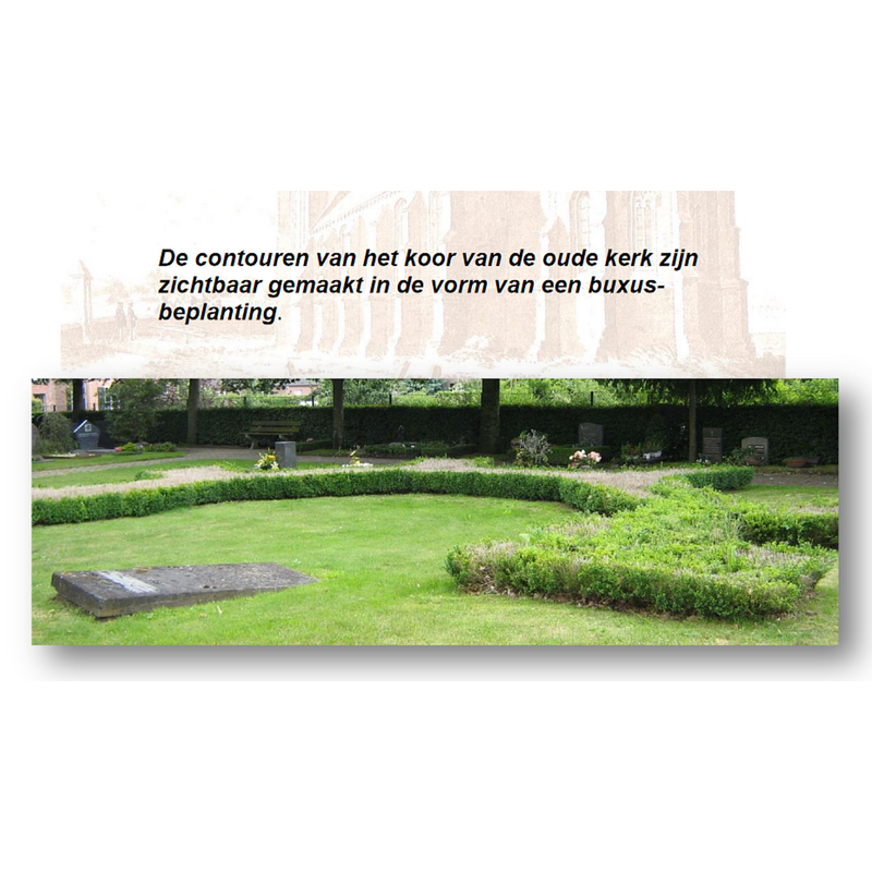
Image copyright © W.L.P. Coolen / Op den Rösheuvel, 2012-2018
No known copyright restriction / Fair Dealing
Results: 2 records
view of church exterior in context
Scene Description: Source caption: "De contouren van het koor van de oude kerk zijn zichtbaar gemaakt in de vorm van een buxus-beplanting."
Copyright Statement: Image copyright © W.L.P. Coolen / Op den Rösheuvel, 2012-2018
Image Source: digital image in Op den Rösheuvel [http://www.opdenrosheuvel.nl/pdf-regio/Heeze Oude Kerkhof versie 2018-1.pdf] [accessed 18 December 2021]
Copyright Instructions: No known copyright restriction / Fair Dealing
view of church exterior in context
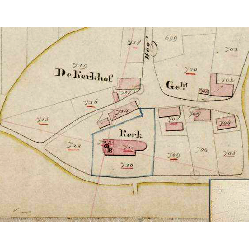
Scene Description: the church would be demolished in 1828, its tower in 1854
Copyright Statement: Image copyright © Erfgoed Wiki, 2021
Image Source: digital image of a [1832?] map in Eerste parochiekerk van Heeze [https://www.erfgoedgeowiki.nl/index.php/Eerste_parochiekerk_van_Heeze] [accessed 18 December 2021]
Copyright Instructions: CC-BY-SA-4.0
INFORMATION
Font ID: 23600HEE
Object Type: Baptismal Font1
Font Century and Period/Style: Medieval
Cognate Fonts: similar to the font at Lage-Mierde [now in Sint-Oedenrode]?
Church / Chapel Name: [Oude Sint-Martinus en Sint-Agatha Kerk Heeze? -- demolished 1828]
Font Location in Church: [cf. FontNotes]
Church Patron Saint(s): [old church dedicated to St. Martin & St. Agatha]
Church Notes: possible wooden chapel since 8thC; later [12th-13thC?] stobe church dedicated to Sint-Martinus en Sint-Agatha, a “halve kerk” with status of "ecclesia"
Church Address: [address of the site of the disappeared church] Kerkhof, Holeweg, 5591 LT Heeze, Netherlands
Site Location: Noord-Brabant, Netherlands, Europe
Directions to Site: The site is located E of highway A2, in the municipality of Heeze-Leende, 8-9 km SE of Eindhoven
Additional Comments: disappeared font (last seen/reported 1855 in a nearby farm) / disused and re-cycled font (used as water trough)
Font Notes:
Click to view
Begraafplaats De Oude Kerkhof Heeze [https://www.erfgoedgeowiki.nl/index.php/Begraafplaats_De_Oude_Kerkhof_Heeze] [accessed 18 December 2021] informs that the medieval church of Heeze, Reformed since 1648, had been abandoned by the Protestant community in favour of a chapel closer to the village, soon falling into disrepair; after its being sold to the Roman Catholic community it was demolished in 1828 (except for the tower) and its materials used in the construction of a new RC church in the village; the tower was demolished in turn in 1852. A source supplied by Pol Herman to BSI (e-mail of 7 December 2021), Petrus Norbertus Panken te Heeze en Leende by Drs.H.Mandos, in Heemkronijk (1964, jaargang 3, nummer 3, pages 40-45) reported that Schoolmaster Panken from Bergeijk (1819-1904) visited Heeze together with his cousin on Wednesday, August 22, 1855. After an overnight stay in the hotel 'In den Jager' in the Kapelstraat, the two visited the castle of Heeze in the morning where they were shown around by one of the young ladies. He noted in his diary: We made this visit to the castle between eight and ten o'clock, and half an hour later we left the village along the site of the church tower, which had been demolished in 1852, and which indicated a great age. The cemetery there now serves only for the burial of the corpses of the Protestant Congregation. An astonishing mass of rubble still lays from the tower. Living near this churchyard is the farmer P. Smulders, where I saw a medieval baptismal font, of blue limestone, most probably from the old parish church which had long since been demolished, about whose size, shape, etc. I then made some inquiries. This font is now used as a pump trough. Its diameter is 0.9 cubit, the thickness of the walls is 1 palm, the depth, measured inside 3 and outside 4 palms. Pol Herman adds that the font has not been heard of since.
A further communication from Pol Herman to BSI (e-mail of 9 February 2022) adds: the author of Handelingen van het provinciaal genootschap van Kunsten en Wetenschappen in Noordbrabant, over het jaar 1859, ’s Hertogenbosch, Gebroeders Muller, Uitgevers van het Genootschap, 1859, reports a letter from Peter Norbertus Panken, dated 4th of October 1856, in which Panken writes that he has encountered a font similar to Lage-Mierde at Heeze: "Te Heeze, bij Leende, zo schrijft mij Panken verder, bij P. Smulders, nabij de standplaats der oude Parochiekerk, zag ik in augustus van het voorgaande jaar de bak, in alles nagenoeg op dien van Lage-Mierde gelijkend, die hem tot pompbak diende."
A further communication from Pol Herman to BSI (e-mail of 9 February 2022) adds: the author of Handelingen van het provinciaal genootschap van Kunsten en Wetenschappen in Noordbrabant, over het jaar 1859, ’s Hertogenbosch, Gebroeders Muller, Uitgevers van het Genootschap, 1859, reports a letter from Peter Norbertus Panken, dated 4th of October 1856, in which Panken writes that he has encountered a font similar to Lage-Mierde at Heeze: "Te Heeze, bij Leende, zo schrijft mij Panken verder, bij P. Smulders, nabij de standplaats der oude Parochiekerk, zag ik in augustus van het voorgaande jaar de bak, in alles nagenoeg op dien van Lage-Mierde gelijkend, die hem tot pompbak diende."
Credit and Acknowledgements: We are grateful to Pol Herman for his help in documenting this font
COORDINATES
UTM: 31U 679407 5695012
Latitude & Longitude (Decimal): 51.368974, 5.556802
MEDIUM AND MEASUREMENTS
Material: stone, limestone
Trapezoidal Basin: [cf. FontNotes]