Biezelinge
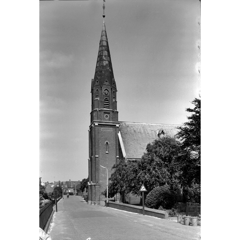
Image copyright © Rijksdienst voor het Cultureel Erfgoed, 2021
CC-BY-SA-4.0
Results: 2 records
view of church exterior - southwest end
Scene Description: Source caption: "Nederlands Hervormde Kerk: toren - Kapelle-Biezelinge, Biezelingestraat 67 - Gereformeerde Kerk" -- the modern church that replaced the earlier one demolished in 1907
Copyright Statement: Image copyright © Rijksdienst voor het Cultureel Erfgoed, 2021
Image Source: digital image of an August 1964 B&W photograoh by Gerard Dukker, in the Rijksdienst voor het Cultureel Erfgoed [https://commons.wikimedia.org/wiki/File:Toren_-_Biezelinge_-_20034844_-_RCE.jpg] [accessed 7 December 2021]
Copyright Instructions: CC-BY-SA-4.0
view of church exterior in context
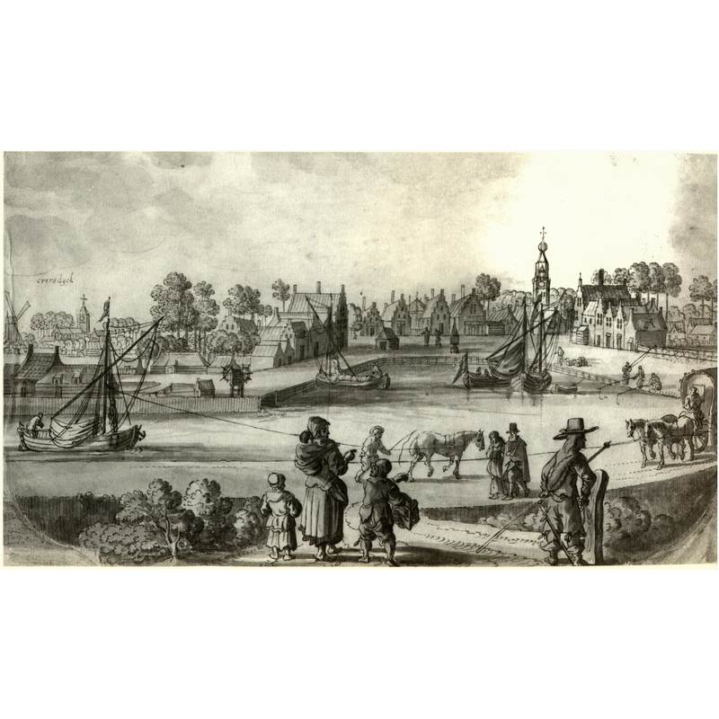
Scene Description: Source caption: "Prent van Biezelinge; voorbeeld voor de kopergravure in de "Speculum Zelandiæ""
Copyright Statement: Image copyright © [in the public domain]
Image Source: digital image of a 1650 print from a copper engraving by Visscher in Speculum Zelandiæ [https://commons.wikimedia.org/wiki/File:Zs31_Bieselinge¹.JPG] [accessed 7 December 2021]
Copyright Instructions: CC-PD-Mark
INFORMATION
Font ID: 23587BIE
Object Type: Baptismal Font1?
Font Date: ca. 1500?
Font Century and Period/Style: 15th - 16th century, Late Gothic
Church / Chapel Name: Hervormde Kerk / Mozeskerk [originally from the church demolished in 1907]
Font Location in Church: [cf. FontNotes]
Church Address: Marktplein 20, Biezelinge, 4421 JP Kapelle, Netherlands
Site Location: Zeeland, Netherlands, Europe
Directions to Site: Located off (N) the N289 and the A58, in the municipality and 1 km S of Kapelle, 5 km ESE of Goes
Additional Comments: two disappeared fonts? [cf. FontNotes]
Font Notes:
Click to view
We have no information on the late-medieval two fonts of Biezelinge. Information on the two fonts is contained in De ontvoering van een doopvont in Biezelinge [=The kidnapping of the baptismal font of Biezelinge], by Jan J.B. Kuipers, Provinciale Zeeuwse Courant, 4th of August 2021, and in Het vijfhonderdjarig jubileum van Rederijkerskamer De Wijngaardranke te Kapelle, by Frank de Klerk, Tijdschriftenbank Zeeland, De Spuije, 1st of March 2009. An English language version of the eventful history was provided by Pol Herman to BSI in a 1 December 2001 email: "Biezelinge originated as a settlement on a dam in a creek, which is today the Hoofdstraat, and possibly dates back to the 11th century. Farms had been built on the dam, one of which was found during an excavation in 1997. In the 12th century, the dam was incorporated into the large ring dyke of Zuid-Beveland that made a sharp bend inland specifically for this purpose. Later this inland bay will become the harbour of Biezelinge. The now dammed up creek continued inland for centuries in the form of the Molenwater that continued up to Kapelle. Under the care of the lords Maalstede, a distinguished nunnery was established in Biezelinge in 1426, called the young women's monastery Jerusalem. In the 15th and early 16th century, the village developed prosperously. Houses and businesses were being built on the harbour dikes and a local chapel and a weekly market were created at the harbour. Around 1500, Biezelinge has twice the number of inhabitants as Kapelle. But Kapelle still was the religious and administrative centre and the necessary money for this was earned in Biezelinge. The religious community of Biezelinge was chained to the church of Kapelle like a satellite. It had no other infrastructure than a village chapel.The chapel was extended in 1459 into a place of worship with a tower with annexed baptistery, and two choirs.
The kidnapping of the baptismal font of Biezelinge. It was a theft that caused a sensation. In the early spring of 1508, at night, lord Hendrik van Bruelis appeared with armed men at the recently completed baptistery of Biezelinge. They broke in, dragged out the brand new marble baptismal font, and took this outlandish trophy to Hendrik Bruelis’s Castle at Kapelle. It was a temporary low in a protracted conflict. In 1459, the chapel of the flourishing harbour town of Biezelinge had been greatly expanded. The inhabitants of Biezelinge wanted their own parish, separate from the mother church in Kapelle. But over there, people were vehemently against the desired split. Not in the least because in 1503, the wealthy families Maalstede, Bruelis, Gistellis and Poucques founded a chapter of ten canons and a dean in Kapelle, who graced the worship services, among other things. This not only led to a deepening of the spiritual life, but it cost a lot of money, which is one of the reasons why Kapelle wanted to keep prosperous Biezelinge as a source of income. In Biezelinge they claimed to have papal permission for their own church. A man from Biezelinge is said to have worked at the papal court around 1470 as a groom or cook. And he was apparently an influential servant. Due to his merits, the Biezelinge parish foundation was established in a papal bull, which was given to a woman. However, she drowned on her way to the Netherlands and the bull was never found. All these complications caused various disturbances around the beautiful and large chapel of Biezelinge on the current Noordstraat. Lord Hendrik van Bruelis sometimes acted threateningly. A parish foundation decision should not be based on the wishes of ordinary people, that constituted an odious innovation. Such initiatives belonged to the authorities. After the theft, the people of Biezelinge quickly installed another baptismal font. At the dedication of the chapel to Saint Barbara on April 29, 1508, grim villagers walked around armed with firearms, pikes, sticks, swords and bows. The consecration of the chapel into a parish church went smoothly. But delaying tactics and judicial procedures meant that the split was not ratified until 1529. Only for half a century could they enjoy their church and baptismal font. Then the Reformation changed everything. The parish of Biezelinge was again merged with Kapelle. The harbour silted up. An extensive salt marsh area was created along the Biezelingse Ham, so that the harbour is reclaimed for agricultural purposes in 1717. Economic activity then declines sharply. The late medieval church was demolished in 1907 and replaced by a new building. The cost of restoration was too high."
The kidnapping of the baptismal font of Biezelinge. It was a theft that caused a sensation. In the early spring of 1508, at night, lord Hendrik van Bruelis appeared with armed men at the recently completed baptistery of Biezelinge. They broke in, dragged out the brand new marble baptismal font, and took this outlandish trophy to Hendrik Bruelis’s Castle at Kapelle. It was a temporary low in a protracted conflict. In 1459, the chapel of the flourishing harbour town of Biezelinge had been greatly expanded. The inhabitants of Biezelinge wanted their own parish, separate from the mother church in Kapelle. But over there, people were vehemently against the desired split. Not in the least because in 1503, the wealthy families Maalstede, Bruelis, Gistellis and Poucques founded a chapter of ten canons and a dean in Kapelle, who graced the worship services, among other things. This not only led to a deepening of the spiritual life, but it cost a lot of money, which is one of the reasons why Kapelle wanted to keep prosperous Biezelinge as a source of income. In Biezelinge they claimed to have papal permission for their own church. A man from Biezelinge is said to have worked at the papal court around 1470 as a groom or cook. And he was apparently an influential servant. Due to his merits, the Biezelinge parish foundation was established in a papal bull, which was given to a woman. However, she drowned on her way to the Netherlands and the bull was never found. All these complications caused various disturbances around the beautiful and large chapel of Biezelinge on the current Noordstraat. Lord Hendrik van Bruelis sometimes acted threateningly. A parish foundation decision should not be based on the wishes of ordinary people, that constituted an odious innovation. Such initiatives belonged to the authorities. After the theft, the people of Biezelinge quickly installed another baptismal font. At the dedication of the chapel to Saint Barbara on April 29, 1508, grim villagers walked around armed with firearms, pikes, sticks, swords and bows. The consecration of the chapel into a parish church went smoothly. But delaying tactics and judicial procedures meant that the split was not ratified until 1529. Only for half a century could they enjoy their church and baptismal font. Then the Reformation changed everything. The parish of Biezelinge was again merged with Kapelle. The harbour silted up. An extensive salt marsh area was created along the Biezelingse Ham, so that the harbour is reclaimed for agricultural purposes in 1717. Economic activity then declines sharply. The late medieval church was demolished in 1907 and replaced by a new building. The cost of restoration was too high."
Credit and Acknowledgements: We are grateful to Pol Herman for his help in documenting these two missing fonts
COORDINATES
UTM: 31U 566828 5702995
Latitude & Longitude (Decimal): 51.474167, 3.962222
Latitude & Longitude (DMS): 51° 28′ 27″ N, 3° 57′ 44″ E