Kamperveen / Kampervene
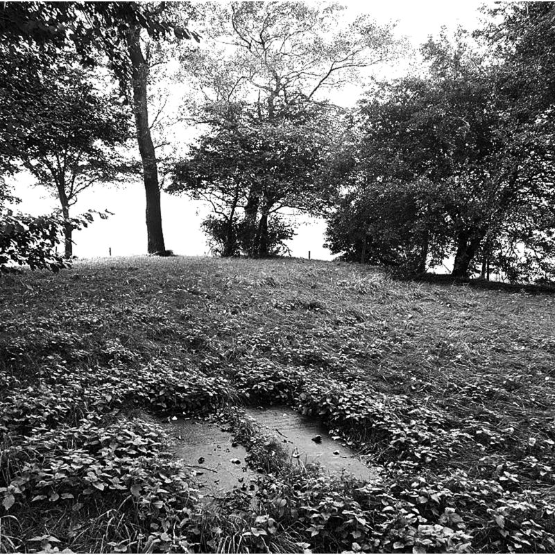
Image copyright © Rijksdienst voor het Cultureel Erfgoed, 2021
No known copyright restriction / Fair Dealing
Results: 1 records
view of church exterior - context
Scene Description: Source caption: " BEGRAAFPLAATS DE DOMPE" -- the photograph includes part of the site of the old church; the pair of stones seen here are tombstones located in the interior of the church; at a later date stones from the foundations were lined up marking the countour of the old church walls
Copyright Statement: Image copyright © Rijksdienst voor het Cultureel Erfgoed, 2021
Image Source: digital image of an 1 October 1987 B&W photograph by A.J. van der Wal, in the CARARE Collection, Rijksdienst voor het Cultureel Erfgoed [https://drimble.nl/cultuur/kamperveen/124065.html] [accessed 6 December 2021]
Copyright Instructions: No known copyright restriction / Fair Dealing
INFORMATION
Font ID: 23583KAM
Object Type: Baptismal Font1?
Font Century and Period/Style: Medieval
Church / Chapel Name: Oude Kamprveen Kerk [demolished]
Font Location in Church: [cf. FontNotes]
Church Notes: original church ca. 1330 ; replaced by new church in 1963 -- a YouTube video of the old church site [Begraafplaats de Dompe] [https://www.youtube.com/watch?v=C1yKR55gnF8]
Church Address: [coordinates are for the site of the old church] [address of the new church: Hogeweg 49, 8278 BC Kamperveen, Netherlands -- : +31 38 332 2608]
Site Location: Overijssel, Netherlands, Europe
Directions to Site: The site of the old church, Begraafplaats de Dompe, is located off the Leidijk and Dompeweg crossing, off the N50, 8-9 km W of Zwolle
Additional Comments: buried font? / fragment of a font? / disappeared font? [cf. FontNotes]
Font Notes:
Click to view
A description of the old church [demolished] claims that, among the ruins, is there is plinth or remains of the lower end of a baptismal font [ RUKSDIENST VOOR MET OUDHEIDKUNDIG BODEMONDERZOEK AMERSFOORT, JAARVERSLAG 1978]: Around 1330 Kamperveen had its own church building for the first time. This church was built on the Leidijk, next to the old cemetery "Dompe". According to some charters issued by the bishops Godfried van Rhenen (1156-1178), Otto I of Gelre (1212-1215), Wilbrand van Oldenburg (1227-1233) and Otto III of Holland (1234-1249), the agricultural development of the Kamperveen, stretching between Kampen and the village area of Zalk, on the left side of the IJssel, started hesitantly in the last quarter of the 12th century and was largely completed in the course of the 13th century. Kamperveen must have been established as a separate parish between 1319 and 1336. According to Vroegindewey, who derived his data from two letters (1714 and 1717) from the State Archives, the church collapsed in 1714 due to a storm and was not rebuilt until 1719. The damage inflicted during the December flood of 1747 was such that it was considered preferable to erect a new church elsewhere. This was completed in 1748 and it stood on the same site as the present Dutch Reformed Church. The old church was not rebuilt and now only a burial mound reminds of the place where the church once stood. In addition to the tower, the cadastral minute plan from about 1830 also shows the outline of the Oude Kerk, from which the conclusion can be drawn that the church walls had not been completely demolished in 1747, but left standing to a certain height above ground level. The length of the church, without the tower, could be determined at approximately 28 meters, measured outside. The tower base will, however, have been constructed somewhat heavier than the measurements from about 1830 suggest - approximately 7.5 meters square, measured outside. The nave and choir were provided with buttresses. In the south-west corner of the nave a separate foundation was found, next to the entrance present there, which we would like to understand as the substructure of a baptismal font.
COORDINATES
UTM: 31U 698876 5821585
Latitude & Longitude (Decimal): 52.4989, 5.9149
Latitude & Longitude (DMS): 52° 29' 56.2" N, 5° 54' 53.5" E