Ostra Tunhem / Östra Tunhem
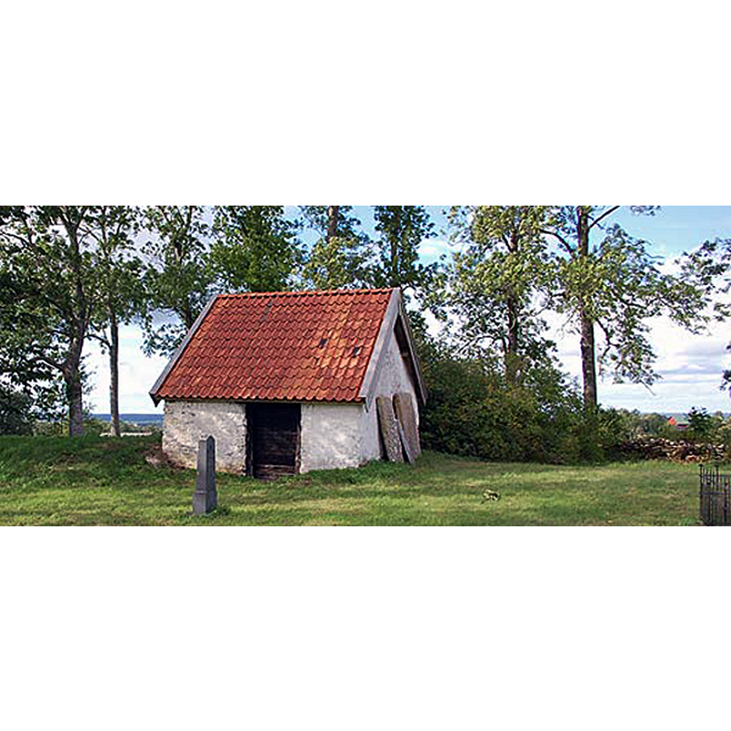
Image copyright © Bengans historiasidor, 2021
No known copyright restriction / Fair Dealing
Results: 6 records
view of church exterior in context - porch
Scene Description: the porch [vapenhuset] is all that remains of the old church; it was for a long time used as a cattle barn
Copyright Statement: Image copyright © Bengans historiasidor, 2021
Image Source: digital photograph by Bengans historiasidor [http://wadbring.com/historia/undersidor/tunhemo.htm] [accessed 21 March 2021]
Copyright Instructions: No known copyright restriction / Fair Dealing
view of church exterior - southwest view
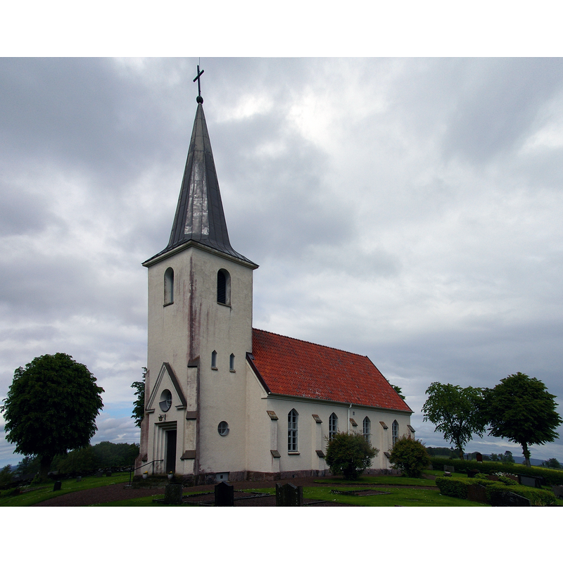
Scene Description: Source caption: "Östra Tunhems kyrka i Skara stift, Falköpings kommun. Uppförd 1949."
Copyright Statement: Image copyright © [in the public domain]
Image Source: edited detail of a digital photograph taken 20 June 2010 by Nasko [https://commons.wikimedia.org/wiki/File:Östra_Tunhems_kyrka_Västergötland_Sweden_3.jpg] [accessed 21 March 2021]
Copyright Instructions: PD-self
view of church exterior in context - southwest view
![Source caption: "Östra Tunhems kyrka [...] Kyrkan från sydväst." -- the new church had been built in 1900 on a new site; shown here in 1938, probably weeks or months before it was destroyed by fire](/static-50478a99ec6f36a15d6234548c59f63da52304e5/compressed/0210321011_compressed.png)
Scene Description: Source caption: "Östra Tunhems kyrka [...] Kyrkan från sydväst." -- the new church had been built in 1900 on a new site; shown here in 1938, probably weeks or months before it was destroyed by fire
Copyright Statement: Image copyright © [in the public domain]
Image Source: digital image [2893-007.tif] of a 1938 B&W photograph in the Kulturmiljöbild, Riksantikvarieämbetet [https://commons.wikimedia.org/wiki/File:Östra_Tunhems_kyrka_-_KMB_-_16001000013953.jpg] [accessed 21 March 2021]
Copyright Instructions: PD Sweden
view of church exterior - southeast view
![Source caption: "Östra Tunhems kyrka [...] Kyrkan från syd. Tryck efter teckning av Ernst Wennerblad, 1902." -- the new church had been built in 1900 on a new site; it would be destroyed by fire in 1938 and re-built in 1946-1949](/static-50478a99ec6f36a15d6234548c59f63da52304e5/compressed/0210321010_compressed.png)
Scene Description: Source caption: "Östra Tunhems kyrka [...] Kyrkan från syd. Tryck efter teckning av Ernst Wennerblad, 1902." -- the new church had been built in 1900 on a new site; it would be destroyed by fire in 1938 and re-built in 1946-1949
Copyright Statement: Image copyright © [in the public domain]
Image Source: digital image [2893-004.tif] of a 24 March 1902 drawing by Ernst Wennerblad, in the Kulturmiljöbild, Riksantikvarieämbetet [https://commons.wikimedia.org/wiki/File:Östra_Tunhems_kyrka_-_KMB_-_16001000013950.jpg] [accessed 21 March 2021]
Copyright Instructions: PD Sweden
view of church exterior
![Source caption: "Östra Tunhems kyrka [...] Kyrkan från syd. Foto efter teckning ur P.A. Säve: Berättelse för år 1863 (s. 54, A.T.A.)." -- the medieval church is said to have been much dilapidated already by the 16thC; it would eventually be demolished in 1887 except for the porch [vapenhus] (visible here between the belfry and the body of the church) which was used as a cattle barn](/static-50478a99ec6f36a15d6234548c59f63da52304e5/compressed/0210321009_compressed.png)
Scene Description: Source caption: "Östra Tunhems kyrka [...] Kyrkan från syd. Foto efter teckning ur P.A. Säve: Berättelse för år 1863 (s. 54, A.T.A.)." -- the medieval church is said to have been much dilapidated already by the 16thC; it would eventually be demolished in 1887 except for the porch [vapenhus] (visible here between the belfry and the body of the church) which was used as a cattle barn
Copyright Statement: Image copyright © [in the public domain]
Image Source: digital image [2893-003.tif] of a drawing in P.A. Säve: Berättelse för år 1863 (s. 54, A.T.A.), in the Kulturmiljöbild, Riksantikvarieämbetet [https://commons.wikimedia.org/wiki/File:Östra_Tunhems_kyrka_-_KMB_-_16001000013949.jpg] [accessed 21 March 2021]
Copyright Instructions: PD Sweden
view of church exterior - southeast view
![Source caption: "Östra Tunhems kyrka [...] Kyrkan från syd. Tryck efter teckning ur Peringskiölds monumenta." -- the medieval church is said to have been much dilapidated already by the 16thC; it would eventually be demolished in 1887 except for the porch [vapenhus], which was used as a cattle barn](/static-50478a99ec6f36a15d6234548c59f63da52304e5/compressed/0210321008_compressed.png)
Scene Description: Source caption: "Östra Tunhems kyrka [...] Kyrkan från syd. Tryck efter teckning ur Peringskiölds monumenta." -- the medieval church is said to have been much dilapidated already by the 16thC; it would eventually be demolished in 1887 except for the porch [vapenhus], which was used as a cattle barn
Copyright Statement: Image copyright © [in the public domain]
Image Source: digital image [2893-002.tif] of a late-17thC drawing in Peringskiöld's monumenta, in the Kulturmiljöbild, Riksantikvarieämbetet [https://commons.wikimedia.org/wiki/File:Östra_Tunhems_kyrka_-_KMB_-_16001000013948.jpg] [accessed 21 March 2021]
Copyright Instructions: PD Sweden
INFORMATION
Font ID: 23231TUN
Object Type: Baptismal Font1?
Font Century and Period/Style: 12th century, Romanesque
Church / Chapel Name: Östra Tunhems kyrka
Font Location in Church: [disappeared]
Church Notes: 12thC(?) church; reported dilapidated in the 16thC; condemned 1831 and abandoned while the congregation used nearby church at Ugglum; used as school until 1857; demolished 1887 except for the porch, which was used as a cattle barn; new church built 1900 on new site; destroyed by fire 1938; re-built 1946-1949;
Church Address: Östra Tunhems kyrkby, 521 94 Falköping, Sweden
Site Location: Västergötland, Västra Götalands län, Sweden, Europe
Directions to Site: Located off (W) tlocal road O2684, NW of highway 46, 7-8 km N of Falköping and in its municipality
Ecclesiastic Region: Skara stift
Historical Region: Gudhems härad
Additional Comments: disappeared font? (the one from the medieval church here)
Font Notes:
Click to view
The present font in use in this church is modern [NB: we have no information on the font of the medieval church]
COORDINATES
UTM: 33V 413687 6454624
Latitude & Longitude (Decimal): 58.2243, 13.5305
Latitude & Longitude (DMS): 58° 13′ 27.48″ N, 13° 31′ 49.8″ E