Caerwent No. 1 / Caer went / Venta Siluru / Venta Silurum
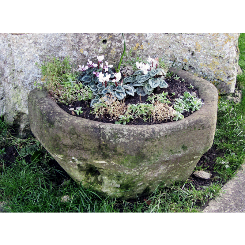
Image copyright © Colin Smith, 2020
Image and permission received from the author (e-mail of 13 September 2020)
Results: 4 records
view of basin
Scene Description: serving as planter outside the entranceway in March 2020
Copyright Statement: Image copyright © Colin Smith, 2020
Image Source: digital photograph taken 2 March 2020 ny Colin Smith
Copyright Instructions: Image and permission received from the author (e-mail of 13 September 2020)
view of basin in context
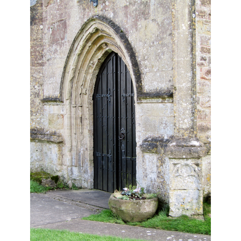
Scene Description: outside the entranceway in March 2020
Copyright Statement: Image copyright © Colin Smith, 2020
Image Source: digital photograph taken 2 March 2020 ny Colin Smith
Copyright Instructions: Image and permission received from the author (e-mail of 13 September 2020)
view of object
![one of two Roman srones that may have been used as base to the old font [cf. FontNotes]](/static-50478a99ec6f36a15d6234548c59f63da52304e5/compressed/1200913040_compressed.png)
Scene Description: one of two Roman srones that may have been used as base to the old font [cf. FontNotes]
Copyright Statement: Image copyright © Colin Smith, 2020
Image Source: digital photograph taken 2 March 2020 ny Colin Smith
Copyright Instructions: Image and permission received from the author (e-mail of 13 September 2020)
view of object
![one of two Roman srones that may have been used as base to the old font [cf. FontNotes]](/static-50478a99ec6f36a15d6234548c59f63da52304e5/compressed/1200913039_compressed.png)
Scene Description: one of two Roman srones that may have been used as base to the old font [cf. FontNotes]
Copyright Statement: Image copyright © Colin Smith, 2020
Image Source: digital photograph taken 2 March 2020 ny Colin Smith
Copyright Instructions: Image and permission received from the author (e-mail of 13 September 2020)
INFORMATION
Font ID: 22897CAE
Object Type: Baptismal Font1, basin only?
Font Century and Period/Style: 11th - 12th century, Norman
Church / Chapel Name: Parish Church of St. Stephen and St.Tathan [or St. Tathyw?]
Font Location in Church: Outside the church, by the entranceway
Church Patron Saint(s): St. Stephen & St. Tathan [aka Athan, Tathana] -or- [Tathyw?]
Church Notes: pre-10thC monastery; present church dated 13thC; restored 1893-94 and again 1910-12
Church Address: Pound Ln, Caerwent, Caldicot, NP26 5AY, UK
Site Location: Monmouthshire, Wales, United Kingdom
Directions to Site: Located off (S) the A48, W of the M48, 8 km WSW of Chepstow,16 km E of Newport, on the W shores of the Severn -- [Dinham is about 2 km N of Caerwent]
Ecclesiastic Region: Diocese of Monmouth (CofW)
Historical Region: Hundred of Is Coed, Gloucestershire
Additional Comments: disused font? altered font? / re-cut font (used as planter outside the main portal of the church
Font Notes:
Click to view
There is an entry for Caerwent in the Domesday survey [https://opendomesday.org/place/ST4690/caerwent/] [accessed 13 September 2020] but it mentions neither cleric nor church in it. Rees (2003) writes: "a Saxon font has an inverted Roman column for its base". The Archaeologia cambrensis (5th Series, vol. II, no. VIII, October 1885: 329) reports on a visit to the church "dedicated to St. Stephen", but no mention is made of any font in it; "There is a holy water stoup in the north wall, close by the door". The entry for this church in the CADW [http://cadwpublic-api.azurewebsites.net/reports/listedbuilding/FullReport?lang=en&id=2014] [accessed 13 September 2020] notes: "This church appears to be C13 in origin although a pre-Norman church is recorded at Caerwent, also a possible early Christian congregation during the Roman period; but there is no evidence that either of these shared the same site as the present church. [...] There are two fonts, only the first, that by the door, is native to this church. It is a re-cut Norman tub on a baluster pedestal, probably early C18 in its present form. The second font in the south aisle is also Norman in origin, but has been introduced to this church from the destroyed church at Dinham about 2 km to the north of Caerwent. It is a tub type on an unrelated plain base." It is possible that this re-cut Norman basin that lays now [March 2020] outside the main portal serving as a decorative planter, was used in past times mounted on one of the Roman pedestals retaing from the old Venta Silurum colony here; two such pedestals are still retained in this church [cf. ImagesArea]. [cf. BSI entry for Caerwent No. 2 for the font inow in use, originally from nearby Dinham]
Credit and Acknowledgements: We are grateful to Colin Smith for his photographs of this church and fonts
COORDINATES
UTM: 30U 516020 5717766
Latitude & Longitude (Decimal): 51.610703, -2.768651
Latitude & Longitude (DMS): 51° 36′ 38.53″ N, 2° 46′ 7.15″ W
MEDIUM AND MEASUREMENTS
Material: stone
Font Shape: octagonal, mounted
Basin Exterior Shape: round
Drainage Notes: no lining