Sieneskolan
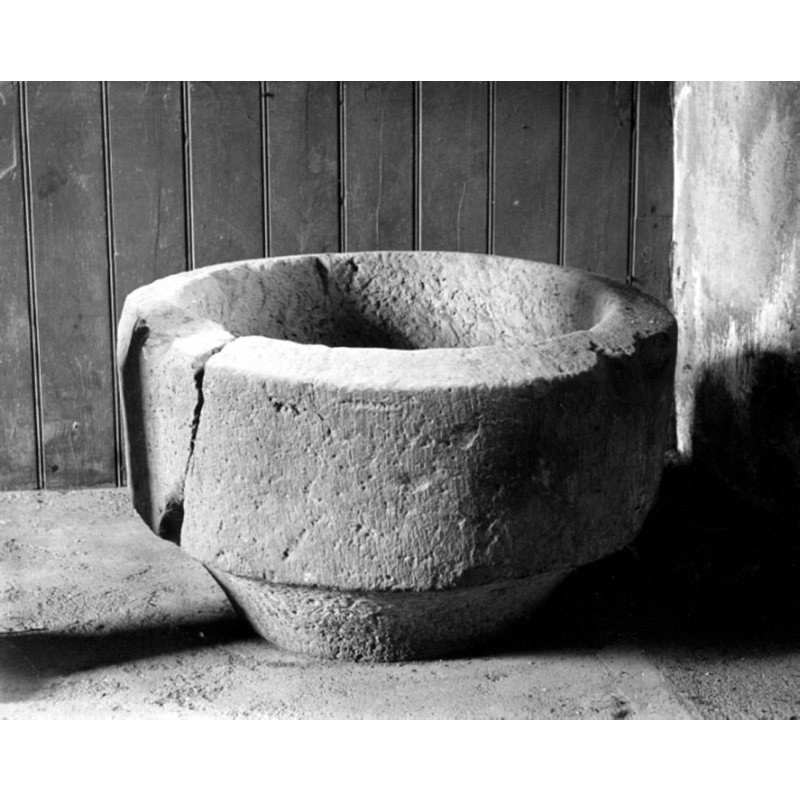
Image copyright © [in the public domain]
Public domain mark (CC pdm)
Results: 1 records
view of basin
Scene Description: Source caption: "Västergötland. Surteby-Kattunga sn. Kyrka. Del av dopfunt. Foto: Anders Roland. 1924."
Copyright Statement: Image copyright © [in the public domain]
Image Source: digital image [1M16-B145110:1275] of a 1924 B&W photograph by Anders Roland in the VGM Foto collection [1M16-B145110:1275 ], Västergötlands museum [https://digitaltmuseum.se/021017207811/vastergotland-surteby-kattunga-sn-kyrka-del-av-dopfunt-foto-anders-roland] [accessed 19 August 2020]:
Copyright Instructions: Public domain mark (CC pdm)
INFORMATION
Font ID: 22862SIE
Object Type: Baptismal Font1, basin only?
Font Date: ca. 1200?
Font Century and Period/Style: 12th - 13th century [basin only], Medieval / composite
Church / Chapel Name: [cf. FontNotes]
Font Location in Church: [reported in the porch at Surteby kyrka in 1966]
Church Address: [address and coordinates for Surteby kyrkby, Lundavägen, 519 94 Björketorp, Sweden -- Tel.: +46 320 604 45]
Site Location: Västergötland, Västra Götalands län, Sweden, Europe
Directions to Site: Surteby kyrka is located off (E) local road O1602 [aka Holmåkravägen], in the municipality of Mark
Additional Comments: moved font? [cf. FontNotes]
Font Notes:
Click to view
Hallbäck (1966) reports three fonts associated with the church at Surteby; of the three one is described as a plain cylindrical basin located in the porch [="vapenhuset"] at Surteby; it was made of sandstone ca. 1200 [="Den tillhör Sieneskolan och är tillverkad omkring 1200."] There is a 1924 B&W photograph of this font basin by Anders Roland in the VGM Foto collection [1M16-B145110:1275 ], Västergötlands museum [https://digitaltmuseum.se/021017207811/vastergotland-surteby-kattunga-sn-kyrka-del-av-dopfunt-foto-anders-roland] [accessed 19 August 2020]: the object has cylindrical sides with a short chanfer, all plain; it has a large through crack on one side; it lacks a base. [NB: we have no information on its present [August 2020] location].
COORDINATES
UTM: 33V 350964 6369265
Latitude & Longitude (Decimal): 57.441578, 12.516839
Latitude & Longitude (DMS): 57° 26′ 29.68″ N, 12° 31′ 0.62″ E
MEDIUM AND MEASUREMENTS
Material: stone, sandstone
Font Shape: cylindrical
Basin Interior Shape: round
Basin Exterior Shape: round
REFERENCES
- Hallbäck, Sven Axel, "Medeltida dopfuntar i Sjuhäradsbygden", Från Borås och de sju häradena 1966, 1966, p. 178-179