Gullered
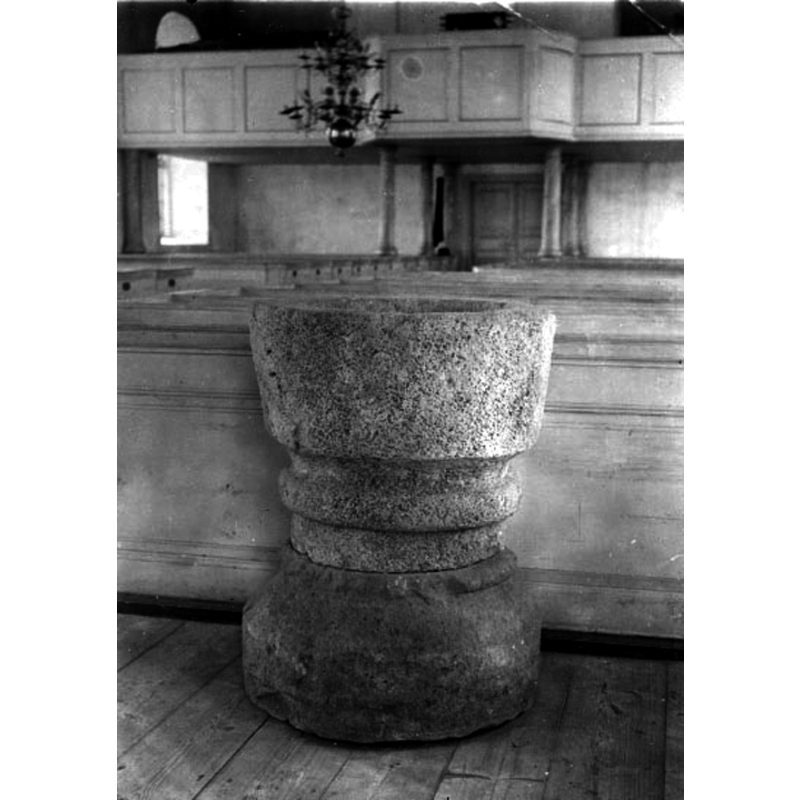
Image copyright © [in the public domain]
Public domain mark (CC pdm)
Results: 6 records
view of font in context
Scene Description: Source caption: "Gullered sn. Kyrkan, dopfunt.[...] Fotografering 1919, Fotograf Roland, Anders" [NB: this appears to be the mirror image of ImageFileNo.: 0200817011 -- one of the two must have been horizontally rotated from the negative by accident]
Copyright Statement: Image copyright © [in the public domain]
Image Source: digital image [1M16-B145110 1296] of a 1919 B&W photograph by Anders Roland, in the VGM Foto collection, Västergötlands museum [https://digitaltmuseum.se/021017207838/gullered-sn-kyrkan-dopfunt] [accessed 17 August 2020]
Copyright Instructions: Public domain mark (CC pdm)
view of font in context
![Source caption: "Gullereds kyrka [...] Dopfunt av sandsten, 1200-talet." -- [NB: this appears to be the mirror image of ImageFileNo.: 0200817012 -- one of the two must have been horizontally rotated from the negative by accident]](/static-50478a99ec6f36a15d6234548c59f63da52304e5/compressed/0200817011_compressed.png)
Scene Description: Source caption: "Gullereds kyrka [...] Dopfunt av sandsten, 1200-talet." -- [NB: this appears to be the mirror image of ImageFileNo.: 0200817012 -- one of the two must have been horizontally rotated from the negative by accident]
Copyright Statement: Image copyright © [in the public domain]
Image Source: digital image [2536-016.tif] of an undated [ca. 1919?] B&W photograph by Anders Roland, in the Kulturmiljöbild, Riksantikvarieämbetet [https://commons.wikimedia.org/wiki/File:Gullereds_kyrka_-_KMB_-_16000200156204.jpg] [accessed 17 August 2020]
Copyright Instructions: PD Sweden
design element - motifs - scotia-torus
Copyright Statement: Image copyright © [in the public domain]
Image Source: digital image [1M16-B145110 1296] of a 1919 B&W photograph by Anders Roland, in the VGM Foto collection, Västergötlands museum [https://digitaltmuseum.se/021017207838/gullered-sn-kyrkan-dopfunt] [accessed 17 August 2020]
Copyright Instructions: Public domain mark (CC pdm)
view of church exterior - northwest view
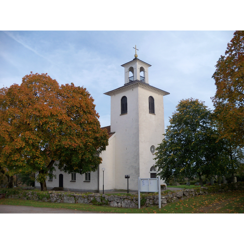
Copyright Statement: Image copyright © Iia62, 2011
Image Source: digital photograph taken 25 September 2011 by Iia62 [https://commons.wikimedia.org/wiki/File:Gullereds_kyrka.jpg] [accessed 17 August 2020]
Copyright Instructions: CC-BY-SA-3.0
view of church exterior - southeast view
![Source caption: "Gullereds kyrka [...] Kyrkan från sydöst, efter Ernst Wennerblads teckning, 1895."](/static-50478a99ec6f36a15d6234548c59f63da52304e5/compressed/0200817013_compressed.png)
Scene Description: Source caption: "Gullereds kyrka [...] Kyrkan från sydöst, efter Ernst Wennerblads teckning, 1895."
Copyright Statement: Image copyright © [in the public domain]
Image Source: digital image [2536-001.tif] of a 6 August 1895 drawing by Ernst Wennerblad, in the Kulturmiljöbild, Riksantikvarieämbetet [https://commons.wikimedia.org/wiki/File:Gullereds_kyrka_-_KMB_-_16000200156164.jpg] [accessed 17 August 2020]
Copyright Instructions: PD Sweden
view of font in context
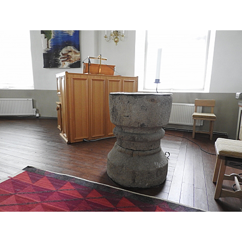
Scene Description: the medieval font inside the mid-19thC church, at the east end of the nave, south side
Copyright Statement: Image copyright © Carl-Johan Ivarsson, 2020
Image Source: digital photograph by Carl-Johan Ivarsson in Kyrkokartan.se [www.kyrkokartan.se/058230/images/58230_41906804] [accessed 17 August 2020]
Copyright Instructions: CC-BY-NC-SA-2.0
INFORMATION
Font ID: 22854GUL
Object Type: Baptismal Font1
Font Century and Period/Style: 12th - 13th century [composite font?], Medieval [composite]
Church / Chapel Name: Gullereds kyrka
Font Location in Church: Inside the new church, at the E end, S side
Church Notes: medieval wooden church demolished and replaced by new stone church in 1844; renovated several times in the 19thC;
Church Address: Gullered 103, 523 97 Ulricehamn, Sweden -- Tel.: +46 321 283 00
Site Location: Västergötland, Västra Götalands län, Sweden, Europe
Directions to Site: Located off (N) highway 40, 10-12 km E of Ulricehamn
Ecclesiastic Region: Skara stift
Historical Region: Redvägs härad
Additional Comments: altered font? / composite font [cf. FontNotes] / re-cycled font (moved from the oled church to the new) -- disappeared font? (the one from the ca. 1050 original wooden church here?)
Font Notes:
Click to view
Lagerlöf (1985) reports the demolition of the old wooden church here and the inauguration of a replacement church in 1844, some of which stone is said to have been taken from the old church at Tissered. Hallbäck (1966) reports a baptismal font of sandstone of the 13th century; the font is described as being of two blocks which may be unrelated, making this font a composite object. A 1919 photograph by Anders Roland [cf. ImagesArea] shows a stone font consisting of two blocks of clearly different stone; the upper block has a plain bucket-shaped basin followed down by a deep scotia and a pronounced roll moulding and a short vertical stem; no drainage hole; the lower block is circular with a patterned [rope?] moulting atop, then a chamfer and then a plain cylindrical end. There is no cover present.
COORDINATES
UTM: 33V 416471 6407323
Latitude & Longitude (Decimal): 57.800111, 13.594639
Latitude & Longitude (DMS): 57° 48′ 0.4″ N, 13° 35′ 40.7″ E
MEDIUM AND MEASUREMENTS
Material: stone, sandstone
Number of Pieces: two
Font Shape: bucket-shaped, mounted
Basin Interior Shape: round
Basin Exterior Shape: round
Drainage System: no drainage system
Drainage Notes: no lining
Font Height (less Plinth): 92 cm*
Notes on Measurements: * Hallbäck (1966)
REFERENCES
- Hallbäck, Sven Axel, "Medeltida dopfuntar i Sjuhäradsbygden", Från Borås och de sju häradena 1966, 1966, p. 80, 114, 152
- Lagerlöf, Erland, Medeltida träkyrkor II: Västergötland Värmland Närke, Stockholm: Riksantikvarieämbetet, 1985, p. 63