Stenstorp No. 3
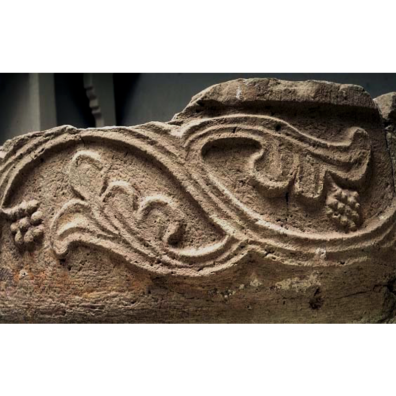
Image copyright © Statens Historiska Museum, 2003
CC-BY-NC-ND-4.0
Results: 6 records
design element - motifs - vine - acanthus or grapevine - bearing fruit
Scene Description: fragment of the basin of the medieval font originally from the demolished church of Brunnhem, later moved to Stenstorp -- Source caption: "Stenstorps kyrka [...] Dopfuntscuppa, medeltida. Funnen i jorden vid prästgården."
Copyright Statement: Image copyright © Statens Historiska Museum, 2003
Image Source: digital image of a photograph in Medeltidens bildvärld [ref.:
Copyright Instructions: CC-BY-NC-ND-4.0
view of basin - fragment
![fragment of the basin of the medieval font originally from the demolished church of Brunnhem, later moved to Stenstorp -- Source caption: "Stenstorps kyrka [...] Dopfuntscuppa, medeltida. Funnen i jorden vid prästgården."](/static-50478a99ec6f36a15d6234548c59f63da52304e5/compressed/0200707013_compressed.png)
Scene Description: fragment of the basin of the medieval font originally from the demolished church of Brunnhem, later moved to Stenstorp -- Source caption: "Stenstorps kyrka [...] Dopfuntscuppa, medeltida. Funnen i jorden vid prästgården."
Copyright Statement: Image copyright © [in the public domain]
Image Source: digital image [2869-015] of an undated B&W photograph in the Kulturmiljöbild, Riksantikvarieämbetet [https://commons.wikimedia.org/wiki/File:Stenstorps_kyrka_-_KMB_-_16000200167181.jpg] [accessed 7 July 2020]
Copyright Instructions: PD Sweden
view of basin in context
![fragment of the basin of the medieval font originally from the demolished church of Brunnhem, later moved to Stenstorp -- Source caption: "Stenstorps kyrka [...] Dopfuntscuppa, medeltida. Funnen i jorden vid prästgården."](/static-50478a99ec6f36a15d6234548c59f63da52304e5/compressed/0200707012_compressed.png)
Scene Description: fragment of the basin of the medieval font originally from the demolished church of Brunnhem, later moved to Stenstorp -- Source caption: "Stenstorps kyrka [...] Dopfuntscuppa, medeltida. Funnen i jorden vid prästgården."
Copyright Statement: Image copyright © [in the public domain]
Image Source: digital image [2869-013] of an undated B&W photograph in the Kulturmiljöbild, Riksantikvarieämbetet [https://commons.wikimedia.org/wiki/File:Stenstorps_kyrka_-_KMB_-_16000200167180.jpg] [accessed 7 July 2020]
Copyright Instructions: PD Sweden
view of church exterior in context
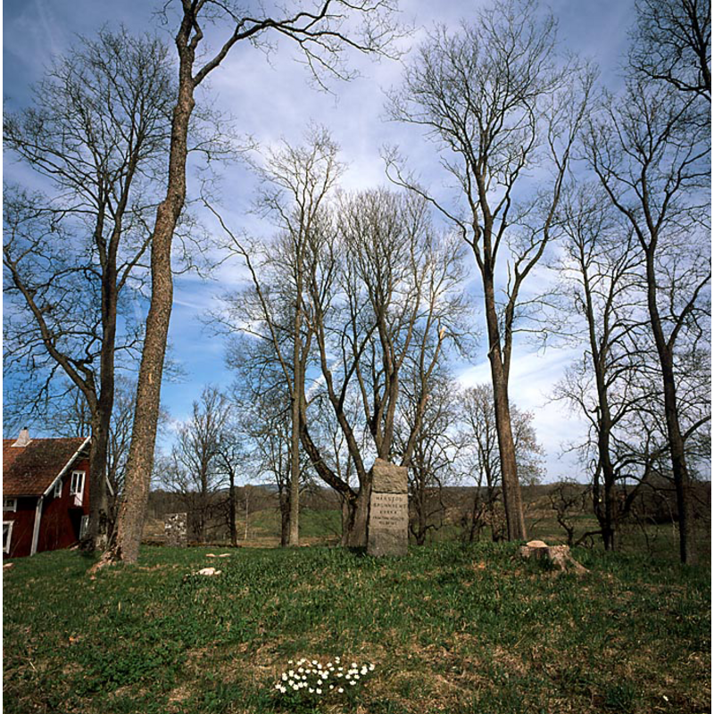
Scene Description: the stone in the centre of the image marks the site of the disappeared parish church of Brunnhem -- Source caption: " Brunnhems ödekyrkogård. Kyrkan revs på kunglig befallning år 1817. Foto från 2001"
Copyright Statement: Image copyright © Kyrkoruiner i Västergötland, 2001
Image Source: digital photograph taken in 2001, Kyrkoruiner i Västergötland [http://apachepersonal.miun.se/~akejohan/ruinervg.htm] [accessed 7 Ju;y 2020]
Copyright Instructions: No known copyright restriction / Fair Dealing
view of church exterior - churchyard, cemetery - gravestone
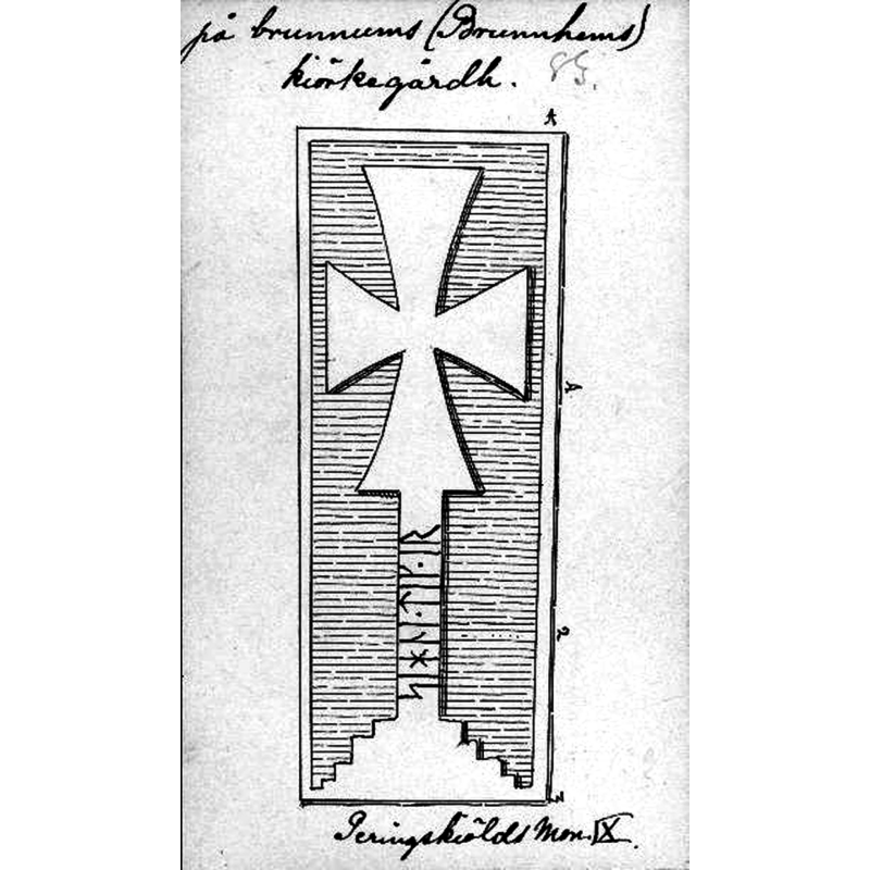
Scene Description: Source caption: "Gravsten på kyrkogården. Efter teckning ur Peringskiölds monumenta."
Copyright Statement: Image copyright © [in the public domain]
Image Source: digital image [9902-004.tif] of a late-17thC drawing in Peringskiöld's Monumenta, in the Kulturmiljöbild, Riksantikvarieämbetet [https://commons.wikimedia.org/wiki/File:Brunnhems_kyrkplats_-_KMB_-_16000200153096.jpg] [accessed 7 July 2020]
Copyright Instructions: PD Sweden
view of church exterior - southeast view
![Sourca caption: "Kyrkan och klockstapeln från söder. Foto efter teckning ur Peringskiölds monumenta." [NB: the image in the original Kulturmiljöbild, Riksantikvarieämbetet URL is reversed horizontally; the image we are showing here has been corrected accordingly]](/static-50478a99ec6f36a15d6234548c59f63da52304e5/compressed/0200707009_compressed.png)
Scene Description: Sourca caption: "Kyrkan och klockstapeln från söder. Foto efter teckning ur Peringskiölds monumenta." [NB: the image in the original Kulturmiljöbild, Riksantikvarieämbetet URL is reversed horizontally; the image we are showing here has been corrected accordingly]
Copyright Statement: Image copyright © [in the public domain]
Image Source: digital image [9902-001.tif] of a late-17thC drawing in Peringskiöld's Monumenta, in the Kulturmiljöbild, Riksantikvarieämbetet [https://commons.wikimedia.org/wiki/File:Brunnhems_kyrkplats_-_KMB_-_16000200153093.jpg] [accessed 7 July 2020]
Copyright Instructions: PD Sweden
INFORMATION
Font ID: 22787STE
Object Type: Baptismal Font1, fragment
Font Date: ca. 1200?
Font Century and Period/Style: 12th - 13th century, Romanesque
Church / Chapel Name: Stenstorp kyrka [originally from the demolished Brunnhems kyrka]
Font Location in Church: [cf. FontNotes]
Church Notes: medieval church at Stenstorp demolished early-19thC together with those at Brunnhem and Södra Kyrketorp; all three replaced with one new church in Sternstorp in 1817 -- information and photographs of the ruins site at Brunnhems kyrkplats [www.kyrkoruiner.se/brunnhem.php] [accessed 7 July 2020]
Church Address: [NB: address and coordinates given here are for Stenstorps kyrka] 521 61, Skolgatan 2, 521 61 Stenstorp, Sweden -- Tel.: +46 500 49 95 00
Site Location: Västergötland, Västra Götalands län, Sweden, Europe
Directions to Site: The site of the demolished church is off a small local road O2691 [aka Brunnhemsvägen] to the WNW of Stenstorp. The address and coordinates for the site are: Brunnhemsvägen, 521 63 Stenstorp, Sweden -- 58° 16′ 16.72″ N / 13° 41′ 46.8″ E / 58.271311 / 13.696333 / 33V 423528 6459657
Ecclesiastic Region: [Skara stift]
Historical Region: Gudhems härad
Additional Comments: disused font / fragment of a font / moved font / buried(?) font (originally from the demolished church of Brunnhem; later in a museum; later still in the newly-built church at Stenstorp)
Font Notes:
Click to view
Noted in Hallbäck (1971). A badly damaged fragment of a medieval basin believed to have originated in the demolishedc parish church of Brunnhem was dug up in the rectory garden at Stenstorp [see ImagesArea: digital image [2869-013] of an undated B&W photograph in the Kulturmiljöbild, Riksantikvarieämbetet [https://commons.wikimedia.org/wiki/File:Stenstorps_kyrka_-_KMB_-_16000200167180.jpg] [accessed 7 July 2020]. The fragment is noted and illustrated in the SHM Medeltidens bildvärld [ref.: 920507F4] entry for Stenstorp, noting that it was believed to have been originally from Brunnhem: "enligt lokal tradition kommer funten ursprungligen från Brunnhem"; the fragent is dated in the SHM to ca. 1200 and the material identified as sandstone.
COORDINATES
UTM: 33V 424211 6459264
Latitude & Longitude (Decimal): 58.2679, 13.7081
Latitude & Longitude (DMS): 58° 16′ 4.44″ N, 13° 42′ 29.16″ E
MEDIUM AND MEASUREMENTS
Material: stone, sandstone
Font Shape: round
Basin Interior Shape: round
Basin Exterior Shape: round
Drainage System: centre hole in basin
Drainage Notes: no lining
Diameter (includes rim): 69 cm*
Basin Total Height: 35 cm*
Notes on Measurements: * SHM Medeltidens bildvärld [ref.: 920507F4] [NB: all measurements are for the surviving fragment]
REFERENCES
- Hallbäck, Sven Axel, "Medeltida dopfuntar i Skaraborg", 1971-1972, Västergötlands Fornminnesförenings Tidskrift, 1971-1972, pp. 39-357; p. 330