Rada nr. Lidköping / Råda / Rådha
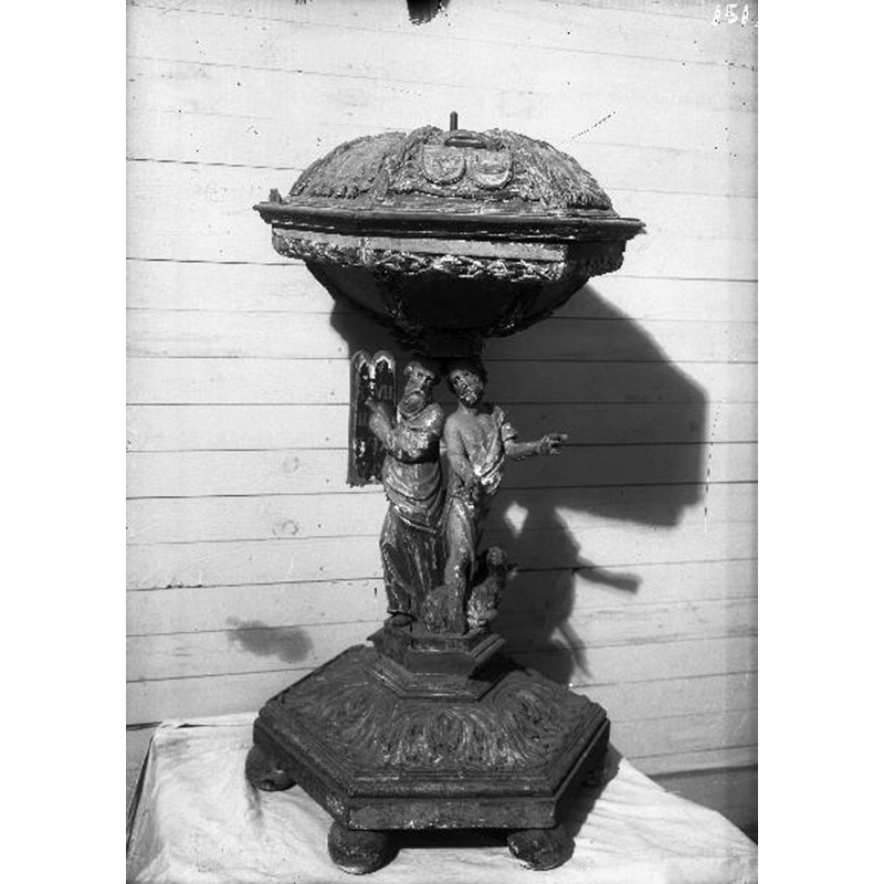
Image copyright © [in the public domain]
PD Sweden
Results: 8 records
view of font and cover
Scene Description: the wooden font of 1705
Copyright Statement: Image copyright © [in the public domain]
Image Source: digital image [2732-047.tif] of an undated B&W photograph in the Kulturmiljöbild, Riksantikvarieämbetet [https://commons.wikimedia.org/wiki/File:Råda_kyrka_-_KMB_-_16000200164346.jpg] [accessed 4 July 2020]
Copyright Instructions: PD Sweden
view of basin
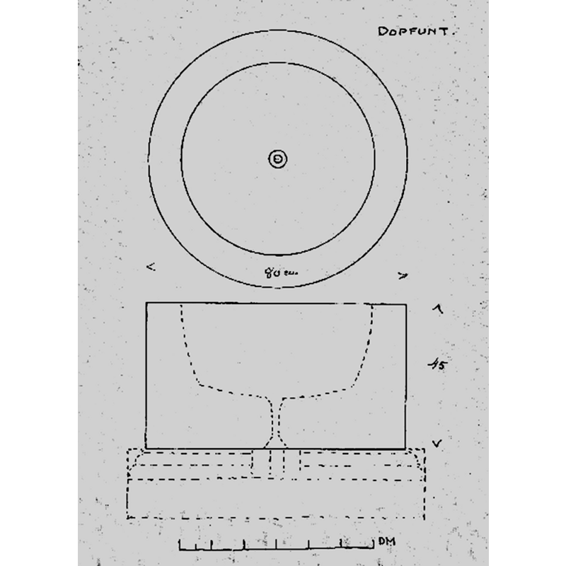
Scene Description: includes measurements for the outer diameter and height of the basin -- Source caption: "Dopfunt, sandsten, 1100-talet. Uppmätningsritning utförd av Anders Roland 1911."
Copyright Statement: Image copyright © [in the public domain]
Image Source: digital image [2732-043.tif] of a 1911 drawing by Anders Roland, in the Kulturmiljöbild, Riksantikvarieämbetet [https://commons.wikimedia.org/wiki/File:Råda_kyrka_-_KMB_-_16000200164342.jpg] [accessed 4 July 2020]
Copyright Instructions: PD Sweden
view of church exterior - detail
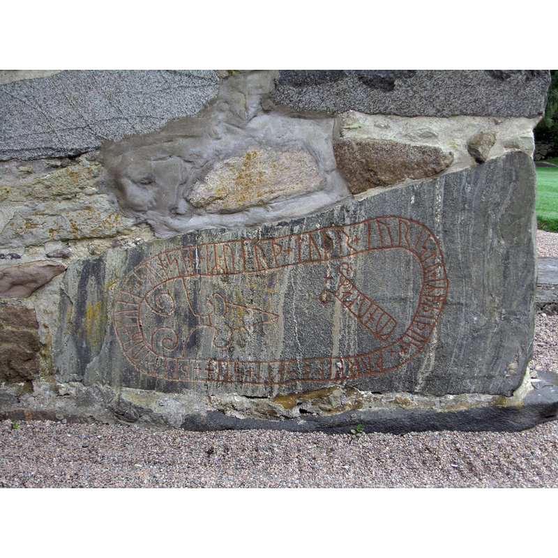
Scene Description: Source caption: "English: Runestone (Vg 40) in the wall of Råda church, Kålland, Sweden. Text: þurkil ÷ sati + stin + þasi + itiR + kuna + sun * sin + iR * uarþ + tuþr + i uristu + iR * bþiþus + kunukaR × Translation: Torkel erected this stone after his son Gunne. He fell in the battle when the kings fought.
It is not known which battle is referred to in the text. It may e.g be the battle of Svolder, or the battle of Helgeå.
Svenska: Runsten (Vg 40) inmurad i väggen på vapenhuset till Råda kyrka, Kålland. Text: þurkil ÷ sati + stin + þasi + itiR + kuna + sun * sin + iR * uarþ + tuþr + i uristu + iR * bþiþus + kunukaR × Översättning: Torkel satte denna sten efter sin son Gunne. Han stupade i striden då konungarna kämpade.
Okänt vilket slag som åsyftas. Det kan t.ex vara slaget vid Svolder (år 1000) eller slaget vid Helgeå."
Copyright Statement: Image copyright © Dagjoh, 2011
Image Source: digital photograph taken 26 July 2011 by Dagjoh [https://commons.wikimedia.org/wiki/File:Radakyrka3.jpg] [accessed 4 July 2020]
Copyright Instructions: CC-BY-SA-3.0
view of church exterior - north view
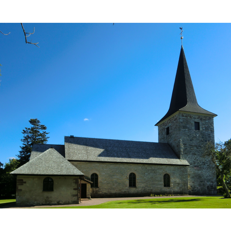
Copyright Statement: Image copyright © Dagjoh, 2011
Image Source: edited detail of a digital photograph taken 16 July 2011 by Dagjoh [https://commons.wikimedia.org/wiki/File:Radakyrka2.jpg] [accesed 4 July 2020]
Copyright Instructions: CC-BY-SA-3.0
view of church exterior - south view
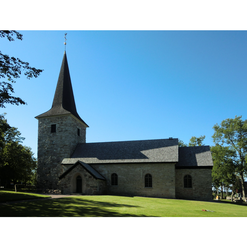
Copyright Statement: Image copyright © Dagjoh, 2011
Image Source: edited detail of a digital photograph taken 16 July 2011 by Dagjoh [https://commons.wikimedia.org/wiki/File:Radakyrka1.jpg] [accesed 4 July 2020]
Copyright Instructions: CC-BY-SA-3.0
view of basin in context
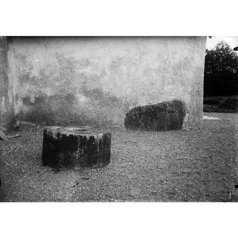
Scene Description: Source caption: "Dopfunt, sandsten, 1100-talet, samt runsten inmurad i ytterväggen."
Copyright Statement: Image copyright © [in the public domain]
Image Source: digital image [2732-044.tif] an undated B&W photograph by Anders Roland, in the Kulturmiljöbild, Riksantikvarieämbetet [https://commons.wikimedia.org/wiki/File:Råda_kyrka_-_KMB_-_16000200164343.jpg] [accessed 4 July 2020]
Copyright Instructions: PD Sweden
view of church exterior - southeast view
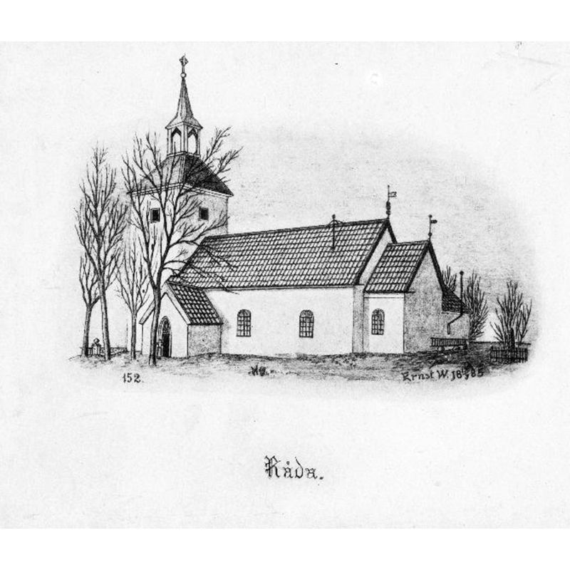
Scene Description: Source caption: "Kyrkan från sydöst. Tryck efter teckning av Ernst Wennerblad 1885."
Copyright Statement: Image copyright © [in the public domain]
Image Source: digital image [2732-006.tif] of a March 1885 drawing by Ernst Wennerblad, in the Kulturmiljöbild, Riksantikvarieämbetet [https://commons.wikimedia.org/wiki/File:Råda_kyrka_-_KMB_-_16000200164249.jpg] [accessed 4 July 2020]
Copyright Instructions: PD Sweden
view of church exterior - southeast view
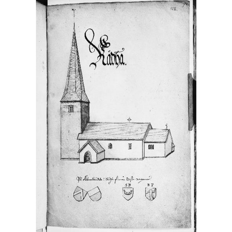
Scene Description: Source caption: "Kyrkan från sydöst. Foto efter teckning ur Peringskiölds Monumenta."
Copyright Statement: Image copyright © [in the public domain]
Image Source: digital image [2732-001.tif] of a late-17thC drawing in Peringskiöld's Monumenta, in the Kulturmiljöbild, Riksantikvarieämbetet [https://commons.wikimedia.org/wiki/File:Råda_kyrka_-_KMB_-_16000200164243.jpg] [accessed 4 July 2020]
Copyright Instructions: PD Sweden
INFORMATION
Font ID: 22782RAD
Object Type: Baptismal Font1, basin only
Font Century and Period/Style: 11th - 13th century [basin only], Medieval
Church / Chapel Name: Råda kyrka
Font Location in Church: [cf. FontNotes]
Church Notes: original church probably wooden, perhaps 11thC; re-built 12th and 13thC; tower added 15thC; modified since
Church Address: Råda kyrby, 531 96 Lidköping, Sweden
Site Location: Västergötland, Västra Götalands län, Sweden, Europe
Directions to Site: Located N of road 44, in the municipality and W outskirts of Lidköping
Ecclesiastic Region: Skara stift
Historical Region: Kållands härad / Skaraborgs län
Additional Comments: disused font (the basin of a medieval (?) font appears in an early photograph disused outside the church)
Font Notes:
Click to view
The present font in use is dated 1705 [cf. ImagesArea]. A polygonal [octagonal?] basin upturned and showing the drain hole appears in a 1911 photograph, disused outside the church, near the large Runic stone built into the outer wall. We have no information on its wehereabouts since 1911.
COORDINATES
UTM: 33V 388798 6485538
Latitude & Longitude (Decimal): 58.49623, 13.09207
Latitude & Longitude (DMS): 58° 29′ 46.43″ N, 13° 5′ 31.45″ E
MEDIUM AND MEASUREMENTS
Material: stone
Font Shape: octagonal
Basin Interior Shape: round
Basin Exterior Shape: octagonal
Drainage System: centre hole in basin
Diameter (includes rim): 80 cm*
Basin Total Height: 45 cm*
Notes on Measurements: * Anders Roland (1911) [cf. ImagesArea]