Gokhem No. 2 / Gochen / Göchen / Goekhem / Gökhem
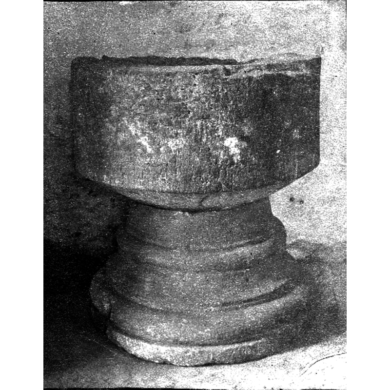
Image copyright © [in the public domain]
PD Sweden
Results: 9 records
view of font
Scene Description: Source caption: "Dopfunt, sandsten, skålen avslagen upptill, 1200-talet."
Copyright Statement: Image copyright © [in the public domain]
Image Source: digital image [2885-129.tif] of an 1893 B&W photograph in the Kulturmiljöbild, Riksantikvarieämbetet [https://commons.wikimedia.org/wiki/File:Gökhems_kyrka_-_KMB_-_16000200156577.jpg] [accessed 6 June 2020]
Copyright Instructions: PD Sweden
view of font in context
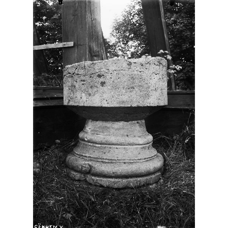
Scene Description: Source caption: "Dopfunt, sandsten, skålen avslagen upptill, 1200-talet." -- was the photograph taken during the 1913 restoration of the church?
Copyright Statement: Image copyright © [in the public domain]
Image Source: digital image [2885-134.tif] of an undated B&W photograph in the Kulturmiljöbild, Riksantikvarieämbetet [https://commons.wikimedia.org/wiki/File:Gökhems_kyrka_-_KMB_-_16000200156582.jpg] [accessed 6 June 2020]
Copyright Instructions: PD Sweden
view of font in context
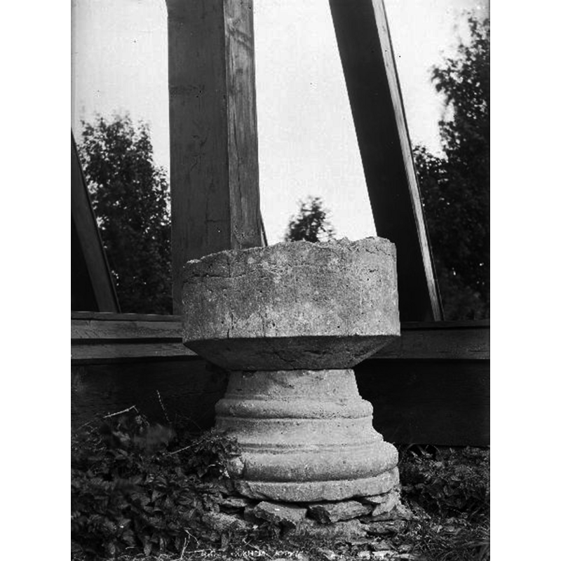
Scene Description: Source caption: "Dopfunt, sandsten, skålen avslagen upptill, 1200-talet." -- was the photograph taken during the 1913 restoration of the church?
Copyright Statement: Image copyright © [in the public domain]
Image Source: digital image [2885-132.tif] of an undated B&W photograph by Anders Roland, in the Kulturmiljöbild, Riksantikvarieämbetet [https://commons.wikimedia.org/wiki/File:Gökhems_kyrka_-_KMB_-_16000200156580.jpg] [accessed 6 June 2020]
Copyright Instructions: PD Sweden
view of church exterior in context - southeast view
![Source caption: "Överkyrke kyrkoruin i Gökhems socken, Vilske härad, Falköpings kommun, Västergötland, Sverige. Ruinen har beteckningen RAÄ-nummer Gökhem 44:1 i Fornminnesregistret. Överkyrke var en medeltida kyrka som låg endast 170 meter sydöst om Gökhems sockenkyrka.' -- [NB: not known whether one of the two fonts listed for Gökhem in BSi was originally from this abandoned church]](/static-50478a99ec6f36a15d6234548c59f63da52304e5/compressed/1200607011_compressed.png)
Scene Description: Source caption: "Överkyrke kyrkoruin i Gökhems socken, Vilske härad, Falköpings kommun, Västergötland, Sverige. Ruinen har beteckningen RAÄ-nummer Gökhem 44:1 i Fornminnesregistret. Överkyrke var en medeltida kyrka som låg endast 170 meter sydöst om Gökhems sockenkyrka.' -- [NB: not known whether one of the two fonts listed for Gökhem in BSi was originally from this abandoned church]
Copyright Statement: Image copyright © [in the public domain]
Image Source: digital photograph taken 15 April 2010 by Gunnar Creutz [https://commons.wikimedia.org/wiki/File:Överkyrke_kyrkoruin_i_Gökhems_socken.jpg] [accessed 7 June 2020]
Copyright Instructions: CC-Zero
view of church exterior - detail
![Source caption: "Ruinen av en romansk stenkyrka från 1100-talet, Överkyrke kallad, med torn och smalare rakslutet kor. Ruinen undersöktes 1955." -- [NB: showing the cleaning of the ruins of the medieval church in ruins; it is said to have been abandoned by the mid-16thC -- not known whether one of the two fonts listed for Gökhem in BSi was originally from this abandoned church]](/static-50478a99ec6f36a15d6234548c59f63da52304e5/compressed/0200607013_compressed.png)
Scene Description: Source caption: "Ruinen av en romansk stenkyrka från 1100-talet, Överkyrke kallad, med torn och smalare rakslutet kor. Ruinen undersöktes 1955." -- [NB: showing the cleaning of the ruins of the medieval church in ruins; it is said to have been abandoned by the mid-16thC -- not known whether one of the two fonts listed for Gökhem in BSi was originally from this abandoned church]
Copyright Statement: Image copyright © [in the public domain]
Image Source: digital image [1M16-B145048:791] of a 1956 B&W photograph by Elisabeth Ekelöf, in the VGM Foto collection, Västergötlands museum [https://digitaltmuseum.se/021017204428/ruinen-av-en-romansk-stenkyrka-fran-1100-talet-overkyrke-kallad-med-torn] [accessed 7 June 2020]
Copyright Instructions: Public domain mark (CC pdm)
view of church interior - plan
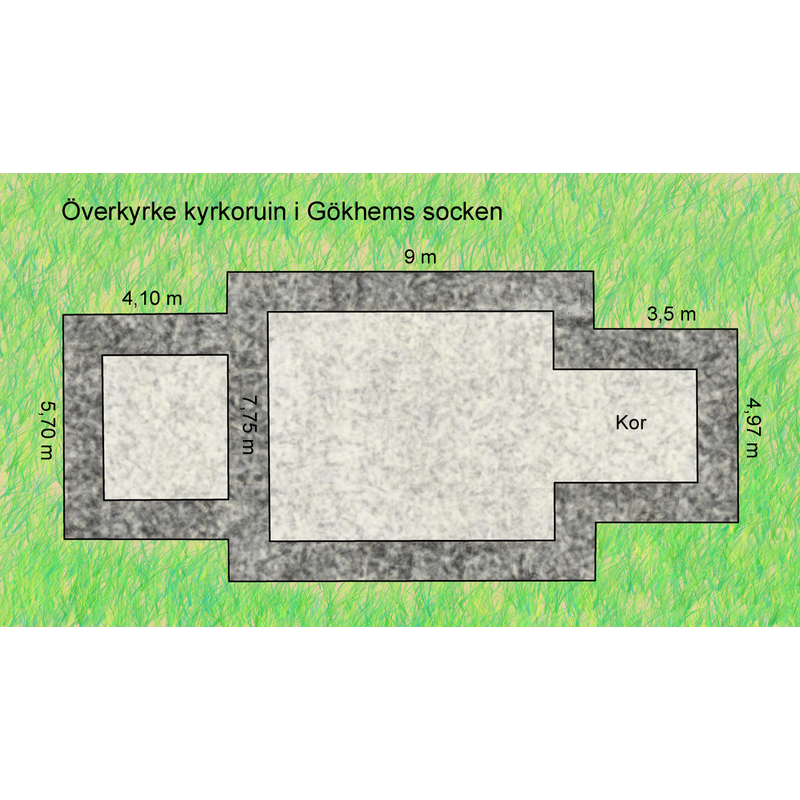
Scene Description: Source caption: "Planskiss av Överkyrke kyrkoruin i Gökhems socken, Vilske härad, Falköpings kommun, f.d. Skaraborgs län, Västergötland, Västra Götalands län, Sverige. Planskissen renritad av Gunnar Creutz 2010 efter en äldre uppmätning."
Copyright Statement: Image copyright © Gunnar Creutz, 2010
Image Source: digital photograph taken 14 December 2010 by Gunnar Creutz [
Copyright Instructions: CC-BY-SA-3.0
view of church interior - detail
![Source caption: "Överkyrke kyrkoruin i Gökhems socken, Vilske härad, Falköpings kommun, Västergötland, Sverige. Ruinen har beteckningen RAÄ-nummer Gökhem 44:1 i Fornminnesregistret. Överkyrke var en medeltida kyrka som låg endast 170 meter sydöst om Gökhems sockenkyrka." -- [NB: not known whether one of the two fonts listed for Gökhem in BSi was originally from this abandoned church]](/static-50478a99ec6f36a15d6234548c59f63da52304e5/compressed/1200607012_compressed.png)
Scene Description: Source caption: "Överkyrke kyrkoruin i Gökhems socken, Vilske härad, Falköpings kommun, Västergötland, Sverige. Ruinen har beteckningen RAÄ-nummer Gökhem 44:1 i Fornminnesregistret. Överkyrke var en medeltida kyrka som låg endast 170 meter sydöst om Gökhems sockenkyrka." -- [NB: not known whether one of the two fonts listed for Gökhem in BSi was originally from this abandoned church]
Copyright Statement: Image copyright © Achird, 2013
Image Source: digital photograph taken 25 July 2013 by Achird [https://commons.wikimedia.org/wiki/File:Överkyrke_kyrkoruin_i_Gökhems_socken_1553.jpg] [accessed 7 June 2020]
Copyright Instructions: CC-BY-SA-3.0
view of font in context
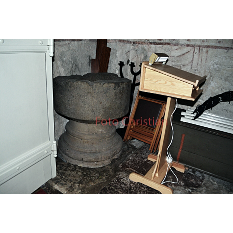
Scene Description: the second font in this church; disused to all appearances
Copyright Statement: Image copyright © Christian91, 2020
Image Source: digital photograph by Christian91 in Kyrkokartan.se [https://www.kyrkokartan.se/056590/images/56590_20125446] [accessed 6 June 2020]
Copyright Instructions: No known copyright restriction / Fair Dealing
design element - motifs - roll moulding - parallel
Copyright Statement: Image copyright © [in the public domain]
Image Source: digital image [2885-134.tif] of an undated B&W photograph in the Kulturmiljöbild, Riksantikvarieämbetet [https://commons.wikimedia.org/wiki/File:Gökhems_kyrka_-_KMB_-_16000200156582.jpg] [accessed 6 June 2020]
Copyright Instructions: PD Sweden
INFORMATION
Font ID: 22702GOK
Object Type: Baptismal Font1
Font Century and Period/Style: 13th century, Late Romanesque
Church / Chapel Name: Gökhems kyrka [Överkyrke kyrkoruin? [cf. FontNotes]]
Font Location in Church: Inside the remaining church [cf. ImagesArea]
Church Address: [NB: address and coordinates given for the Överkyrke kyrkoruin] Falköping N, 521 92 Falköping, Sweden
Site Location: Västergötland, Västra Götalands län, Sweden, Europe
Directions to Site: Located off (N) road 47, 10-12 km W of Falköping
Ecclesiastic Region: Skara stift
Historical Region: Vilske härad
Additional Comments: re-cycled font? (was this the font from the Överkyrke kyrkoruin, about 170 m. from the present parish church?)
Font Notes:
Click to view
One of two baptismal fonts in this church now. The font appears in ca. 1900 photographs already badly damaged, and is now [2020] disused in the church. It consists of a plain cylindrical basin raised on a moulded round base. No font cover present. [NB: one of the two fonts may have originated in the other medieval church at Gökhem, a farm (?) church located about 170 m. from the present parish church; it is said to have been abandoned in the mid-16th century]
COORDINATES
UTM: 33V 406508 6449026
Latitude & Longitude (Decimal): 58.172574, 13.410573
Latitude & Longitude (DMS): 58° 10′ 21.26″ N, 13° 24′ 38.06″ E
MEDIUM AND MEASUREMENTS
Material: stone, sandstone
Number of Pieces: two
Font Shape: cylindrical, mounted
Basin Interior Shape: round
Basin Exterior Shape: round
Drainage Notes: no lining