Friggeraker No. 2 / Friggeråker
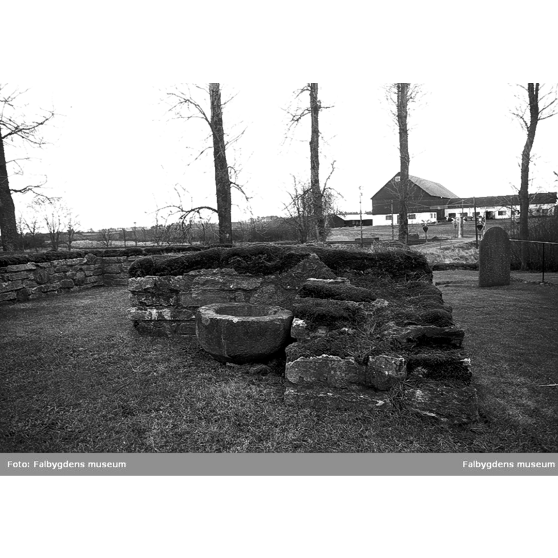
Image copyright © Falbygdens museum, 2015
CC BY-NC-ND
Results: 2 records
view of basin in context
Scene Description: Source caption: "Friggeråkers kyrka. Dopfuntens cuppa."
Copyright Statement: Image copyright © Falbygdens museum, 2015
Image Source: digital image [2M16-S-0089-4-12] of a 1989 B&W photograph in the Falbygdens museum [https://digitaltmuseum.se/021016038151/friggerakers-kyrka-dopfuntens-cuppa] [accessed 28 October 2023]
Copyright Instructions: CC BY-NC-ND
view of basin in context
![Source caption: "Friggeråkers kyrkoruin [...] Dopfuntscuppa, sandsten, medeltida, stående på ödekyrkogården."](/static-50478a99ec6f36a15d6234548c59f63da52304e5/compressed/0200603000_compressed.png)
Scene Description: Source caption: "Friggeråkers kyrkoruin [...] Dopfuntscuppa, sandsten, medeltida, stående på ödekyrkogården."
Copyright Statement: Image copyright © [in the public domain]
Image Source: digital image [9934-028.tif] of an undated B&W photograph by Hilding Svensson, in the Kulturmiljöbild, Riksantikvarieämbetet [https://commons.wikimedia.org/wiki/File:Friggeråkers_kyrkoruin_-_KMB_-_16000200155333.jpg] [accessed 3 June 2020]
Copyright Instructions: PD Sweden
INFORMATION
Font ID: 22693FRI
Object Type: Baptismal Font1, basin only?
Font Century and Period/Style: Medieval
Church / Chapel Name: Friggeråkers kyrka
Font Location in Church: [in the abandoned churchyard of the old Friggeråkers kyrka demolished in 1891]
Previous Font Location(s): Friggeråkers kyrka
Church Address: [NB: address and coordinates given for the church site] Friggeråkers Kyrkby, 521 96 Falköping, Sweden -- Tel.: +46 515 77 63 00
Site Location: Västergötland, Västra Götalands län, Sweden, Europe
Directions to Site: Located off (W) highway 46, N of the 184, 4 km NNE of Falköping and in its municipality
Ecclesiastic Region: Skara stift
Historical Region: Gudhems härad
Additional Comments: disused font? (cf. FontNotes]
Font Notes:
Click to view
A hemispheric basin on the grounds of the abandoned churchyard of the demolished church at Friggeråker is shown in an undated B&W photograph [9934-028.tif] by Hilding Svensson, in the Kulturmiljöbild, Riksantikvarieämbetet [https://commons.wikimedia.org/wiki/File:Friggeråkers_kyrkoruin_-_KMB_-_16000200155333.jpg] [accessed 3 June 2020]. The source states simply as a basin of a basin of a medieval font in the abandoned churchyard; it is very worn and appears plain now but may have been decorated originally.
COORDINATES
UTM: 33V 416483 6451567
Latitude & Longitude (Decimal): 58.197389, 13.579175
Latitude & Longitude (DMS): 58° 11′ 50.6″ N, 13° 34′ 45.03″ E
MEDIUM AND MEASUREMENTS
Material: stone, sandstone
Font Shape: hemispheric
Basin Interior Shape: round
Basin Exterior Shape: round
Drainage Notes: no lining