Penbryn No. 1 / Llanfihangel Penbryn / Llanvihangel Pen y Bryn / Llanvihangel Penbryn
Results: 1 records
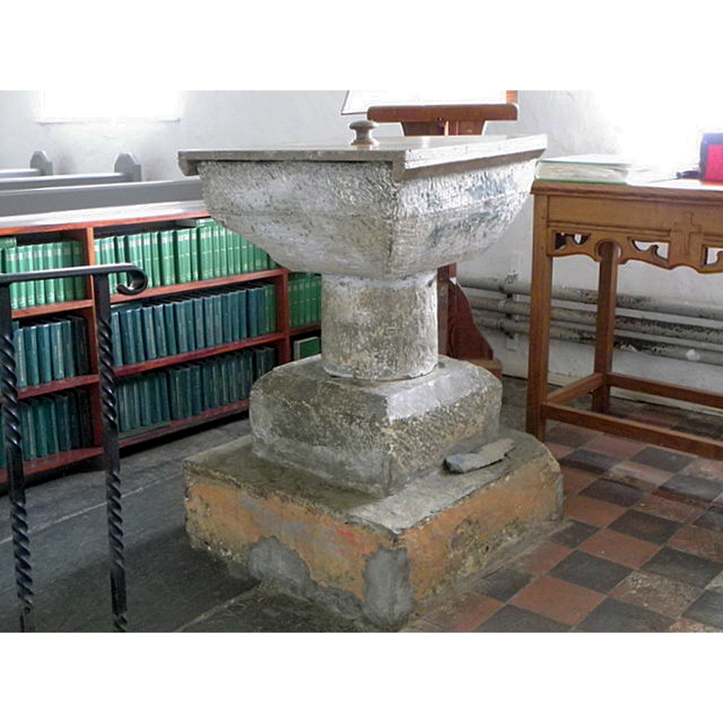
view of font and cover in context - northwest side
INFORMATION
Font ID: 22561PEN
Object Type: Baptismal Font1
Font Century and Period/Style: 12th - 13th century, Transitional
Church / Chapel Name: Parish Church of St. Michael, Penbryn
Font Location in Church: Inside the church, at the W end
Church Patron Saint(s): St. Michael
Church Address: Llandysul SA44 6QN, United Kingdom -- Tel.: +44 1545 570433
Site Location: Ceredigion, Wales, United Kingdom
Directions to Site: Located off (N) of the A487, 3-4 km NE of Aberporth, 14 km NNE of Cardigan
Ecclesiastic Region: Diocese of St Davids
Historical Region: formerly Cardiganshire
Font Notes:
Click to view
Meyrick (1808) reports: "The font is a square bason". Noted in Lewis' Dictionary edition of 1849: "the font is an ancient square basin". The entry for this church in COFLEIN [https://www.coflein.gov.uk/en/site/105363/details/st-michaels-church-penbryn] [accessed 19 January 2020] notes: "During the medieval period the church was a parish church of the deanery of Sub-Aeron, at which time it was a possession of Talley Abbey (Premonstratensian). [...] The nave is thirteenth-century in date. The chancel dates from the fourteenth century. The porch dates from the seventeenth century. The church was restored in 1887 [...] The church was renovated in 1957 [...] The square font is medieval in date. Another medieval font is in the porch. The limestone square, scalloped font dates to the twelfth century, and was originally from St Llawddog's Church, Cenarth (NPRN 309895). It was removed to St Michael's from St John's Church, Sarnau (NPRN 400366)." [cf. BSI entry for Penbryn No.2 for the porch font]. The entry for this church in British Listed Buildings [https://britishlistedbuildings.co.uk/300009899-church-of-st-michael-penbryn] [accessed 19 January 2020] notes: "Plain square tooled font with deeply chamfered underside on cylindrical shaft and square base. Possibly C13."
Noted by Tim Palmer as a 'scallop and dart' font made of Dundry stone [source: e-mail communication of 17 March 2010 to BSI]. Palmer notes two other Ceredigion 'scallop and dart' fonts, those at Llanfihangel Ystrad and Tremain, although the font at Llanfihangel Ystrad has had the 'dart' motif chiselled off.
Noted by Tim Palmer as a 'scallop and dart' font made of Dundry stone [source: e-mail communication of 17 March 2010 to BSI]. Palmer notes two other Ceredigion 'scallop and dart' fonts, those at Llanfihangel Ystrad and Tremain, although the font at Llanfihangel Ystrad has had the 'dart' motif chiselled off.
COORDINATES
UTM: 30U 397833 5778124
Latitude & Longitude (Decimal): 52.144167, -4.493056
Latitude & Longitude (DMS): 52° 8′ 39″ N
MEDIUM AND MEASUREMENTS
Material: stone
Font Shape: square, mounted
Basin Interior Shape: round
Basin Exterior Shape: square
LID INFORMATION
Date: modern
Material: wood
Apparatus: no
Notes: plain and flat, with knob handle; modern
REFERENCES
- Lewis, Samuel, A Topographical Dictionary of England, Comprising the Several Counties, Cities, Boroughs, Corporate and Market Towns, Parishes, Chapelries, and Townships, and the Islands of Guernsy, Jersey, and Man, with Historical and Statistical Descriptions [...], London: S. Lewis, 1848-1849
- Meyrick, Samuel Rush, The History and Antiquities of the County of Cardigan [...], London: Longman, Hurst, Rees, and Orme, 1808, p. 181