Brignall / Brigenhale / Brigenhall / Bringhal / Bringhale / Bringhenale [Domesday]
![Main image for Brignall / Brigenhale / Brigenhall / Bringhal / Bringhale / Bringhenale [Domesday]](/static-50478a99ec6f36a15d6234548c59f63da52304e5/compressed/0200204001_compressed.png)
Image copyright © [in the public domain]
PD
Results: 7 records
view of font
Scene Description: the old font, "much cut down and reworked" [VCH cf. FontNotes]]
Copyright Statement: Image copyright © [in the public domain]
Image Source: digital image of an illustration in Whitaker (1823)
Copyright Instructions: PD
view of church exterior in context - west view
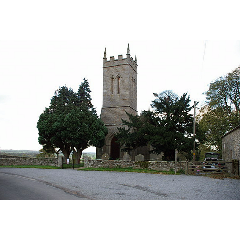
Scene Description: the 1834 church
Copyright Statement: Image copyright © Alexander P Kapp, 2007
Image Source: digital photograph taken 26 October 2006 by Alexander P Knapp [www.geograph.org.uk/photo/340192] [accessed 8 November 2019]
Copyright Instructions: CC-BY-SA-3.0
view of church exterior - southeast view
![Source caption: "The church was built in 1834 [...] Stone from the old church was used in the construction of the new building."](/static-50478a99ec6f36a15d6234548c59f63da52304e5/compressed/1191108003_compressed.png)
Scene Description: Source caption: "The church was built in 1834 [...] Stone from the old church was used in the construction of the new building."
Copyright Statement: Image copyright © Paul Buckingham, 2013
Image Source: digital photograph taken 3 September 2013 by Paul Buckingham [www.geograph.org.uk/photo/3641265] [accessed 8 November 2019]
Copyright Instructions: CC-BY-SA-2.0
view of church interior - looking east
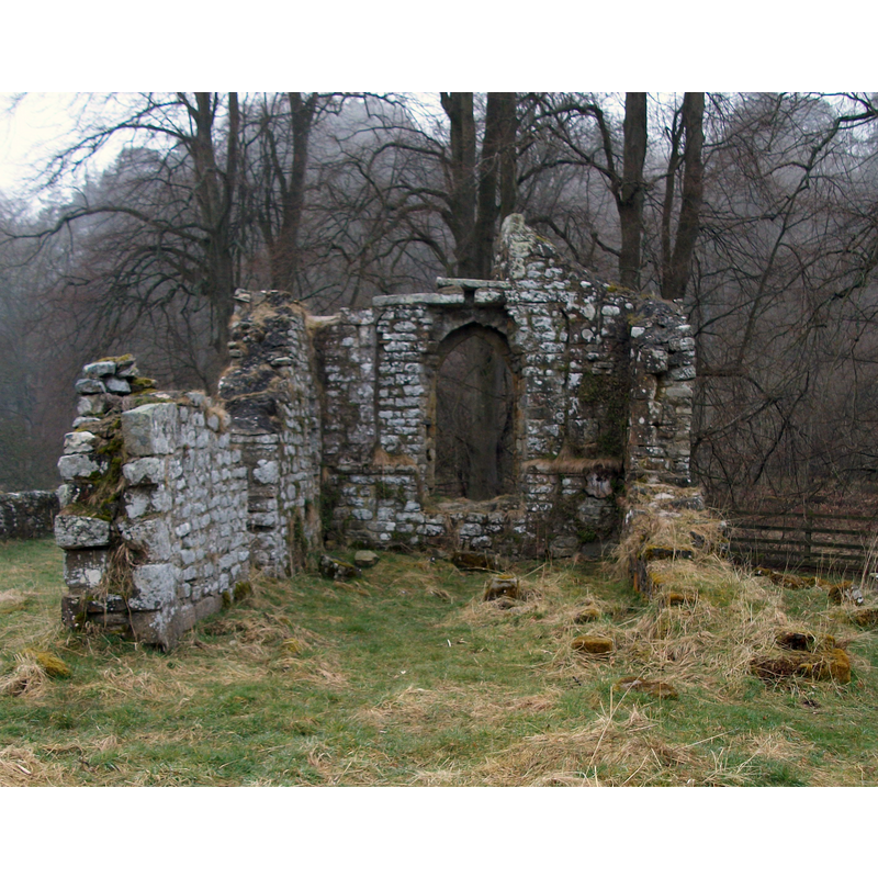
Scene Description: Source caption: "Old Church Of ST MARY. Church probably built in 13th century, remodelled in 18th century and largely demolished 1833. The ruins of the east gable and side walls of the chancel remain. Built of rubble with dressed stone. A fragment of 9th century cross shaft is built in to the interior north wall of the ruined church."
Copyright Statement: Image copyright © Matthew Hatton, 2013
Image Source: digital photograph taken 12 April 2013 by Matthew Hatton [www.geograph.org.uk/photo/3408509] [accessed 8 November 2019]
Copyright Instructions: CC-BY-SA-2.0
view of church exterior in context
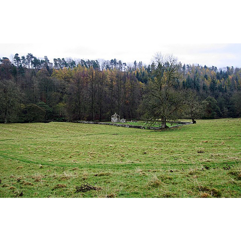
Scene Description: Source caption: "Old St. Mary's, Brignall, by the Greta. From the village of Brignall, a footpath wends its way down to the site of the original St. Mary's church, right by the banks of the River Greta where another footpath follows the left bank (from Brignall Mill to Greta Bridge). Although the church occupies a substantial walled area, there are no other readily visible remains of the Medieval village of Brignall."
Copyright Statement: Image copyright © Andy Waddington, 2009
Image Source: digital photograph taken 10 November 2009 by Andy Waddington [www.geograph.org.uk/photo/1575790] [accessed 8 November 2019]
Copyright Instructions: CC-BY-SA-2.0
design element - patterns - diaper
Scene Description: the old font, "much cut down and reworked" [VCH cf. FontNotes]]
Copyright Statement: Image copyright © [in the public domain]
Image Source: digital image of an illustration in Whitaker (1823)
Copyright Instructions: PD
design element - architectural - column - 6
Scene Description: the old font, "much cut down and reworked" [VCH cf. FontNotes]]
Copyright Statement: Image copyright © [in the public domain]
Image Source: digital image of an illustration in Whitaker (1823)
Copyright Instructions: PD
INFORMATION
Font ID: 22437BRI
Object Type: Baptismal Font1
Font Century and Period/Style: 13th century [altered], Early English [altered]
Church / Chapel Name: Parish Church of St. Mary the Virgin [originally from Old St Mary's]
Font Location in Church: Inside the new church
Church Patron Saint(s): St. Mary the Virgin
Church Address: [NB: address & coordinates for the old church in ruins] Brignall, Barnard Castle DL12 9SF, UK
Site Location: Durham, North East, England, United Kingdom
Directions to Site: Located off (W) the A66, on the N bank of the Greta river, SE of Barnard Castle
Historical Region: Hundred of Land of Count Alan -- formerly York North Riding
Additional Comments: re-used font (originally from the medieval church; moved to the new church) -- disappeared font? (the one from the original 12thC church here)
Font Notes:
Click to view
There is a multiple-place [28 places] entry for Brignall [variant spellings] in the Domesday survey [https://opendomesday.org/place/NZ0712/brignall/] [accessed 8 November 2019]; it mentions two churches in it. Whitaker (1823) comments on the modernisation of the church here having "destroyed almost every vestige of antiquity", and provides an illustration of its font. The entry for this parish in the Victoria County History (York North Riding, vol. 1, 2014) notes; "Roger de Mowbray gave the church in the 12th century to the Hospital of SS. Peter and Leonard of York [...] The ruins of the old church of ST. MARY, on the bank of the River Greta, are sufficiently preserved to show that it had an aisleless nave and chancel, the latter being of the 13th century [...] The font was removed from the old church and is of the 13th century, but, unfortunately, much cut down and reworked; it has a round bowl on a stem with six attached shafts and bases, but no capitals. Between the shafts are lines of dog-tooth ornament, mostly left unworked. [...] The church of ST. MARY THE VIRGIN, built in 1833, consecrated 4 September 1834 and restored in 1892". The ruins of Old St Mary's are listed [Listing NGR: NZ0772412196]: "Former parish church. Probably C13, remodelled in C18; largely demolished 1833 when new church (q.v.) was built. [...] In poor condition and deteriorating at time of survey."
COORDINATES
UTM: 30U 572341 6040296
Latitude & Longitude (Decimal): 54.5051, -1.8828
Latitude & Longitude (DMS): 54° 30′ 18.36″ N, 1° 52′ 58.08″ W
REFERENCES
- Victoria County History [online], University of London, 1993-. URL: https://www.british-history.ac.uk.
- Whitaker, Thomas Dunham, An history of Richmondshire, in the North Riding of the County of York [...], with illustrations by J.M.W. Turner, London: [s.n.], 1823, vol. 1: 195-196