York No. 51, Savioursgate / Eboracum / Eburacum / Eburākon / Eoforwic / Everwic / Jórvík
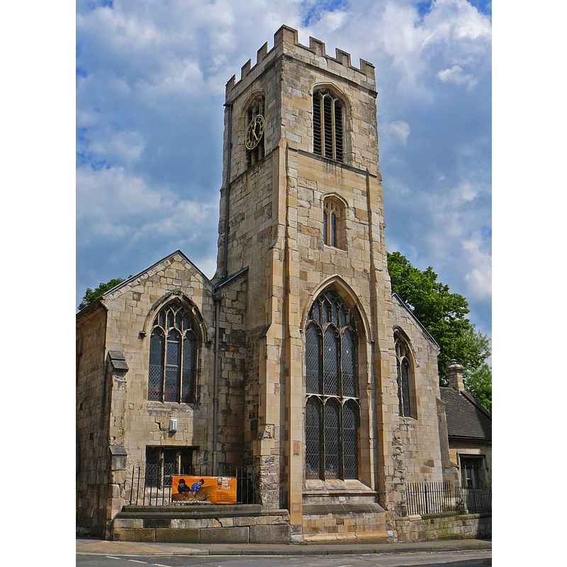
Image copyright © Tim Green, 2008
CC-BY-SA-2.0
Results: 1 records
view of church exterior - west end
Scene Description: redundant since 1954; used now [June 2008] by the York Archaeological Trust as Archaeological Resource Centre
Copyright Statement: Image copyright © Tim Green, 2008
Image Source: digital photograph taken 5 June 2008 by Tim Green [www.flickr.com/photos/93416311@N00/2573899792] [accessed 30 August 2019]
Copyright Instructions: CC-BY-SA-2.0
INFORMATION
Font ID: 22307YOR
Object Type: Baptismal Font1?
Font Century and Period/Style: 11th century (late?), Norman
Church / Chapel Name: Parish Church of St. Saviour, Savioursgate [aka St Saviour in the Marsh / ecclesia sancti salvatoris in Marisco] [edundant 1954]
Font Location in Church: [cf. FontNotes]
Church Patron Saint(s): Jesus Christ
Church Notes: church documented 1088-1093 [cf. FontNotes]; re-built mid-19thC; redundant since 1954; leased to the corporation 1955; later used by the York Archaeological Trust
Church Address: St.Saviourgate, York YO1 8NN, England
Site Location: North Yorkshire, Yorkshire and the Humber, England, United Kingdom
Directions to Site: Located off (S) St Saviourgate, a block N of Hungate, in the medieval city centre
Ecclesiastic Region: [Diocese of York]
Historical Region: Hundred of York
Additional Comments: moved font? (one font moved to Holy Trinity Micklegate, York [cf. FontNotes]) -- disappeared font? (the one from the 11thC church here [cf. FontNotes])
Font Notes:
Click to view
There are twelve entries for York in the Domesday survey [https://opendomesday.org/place/SE6052/york/] [accessed 8 August 2019] eight of which mentions a church in it [cf. infra]. The entry for this parish in the Victoria County History (York, 1961) notes: "The church of ST. SAVIOUR, St. Saviourgate, is first mentioned in William II's confirmation of his father's gift of the church to St. Mary's Abbey, dated between 1088 and 1093: like the remainder of St. Mary's property it does not appear in Domesday Book. [...] St. John's, Hungate, and St. Andrew's, St. Andrewgate, were united with St. Saviour's in 1586, instead of with All Saints', Peaseholme, as had been planned in 1548. [...] The benefice and parish of St. Saviour's were united with All Saints', Pavement, in 1954. [...] In 1955 the church was leased at a nominal rent to the corporation for use as a store for the Castle Museum. [...] There were at least eight chantries in the church— probably the largest number of any city parish church. [...] this building, with the exception of part of the tower, was taken down in in 1844 and re-erected with new stone in Perpendicular Style. There is some 15th-century stained glass in the east window. When the church was leased to the corporation in 1955, the church furniture, which included a communion table and sanctuary chairs of the early 17th century, was placed in the chancel. [...] The parish comprised the area around the church: St. John's, Hungate, and St. Andrew's, St. Andrewgate, were annexed to this in 1586. Parts of the area north-east of the city between St. Olave's and Osbaldwick also lay in St. Saviour's." The entry for this church in An iventory of of Historical Monuments (York, vol. 5, 1981) notes: "St. Saviour in the Marsh, 'ecclesia sancti salvatoris in Marisco' (Drake, 310), was built on swampy ground reclaimed from the marsh. Oak coffins found 14 ft. below the floor, including one beneath the S.W. buttress, were probably pre-Conquest (YG, 8 May 1845; 18 April 1846) [...] It was completely rebuilt in the 15th century [...] It was leased to York Corporation in 1955 and the fittings were dispersed. [...] Font and Font-cover, removed to Holy Trinity, Micklegate (York III, 15a)." The entry for this church in Historic England [Listing NGR: SE6059051890] notes: "Formerly known as: Church of St Saviour-in-the-Marshes ST SAVIOURGATE. Parish church, now educational resource centre; attached railings and gates forming northern and western boundaries of former churchyard. C15 arcades and west end; north and south aisles rebuilt 1844-45; vestry of 1878. Church made redundant in 1954 and converted to present use in 1991"; no font mentioned.
COORDINATES
UTM: 30U 626097 5980732
Latitude & Longitude (Decimal): 53.959557, -1.078059
Latitude & Longitude (DMS): 53° 57′ 34.4″ N, 1° 4′ 41.01″ W
REFERENCES
- Victoria County History [online], University of London, 1993-. URL: https://www.british-history.ac.uk.