York No. 38, Pavement / Eboracum / Eburacum / Eburākon / Eoforwic / Everwic / Jórvík
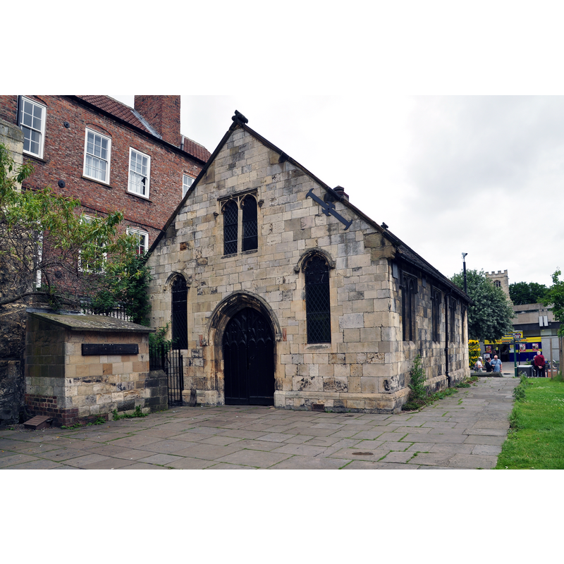
Image copyright © Nilfanion, 2014
CC-BY-SA-4.0
Results: 3 records
view of church exterior in context
Scene Description: "Parish room, incorporating minimal remains of the parish church of St Crux. 1888 re-using early C15 masonry" [source: Historic England [Listing NGR: SE6049751832]]
Copyright Statement: Image copyright © Nilfanion, 2014
Image Source: digital photograph taken 15 June 2014 by Nilfanion [https://en.wikipedia.org/wiki/File:Parish_Room_of_St_Crux,_York_(8469).jpg] [accessed 9 August 2019]
Copyright Instructions: CC-BY-SA-4.0
view of church exterior - southeast view
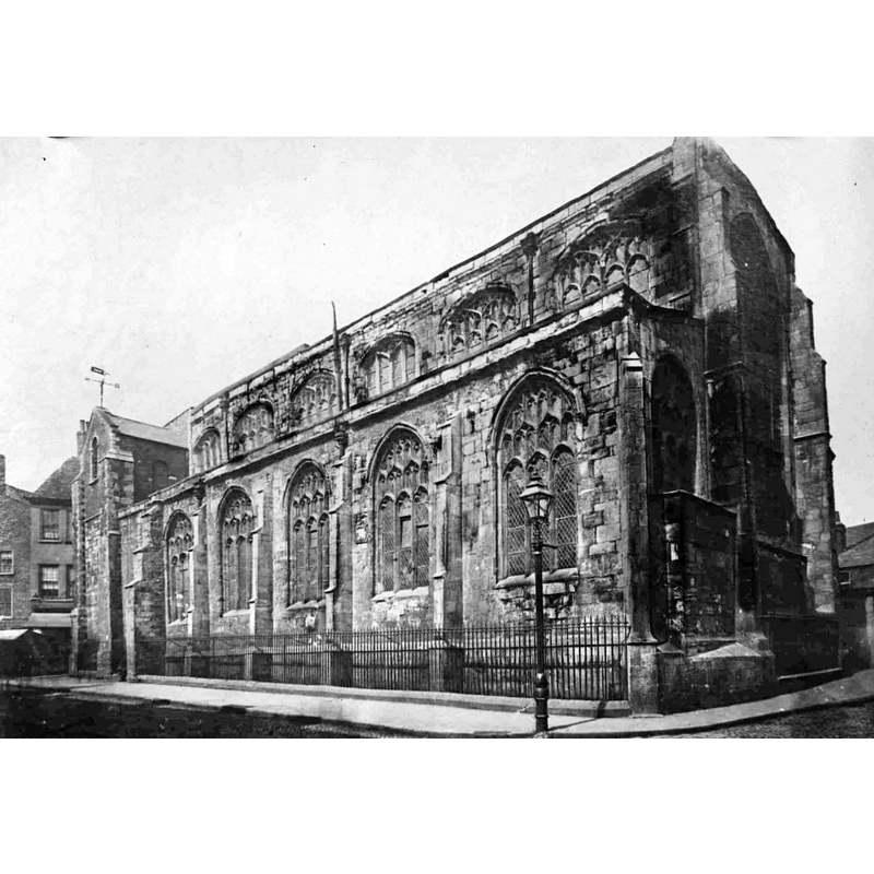
Scene Description: the demolition St Crux took place between 1884 and 1887
Copyright Statement: Image copyright © YAYAS [Yorkshire Architectural and York Archaeological Society], 2019
Image Source: digital image of a B&W photograph in YAYAS [www.yorkpress.co.uk/news/15486402.gallery-lost-church-of-st-crux-and-other-old-photos/#gallery0] [accessed 9 August 2019]
Copyright Instructions: No known copyright restriction / Fair Dealing
view of church exterior in context
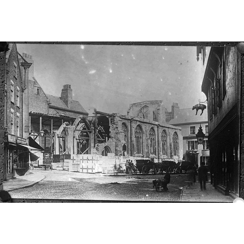
Scene Description: the demolition St Crux took place between 1884 and 1887
Copyright Statement: Image copyright © YAYAS [Yorkshire Architectural and York Archaeological Society], 2019
Image Source: digital image of a B&W photograph in YAYAS [www.yorkpress.co.uk/news/15486402.gallery-lost-church-of-st-crux-and-other-old-photos/#gallery0] [accessed 9 August 2019]
Copyright Instructions: No known copyright restriction / Fair Dealing
INFORMATION
Font ID: 22283YOR
Object Type: Baptismal Font1?
Font Century and Period/Style: 11th century, Pre-Conquest? / Norman
Church / Chapel Name: Parish Church of St. Crux, Pavement [demolished]
Font Location in Church: [disappeared]
Church Patron Saint(s): The Holy Cross
Church Address: coordinates and address are for St Crux Parish Room: Whip-Ma-Whop-Ma-Gate, York YO1 8BL, UK
Site Location: North Yorkshire, Yorkshire and the Humber, England, United Kingdom
Directions to Site: Located about 100 yds N of the Foss river, E of the Ouse and the JORVIK Viking Centre, in the historical city centre
Ecclesiastic Region: [Diocese of York]
Historical Region: Hundred of York
Additional Comments: disappeared font? (the one from the Domesday-time church here)
Font Notes:
Click to view
There are twelve entries for York in the Domesday survey [https://opendomesday.org/place/SE6052/york/] [accessed 8 August 2019] eight of which mentions a church in it [cf. infra]. The entry for York churches in the Victoria County History (York, 1961) notes: "Eight churches are mentioned in Domesday: [...] three (St. Crux, St. Cuthbert, and Holy Trinity, Micklegate) may be certainly identified, and four (All Saints, Pavement, St. Andrew, St. Andrewgate, St. Martin, Coney Street, and St. Mary, Castlegate) with considerable probability; one is not named [...] Only of one church, and that an early one, is the foundation date certainly known: St. Olave's. [...] In 1087 the church of ST. CRUX, Pavement, was held by the Count of Mortain [...] The church which survived into the 19th century [...] was probably built early in the fifteenth. [...] The church was untouched by the 16th-century reorganization; it was united with All Saints', Pavement, in 1885, [...] and the fabric demolished in 1887. [...] By the 1880's the structure needed complete restoration: it was partially taken down in 1884 but the rebuilding was never begun and the ruin remained until, in 1887, it was cleared away. Out of the materials was built a parish room which occupies part of the site of the church." That Parish Room is noted in An Inventory of the Historical Monuments in City of York (vol. 5, Central, London: HMSO, 1981) [www.british-history.ac.uk/rchme/york/vol5/pp11-12] [accessed 9 August 2019]: "St. Crux Parish Room stands on the N.W. side of Pavement at the corner of Whip-ma-whop-magate; it is on the site and incorporates slight remains of the former Parish Church of St. Crux [...] The parish room was built on part of the site in 1888, using materials from the demolished church and incorporating a section of the old N. wall; many monuments and other fittings were reset inside. [...] Font: octagonal bowl on octagonal shaft with moulded cap and base, 15th-century; now at St. Andrew's, Bishopthorpe." The entry for the St Crux Parish Hall in Historic England [Listing NGR: SE6049751832] notes: "Parish room, incorporating minimal remains of the parish church of St Crux. 1888 re-using early C15 masonry" but mentions no font. [cf. BSI entry for Bishopthorpe for the church that received the 15thC font from St. Crux].
COORDINATES
UTM: 30U 625998 5980671
Latitude & Longitude (Decimal): 53.95903, -1.07959
Latitude & Longitude (DMS): 53° 57′ 32.51″ N, 1° 4′ 46.52″ W
REFERENCES
- Victoria County History [online], University of London, 1993-. URL: https://www.british-history.ac.uk.