Heutregiville / Heudrésiville / Heutrégiville / Hildrizei Villa / Huldriciaca Villa
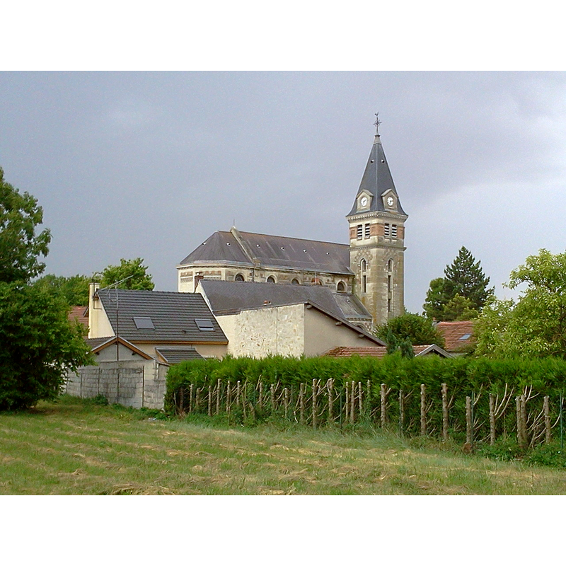
Image copyright © Gwendo51, 2013
CC-BY-SA-3.0
Results: 5 records
view of church exterior in context - northeast view
Scene Description: Source caption: " Vue de l'église Sainte Marie-Madeleine d'Heutrégiville depuis le cimetière." [NB: the present church of 1926]
Copyright Statement: Image copyright © Gwendo51, 2013
Image Source: digital photograph 22 July 2013 by Gwendo51 [https://commons.wikimedia.org/wiki/File:Église_Sainte_Marie-Madeleine_d'Heutrégiville.jpg] [accessed 6 August 2022]
Copyright Instructions: CC-BY-SA-3.0
view of church exterior - southwest view
![Source caption: " vue de l'aancienne [sic] église d' Heutrégiville dans l'almanach Matot-Braine de 1910." [NB: the church was blown up in 1918]](/static-50478a99ec6f36a15d6234548c59f63da52304e5/compressed/1220806005_compressed.png)
Scene Description: Source caption: " vue de l'aancienne [sic] église d' Heutrégiville dans l'almanach Matot-Braine de 1910." [NB: the church was blown up in 1918]
Copyright Statement: Image copyright © G. Garitan, 2015
Image Source: digital image 2015 by G. Garitan of an illustration in Matot-Braine (1910) [https://commons.wikimedia.org/wiki/File:Portail_église_Heutregiville.JPG] [accessed 6 August 2022]
Copyright Instructions: CC-BY-SA-4.0
human figure - head - 4

Scene Description: some wear headgear; some do not

animal - mammal - lion - head - inverted - vegetation stemming from mouth
design element - motifs - foliage - palmette
INFORMATION
Font ID: 22279HEU
Object Type: Baptismal Font1
Font Century and Period/Style: 12th - 13th century, Romanesque
Church / Chapel Name: Église paroissiale Sainte-Marie-Madeleine d'Heutrégiville
Font Location in Church: Inside the church
Church Patron Saint(s): St. Mary Magdalene
Church Notes: present church of 1926 replaced an earlier one of ca. 1350 blown up in 1918 on the same site; an earlier church of the 11th or 12thC may have existed here originally
Church Address: Rle Baudit, 51110 Heutrégiville, France
Site Location: Marne, Grand Est, France, Europe
Directions to Site: Located off the D20-D33 crossroads, 16 km NE of Bourgogne, about 20 km NE of Reims, 45 km NW of Châlons-en-Champagne
Ecclesiastic Region: Diocèse de Reims
Historical Region: Champagne-Ardenne
Font Notes:
Click to view
Noted in La Grande encyclopédie. Inventaire raisonné des sciences, des lettres et des arts, volume 20 (Lamirault et cie, 1886): p. 54. Baptismal font noted in Adolphe Laurent Joanne's Géographie du département de la Marne avec une carte coloriée et 9 gravures (Paris: Hachette, 1909). Baptismal font noted in Adolphe Laurent Joanne's Géographie du département de la Marne avec une carte coloriée et 9 gravures (Paris: Hachette, 1909). The PLU DE HEUTREGIVILLE /// RAPPORT DE PRESENTATION [https://www.grandreims.fr/fileadmin/grandreims/MEDIA/Les_competences/Urbanisme/Heutregiville/Heutregiville_PLUapprouve_26-09-2019/A-RP-PLUHeutregiville.pdf] [accessed 6August 2022] notes: "Les fonds [sic] baptismaux les plus anciens de la Marne (à priori du XIème s.) ont été retrouvés au sein de cette dernière, qui fut dynamitée en 1918 mais reconstruite en 1926." Listed in Palissy [ref.: PM51000485]: "Fonts baptismaux [...] Pierre de Givet. Ornementation composée de figures [...] 11e siècle ; 12e siècle (?) [...] Anciennement décrits comme étant en marbre sculpté". The entry for this church in the Travaux de l'Académie nationale de Reims, Volume 146,1931-1932, p. 33 describes the font as being made of "pierre de Tournai" decorated with "quatre nascarons", tendrils and bunches of grapes; the base is described as a central shaft with four outer colonnettes; it is dated to the first half of the 12th century; the measurements given are 83 cm for the height and 260 cm for the circumpherence; the source refers to the drawing in the Matot almanach of 1916 (p. 303) and a good photograph in the Archives des Monuments historiques; it further mentions the object was damaged. Noted and illustrated in https://jeanluccollignon.blog4ever.com/des-baptisteres-marnais-importes-de-belgique [accessed 6 August 2022]; the basin remains more or less intact but the present pedestal base is a modern replacement. A modern wooden cover is in place [NB: this site has disable the downloading/copying of images and text].
COORDINATES
UTM: 31U 591860 5464499
Latitude & Longitude (Decimal): 49.3263, 4.2642
Latitude & Longitude (DMS): 49° 19′ 34.68″ N, 4° 15′ 51.12″ E
MEDIUM AND MEASUREMENTS
Material: stone, limestone (blue) (Givet)
Font Shape: round, mounted
Basin Interior Shape: round
Basin Exterior Shape: round
Font Height (less Plinth): 83 cm*
Notes on Measurements: * [cf. FontNotes] 260 cm of circumference
LID INFORMATION
Date: modern
Material: wood
Apparatus: no
Notes: round, plat and plain