Cannock / Canoc / Canot / Chenet / Chnoc / Cnot
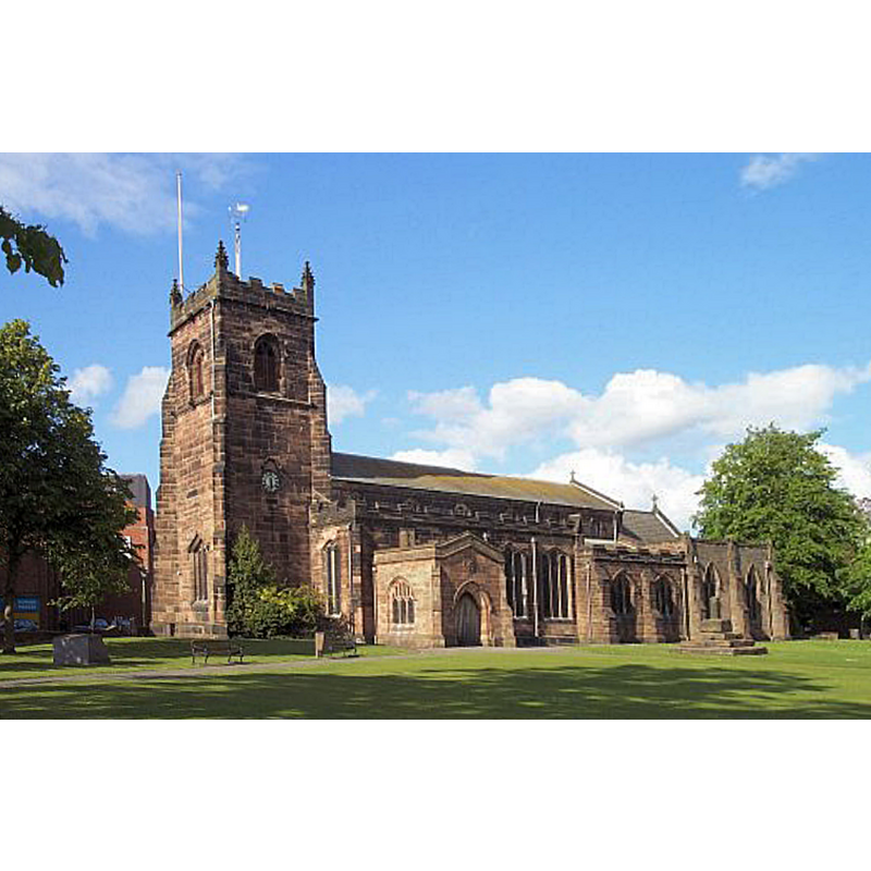
Image copyright © Geoff Pick, 2006
CC-BY-SA-2.0
Results: 2 records
view of church exterior - southwest view
Copyright Statement: Image copyright © Geoff Pick, 2006
Image Source: edited detail of a digital photograph taken 3 August 2002 by Geoff Pick [www.geograph.org.uk/photo/119236] [accessed 24 July 2019]
Copyright Instructions: CC-BY-SA-2.0
symbol - shield - blank
![on the sides of the now disappeared 15thC basin of the present font; the present basin is a modern replacement [cf. FontNotes]](/static-50478a99ec6f36a15d6234548c59f63da52304e5/others/image_not_available.jpg)
Scene Description: on the sides of the now disappeared 15thC basin of the present font; the present basin is a modern replacement [cf. FontNotes]
![on the sides of the now disappeared 15thC basin of the present font; the present basin is a modern replacement [cf. FontNotes]](/static-50478a99ec6f36a15d6234548c59f63da52304e5/bsi-testing-site/others/image_not_available.jpg)
INFORMATION
Font ID: 22256CAN
Object Type: Baptismal Font1
Font Century and Period/Style: 15th century [base only?] [composite font], Late Medieval
Workshop/Group/Artisan: heraldic font [on the disappeared 15thC basin]
Church / Chapel Name: Parish Church of St. Luke and St. Thomas Huntington
Font Location in Church: [cf. FontNotes]
Church Patron Saint(s): St. Luke and St. Thomas
Church Address: Church St, Cannock WS11 1DE, UK -- Tel.: +44 1543 502131
Site Location: Staffordshire, West Midlands, England, United Kingdom
Directions to Site: Located off (NE) the A34-A4601 crossroads, 15-16 km NE of Wolverhampton,
Ecclesiastic Region: Diocese of Lichfield
Historical Region: Hundred of [East] Cuttlestone
Additional Comments: altered font (present font has 15thC base but modern replacement basin) -- disappeared font? (the one from the 12thC church here)
Font Notes:
Click to view
There are two entries for Cannock [variant spelling] in the Domesday survey [https://opendomesday.org/place/SJ9810/cannock/] [accessed 24 July 2019] neither of which mentions cleric or church in it. The entry for this parish in the Victoria County History (Stafford, vol. 5, 1959) notes: "There was a chapel at Cannock by the 12th century. [...] It was probably founded as a dependency of Penkridge collegiate church [...] It is not known when the chapel acquired the status of a parish church. In 1293 the Bishop of Coventry and Lichfield insisted that it was a church and not a chapel [...] The church of ST. LUKE consists of an aisled and clerestoried nave of six bays, chancel, north vestry, south chapel, and west tower. The nave dates largely from the 14th and the tower from the 16th century. The south nave wall was rebuilt in 1752–3. Between 1878 and 1882 the nave was extended eastwards, and the present chancel and vestry were built. The south chapel was added in 1949. The earliest masonry in the building, which occurs near the west end of the north aisle, dates from the late 12th or early 13th century. This suggests that the 13th-century church was aisled and of its present width. An almost complete rebuilding took place in the 14th century [...] The church formerly contained an octagonal font, probably of the 15th century, with a moulded bowl having flat shields on four of its faces. [...] The present bowl, restored and mounted on a new pedestal in memory of Jack Ball (d. 1944), [...] is similar but the shields are missing. The font's position has been moved at least twice." [NB: the interior plan of this church in the VCH entry [cf. supra] shows the font in the northwest corner of the north aisle].
COORDINATES
UTM: 30U 565989 5838477
Latitude & Longitude (Decimal): 52.692183, -2.023631
Latitude & Longitude (DMS): 52° 41′ 31.86″ N, 2° 1′ 25.07″ W
REFERENCES
- Victoria County History [online], University of London, 1993-. URL: https://www.british-history.ac.uk.