Lichfield No. 4 / Chad-Stowe / Lecefelle / Lichfield St Chad / Stow St. Chad / Stowe
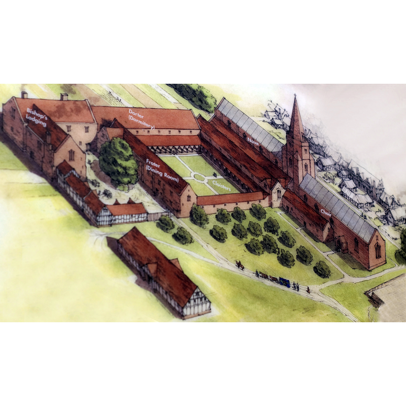
Image copyright © Lichfield District Council, 2019
CC-BY-SA-3.0
Results: 2 records
view of church exterior in context - southeast view
Scene Description: Source caption: "An artist's impression of what the Friary Site would have looked like before dissolution."
Copyright Statement: Image copyright © Lichfield District Council, 2019
Image Source: digital image of an undated illustration by (in?) Lichfield District Council [https://commons.wikimedia.org/wiki/File:Friary_Diagram.jpg] [accessed 15 July 2019]
Copyright Instructions: CC-BY-SA-3.0
view of context
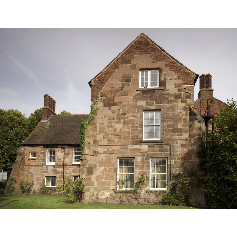
Scene Description: Source caption: "The only remaining buildings of the original Friary. These early 16th century buildings made up the Bishops Lodgings. They now form part of Lichfield Library"
Copyright Statement: Image copyright © Bs0u10e01, 2010
Image Source: digital photograph taken 30 September 2010 by Bs0u10e01 [https://commons.wikimedia.org/wiki/File:Friary_Bishops_Lodgings.jpg] [accessed 15 July 2019]
Copyright Instructions: CC-BY-SA-3.0
INFORMATION
Font ID: 22242LIC
Object Type: Baptismal Font1?
Font Century and Period/Style: 13th century (mid?), Early English
Church / Chapel Name: Franciscan Friary Church [disappeared]
Font Location in Church: [disappeared]
Church Address: The Friary, Lichfield WS13 6QX, UK
Site Location: Staffordshire, West Midlands, England, United Kingdom
Directions to Site: The site of the disappeared church is in the large rectangle near the corner of The Friary and St John St, just NW of it, in the W area of Lichfield
Ecclesiastic Region: [Diocese of Lichfield]
Historical Region: Hundred of Offlow
Additional Comments: disappeared font? (the one from 13thC the friary church here)
Font Notes:
Click to view
There is an entry for this Lichfield [variant spelling] in the Domesday survey [https://opendomesday.org/place/SK1109/lichfield/] [accessed 15 July 2019]; it reports five priests, but not a church in it, though there must have been one there. The entry for this friary in the Victoria County History [Stafford, vol. 3, 1970) notes: "From the autumn of 1237 come the first signs that the Grey Friars were beginning the 'construction of their dwellings and chapel' at Lichfield [...] The friary stood in the south-west part of the city on the west side of Bird Street and St. John Street. The site is crossed by Friary Road, built in the 1920s, [...] but the portion formerly occupied by the church and some of the conventual buildings is preserved as an open space. [...] The church was large: the nave was of five bays and measured 110 × 60 feet, while the chancel was 95 × 28 feet. The tower was probably at the crossing. The cloister, 80 feet square, lay on the south side of the church, and Friary Road follows the line of its south wall. The Bishop's Lodging on the southern part of the site was enlarged by Gregory Stonyng, in 1545 and is now incorporated in the Friary School."
COORDINATES
UTM: 30U 579088 5837529
Latitude & Longitude (Decimal): 52.68191, -1.83008
Latitude & Longitude (DMS): 52° 40′ 54.88″ N, 1° 49′ 48.29″ W
REFERENCES
- Victoria County History [online], University of London, 1993-. URL: https://www.british-history.ac.uk.