Kilburn Priory / Cuneburna / Keleburne
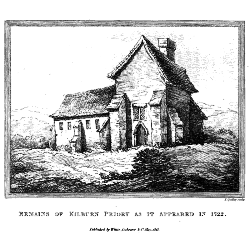
Image copyright © [in the public domain]
CC-PD-/Mark / PD-Art (PD-old-100)
Results: 1 records
view of context
Scene Description: artist's rendering of the remains of Kilburn Priory in 1722 -- by that time none of the original buildings remained standing, having been demolished after the 1546 take over by the Earl of Warwick
Copyright Statement: Image copyright © [in the public domain]
Image Source: digital image of a 1722 engraving by I Quilley in John J. Park's "The topography and natural history of Hampstead, in the County of Middlesex" (1814: 202) [https://commons.wikimedia.org/wiki/File:Remains_of_Kilburn_Priory_as_it_appeared_in_1722.jpg] [accessed 24 May 2019]
Copyright Instructions: CC-PD-/Mark / PD-Art (PD-old-100)
INFORMATION
Font ID: 22172KIL
Object Type: Baptismal Font1?
Font Century and Period/Style: 12th century (mid?), Late Norman
Church / Chapel Name: Priory Church of St. John the Baptist
Font Location in Church: [disappeared]
Church Patron Saint(s): St. John the Baptist
Church Address: [cf. Directions (Geo)]
Site Location: Greater London, South East, England, United Kingdom
Directions to Site: The site of the medieval priory was around the area of modern Kilburn High Rd, probably off the B507 [aka Abbey Rd] at Priory Rd
Ecclesiastic Region: [Diocese of London]
Font Notes:
Click to view
No individual entry for this Kilburn found in the Domesday survey. The Victoria County History (Middlezex, vol. 1, 1969) notes: "The priory of Kilburn was situated in the parish of Hampstead, between Edgware Road and the Kilburn stream at the top of what is now Belsize Road and close to Kilburn Station (B.R.). [...] The priory was a small house of Augustinian canonesses, or possibly Benedictine nuns, [...] dedicated to St. John the Baptist and dependent on the abbey of St. Peter at Westminster [...] The nunnery was probably founded c. 1130, although a foundation may have been contemplated some years earlier by Gilbert Crispin, Abbot of Westminster, for whose soul the nuns were obliged to pray. [...] In 1306 the nuns had a grant of rents in Kilburn to maintain the fabric of their church. [...] In May 1535 the priory comprised the church, the hall, the chamber next the church, the middle chamber, the prioress's chamber, the buttery, pantry, and cellar, the inner chamber to the prioress's chamber, the chamber between the prioress's chamber and the hall, the kitchen, larder, brewhouse, and bakehouse, four rooms for the chaplain, confessor and hinds. [...] The chamber next the church was evidently the nuns' sitting-room, containing hangings, cushions, a little table, and two books of Legenda Aurea, one printed and the other manuscript, both in English. [...] The most valuable properties, however, were in the church—curtains, cloths, hangings, candlesticks, and silver vessels. [...] Being valued at less than £200 the priory was dissolved with the smaller houses [...] The site of the priory was first acquired by the Knights of St. John, by an exchange with the Crown, and afterwards in 1546 by the Earl of Warwick."
COORDINATES
UTM: 30U 694885 5713733
Latitude & Longitude (Decimal): 51.541, -0.1896
Latitude & Longitude (DMS): 51° 32′ 27.6″ N, 0° 11′ 22.56″ W
REFERENCES
- Victoria County History [online], University of London, 1993-. URL: https://www.british-history.ac.uk.