Holywell Priory nr Shoreditch / Haliwell / Halliwell / Halywell
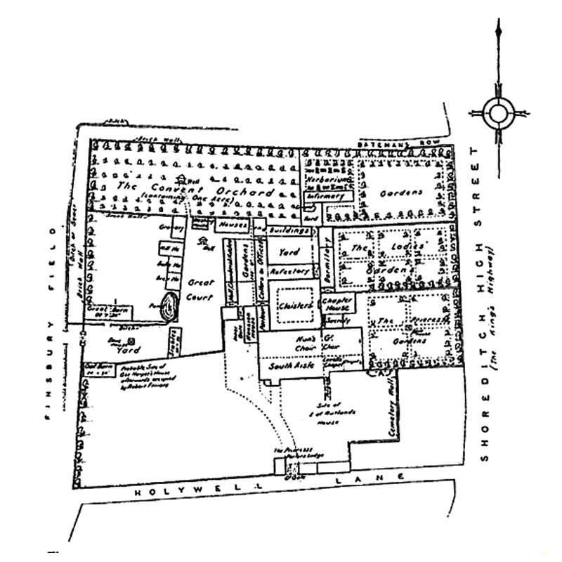
Image copyright © [in the public domain]
CC-PD-Mark
Results: 1 records
view of church exterior in context
Scene Description: Source caption: "A 1544 map showing the details of the agreement between Alice Hampton and Elizabeth Prudde concerning the use of Halliwell Priory."
Copyright Statement: Image copyright © [in the public domain]
Image Source: digital image of a 1544 map in a 1925 book by London County Council [https://commons.wikimedia.org/wiki/File:Halliweel_Priory.png] [accessed 24 May 2019]
Copyright Instructions: CC-PD-Mark
INFORMATION
Font ID: 22171HOL
Object Type: Baptismal Font1?
Font Date: ca. 1233-1250?
Font Century and Period/Style: 12th century (mid?), Late Norman
Church / Chapel Name: Priory Church of St. John the Baptist [disappeared]
Font Location in Church: [disappeared]
Church Patron Saint(s): St. John the Baptist
Church Address: [cf. Directions (Geo)]
Site Location: Greater London, South East, England, United Kingdom
Directions to Site: The site of the medieval priory was located in Holywell Ln, on the W side of Shoreditch, towards Hoxton, within the area now bounded by Batemans Row, Shoreditch High Street, Haliwell Lane and Curtain Road
Ecclesiastic Region: [Diocese of London]
Historical Region: Hundred of Ossulstone -- formerly Middlesex
Additional Comments: disappeared font? (the one from the mid-12thC(?) church here)
Font Notes:
Click to view
No individual entry found for Holywell or variants in the Domesday survey. The Victoria County History (Middlesex, vol. 1, 1969) notes: "The priory of St. John the Baptist at Haliwell, or Holywell, in Shoreditch, although often described both by contemporaries and historians as a Benedictine nunnery was, like the better-known priory of Clerkenwell, a house of Augustinian canonesses. It was one of the larger English nunneries, ranking ninth in wealth—three places higher than Clerkenwell—in the Valor [...] The founder was Robert Fitz Generan (or Gelran) [...] Robert's name occurs from 1133 to 1150. [...] The priory precinct lay within the area now bounded by Batemans Row, Shoreditch High Street, Haliwell Lane, and Curtain Road. [...] No record of the actual dissolution has been found but in 1539 the disposal of the lands was proceeding apace."
COORDINATES
UTM: 30U 702558 5712259
Latitude & Longitude (Decimal): 51.525066, -0.07995
Latitude & Longitude (DMS): 51° 31′ 30.24″ N, 0° 4′ 47.82″ W
REFERENCES
- Victoria County History [online], University of London, 1993-. URL: https://www.british-history.ac.uk.