Tupholme
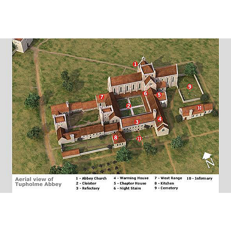
Image copyright © LINCS to the past, 2018
No known copyright restriction / Fair Dealing
Results: 3 records
view of church exterior in context
Scene Description: Source caption: "The attached shows what Tupholme Abbey might have looked like when the canons lived there in the medieval period. It shows how computer reconstructions of the abbey have been produced by bringing together evidence from a number of sources including the standing remains of the abbey and its archaeology, aerial photographs, the remaining loose abbey stone, earthworks survey and information from other monastic sites."
Copyright Statement: Image copyright © LINCS to the past, 2018
Image Source: digital image in LINCS to the past [www.lincstothepast.com/learning-and-resources/learn-about-historic-environment-record/tupholme-abbey-ks23/what-did-tupholme-abbey-look-like/210.article] [accessed 10 May 2019]
Copyright Instructions: No known copyright restriction / Fair Dealing
view of context
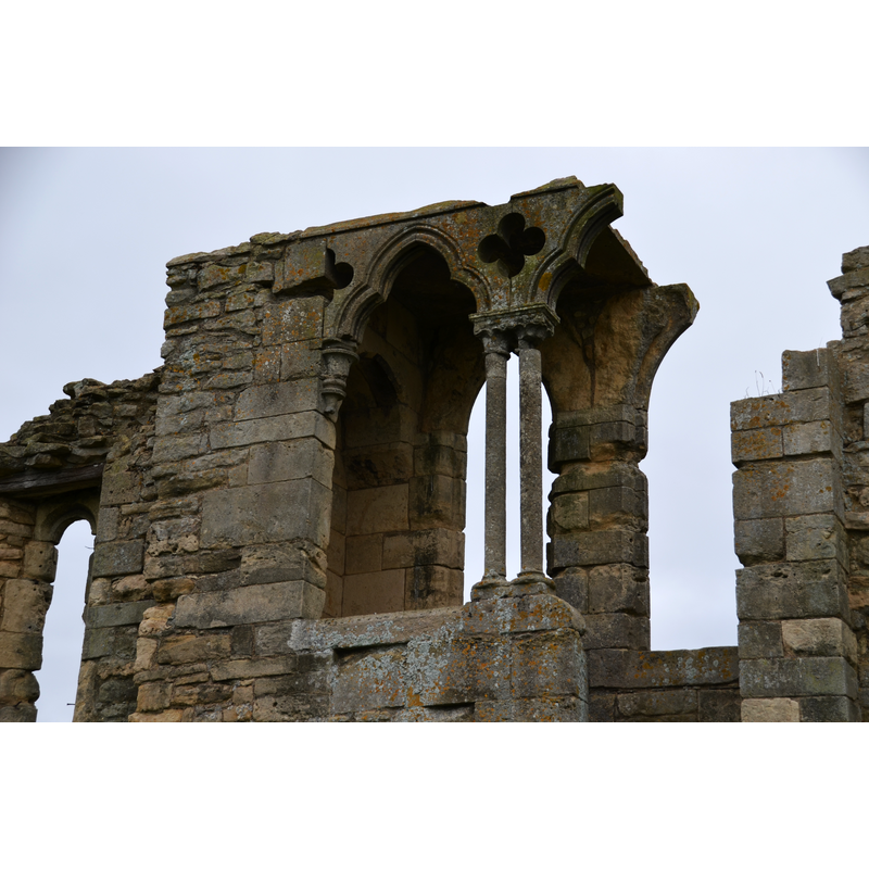
Scene Description: Source caption: "Detail of Tupholme Abbey ruin. Remains of the reader's Pulpit. It is thought that the twin columns were placed here from the original cloisters, to enhance the appearance of the ruin in the grounds of the Vyner's 18th C. house."
Copyright Statement: Image copyright © Julian P Guffogg, 2015
Image Source: digital photograph taken 8 September 2015 by Julian P Guffogg [www.geograph.org.uk/photo/4651384] [accessed 10 May 2019]
Copyright Instructions: CC-BY-SA-2.0
view of context
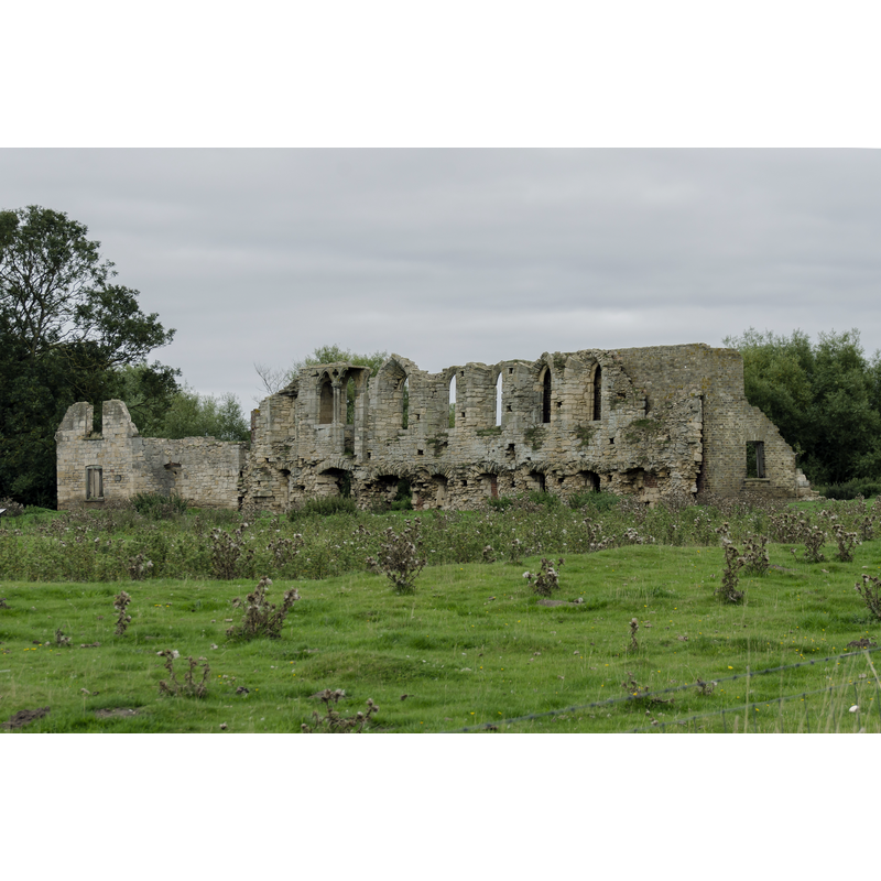
Scene Description: Source caption: "Remains of Tupholme Abbey. A Premonstratensian foundation, one of nine local monasteries, which closed in 1536. Founded in 1160"
Copyright Statement: Image copyright © Julian P Guffogg, 2015
Image Source: digital photograph taken 8 September 2015 by Julian P Guffogg [www.geograph.org.uk/photo/4651378] [accessed 10 May 2019]
Copyright Instructions: CC-BY-SA-2.0
INFORMATION
Font ID: 22145TUP
Object Type: Baptismal Font1?
Font Century and Period/Style: 12th century (late?), Late Norman? / Transitional?
Church / Chapel Name: Abbey Church of the Annunciation
Font Location in Church: [disappeared]
Church Patron Saint(s): The Annunciation to St. Mary
Church Address: [NB: address and coordinates given are for the site and ruins of the abbey: B1190, Lincoln LN3 5TH, UK]
Site Location: Lincolnshire, East Midlands, England, United Kingdom
Directions to Site: The site with ruins of the abbey are located off (just S) the 1190, 2 km SE of Bardney, 17 km ESE of Lincoln city centre
Ecclesiastic Region: [Diocese of Lincoln]
Additional Comments: disappeared font? (the one from the late-12thC abbey church here)
Font Notes:
Click to view
No individual entry found for Tupholme in the Domesday survey. The entry for this Premonstratensian abbey in the Victoria County History (Lincoln, vol. 2, 1906) notes: "The abbey of Tupholme was founded some time before 1190 by Gilbert de Neville and his brother Alan, in honour of the Annunciation [...] The abbey was not very wealthy, but it had sometimes as many as twenty-four canons during the fifteenth century. [...] At the dissolution in 1536 the last abbot received a pension of £18". The entry for this abbey in Historic England [Legacy System number: 30221] notes: "The monument includes the remains of Tupholme Abbey, a Premonstratensian monastery founded between 1155-65 on land granted by Alan and Gilbert de Neville. [...] The abbey was dissolved in 1536 and the property granted to Sir Thomas Heneage of Hainton. Thereafter the site was occupied by a country house, demolished around the beginning of the 18th century and replaced in the 19th century by cottages and a farmhouse, which were themselves dismantled in 1986. The remains of the medieval monastery are therefore intermingled with those of the post-medieval house and farms and the monument includes the earthworks and standing remains of medieval and post-medieval buildings, ponds, ditches and associated features. [...] The northern range of the cloister would originally have been occupied by the monastic church, although no obvious remains of this structure have been identified."
COORDINATES
UTM: 30U 681146 5897842
Latitude & Longitude (Decimal): 53.199, -0.288
Latitude & Longitude (DMS): 53° 11′ 56.4″ N, 0° 17′ 16.8″ W
REFERENCES
- Victoria County History [online], University of London, 1993-. URL: https://www.british-history.ac.uk.