Lincoln No. 9 / Lincolia
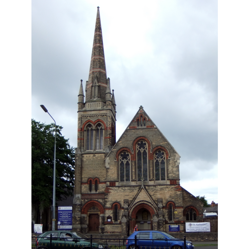
Image copyright © Rept0n1x, 2011
CC-BY-SA-3.0
Results: 1 records
view of church exterior
Scene Description: Source caption: "Former Methodist church in St Katherine's, Lincoln, England,seen from the east". [NB: built on the site of the disappeared medieval priory]
Copyright Statement: Image copyright © Rept0n1x, 2011
Image Source: edited detail of a digital photograph taken 19 June 2011 by Rept0n1x [https://commons.wikimedia.org/wiki/File:St_Katherine's,_Lincoln,_England_-_DSCF1398.JPG] [accessed 6 May 2019]
Copyright Instructions: CC-BY-SA-3.0
INFORMATION
Font ID: 22133LIN
Object Type: Baptismal Font1?
Font Century and Period/Style: 12th century (mid?), Late Romanesque
Church / Chapel Name: Priory Church of St. Katherine outside Lincoln [disappeared]
Font Location in Church: [disappeared]
Church Patron Saint(s): St. Catherine of Alexandria [aka Katherine, Katharine]
Church Address: [NB: address and coordinates are for the present St Katherine's Heritage and Cultural Centre: Colegrave St, South Park, Lincoln LN5 8DW, UK]
Site Location: Lincolnshire, East Midlands, England, United Kingdom
Ecclesiastic Region: [Diocese of Lincoln]
Historical Region: Hundred of Lawress
Additional Comments: disappeared font? (the one from the disappeared mid-12thC priory church here)
Font Notes:
Click to view
There are thirteen entries for Lincoln [variant spelling] in the Domesday survey [https://opendomesday.org/place/SK9771/lincoln/] [accessed 6 May 2019], five of which report a church in them. The entry for this priory in the Victoria County History (Lincoln, vol. 2, 1906) notes: "The Gilbertine priory of St. Catherine, outside Lincoln, was founded by Robert de Chesney, bishop of Lincoln, probably soon after the confirmation of the order of Sempringham by Eugenius III in 1148. [...] The priory was founded as a house for canons, but it seems probable that lay sisters were soon introduced to undertake the care of the sick. St. Gilbert limited the number of women in the house to twenty, while there might be sixteen men [...] The Black Death affected the fortunes of the house very severely. [...] The priory was surrendered on 14 July, 1538". The entry for this priory in the Lincolnshire County Council LINCS to the past [ww.lincstothepast.com/Site-of-St-Catherine-s-Priory-and-St-Sepulchre-s-Hospital--Lincoln/243589.record?pt=S] [accessed 6 May 2019] notes: "Lincoln’s St Sepulchre hospital was founded between 1094 and 1123 for poor and aged sick. It was in the area to the south of Altham Terrace. After 1148 it became a Gilbertine priory dedicated to St Sepulchre and SS James and Catherine for the care of the sick. It was discontinued at the Reformation [...] The priory lands were granted to the Duke of Suffolk after the Dissolution, who promptly sold them to Vincent and Thomas Grantham in 1540. A substantial residence was then established on the site. The artist Buck recorded a sketch of the residence, although a 1779 map by Armstrong records the residence as ruins [...] Remains of significant medieval archaeology clearly associated with the Gilbertine Priory of St Catherine's was revealed in June 2007, during archaeological excavation on land at 45-47 St Catherines, Lincoln (PRN 70401d - SK 9709 6935). The remains comprised a large number of human cist burials and the remains of several structures, representing multiple phases of cemetery use and construction activity. [...] A large stone apsidal building appears to have been constructed on the site shortly afterwards, at some point between the mid 12th to mid 13th century. The building appears to have been quite substantial, with many of the walls being c.1.5m wide, and buttresses used to stabilise the structure. Its form and location would suggest that this structure was a gatehouse chapel, possibly with an attached rectangular nave. [...] The chapel structure appears to have survived until the mid 13th century, when it was demolished and replaced by a similarly built, though much larger building. This replacement building again appears to have functioned as a gatehouse chapel, and is thought to have been in use until around the end of the 14th century. Only a small portion of this building survived within the excavated area". There is an entry for the former Methodist church and the adjoining church hall built on the site of the old prioty in Historic England [Listing NGR: SK9712969559], but there is no mention of any remains from the medieval priory there.
COORDINATES
UTM: 30U 663844 5898943
Latitude & Longitude (Decimal): 53.2145, -0.5462
Latitude & Longitude (DMS): 53° 12′ 52.2″ N, 0° 32′ 46.32″ W
REFERENCES
- Victoria County History [online], University of London, 1993-. URL: https://www.british-history.ac.uk.