Stixwould No. 2 / Stigesuuald / Stigeswalde / Stigeswalt / Stixwold / Stixwould Priory
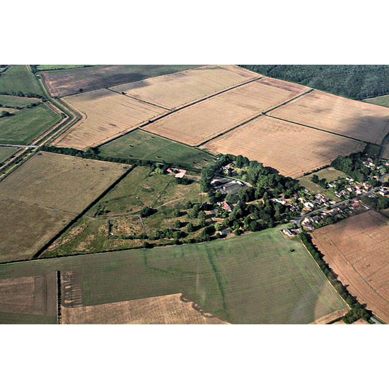
Image copyright © Chris, 2018
CC-BY-SA-2.0
Results: 1 records
view of context
Scene Description: aerial view of the site of the disappeared medieval priory
Copyright Statement: Image copyright © Chris, 2018
Image Source: digital photograph taken 11 July 2018 by Chris [www.geograph.org.uk/photo/5931629] [accessed 25 April 2019]
Copyright Instructions: CC-BY-SA-2.0
INFORMATION
Font ID: 22111STI
Object Type: Baptismal Font1?
Church / Chapel Name: Stixwould Priory [Nunnery] Church [disappeared]
Font Location in Church: [disappeared]
Church Patron Saint(s): St. Mary the Virgin
Church Address: [address of the former priory site: Abbey Farm, Duckpool Ln, Stixwould, Woodhall Spa, LN10 5HR, UK]
Site Location: Lincolnshire, East Midlands, England, United Kingdom
Directions to Site: The former site of the priory is located in what is now Abbey Farm, off (NW) the Main Rd, 300-400 m. WNW of the Stixwould parish church, 4 km NNW of Woohall Spa
Ecclesiastic Region: [Diocese of Lincoln]
Historical Region: Hundred of Gartree
Additional Comments: disappeared font? (the one from the mid-12thC(?) priory church here)
Font Notes:
Click to view
There are three entries for Stixwould [variant spellings] in the Domesday survey [https://opendomesday.org/place/TF1765/stixwould/] [accessed 25 April 2019] none of which mentions cleric or church in it. The entry for this priory in the Victoria County History (Lincoln, vol., 2, 1906) notes that it "was founded by Lucy countess of Chester, [...] who could not possibly have lived far into the reign of Stephen [r. 1135-1154], and may have endowed this house even under Henry I [r. 1100-1135]. [...] The priory of Stixwould had canons and a prior all through the thirteenth century. The last mention we find of them is in 1308. [...] It was liable to episcopal visitation throughout its history [...] As the revenue of the priory was less than £200, it was dissolved under the first Act of Suppression before Michaelmas, 1536", but a little later, on "9 July, 1537, the king issued letters patent for the refoundation of the house under the Premonstratensian rule [...] The 'new monastery of King Henry VIII' was of short duration. On 29 September, 1539, Mary Missenden and her sisters surrendered their priory with all its possessions". The entry for this nunnery in Historic England [Legacy System number: 22606] notes: "Stixwould Priory was founded by Lucy, Countess of Chester, for 20-30 nuns, although through the 13th century there were also canons and a prior. [...] The monument includes the remains of the medieval nunnery of St Mary, Stixwould, a Cistercian nunnery founded in the 12th century and dissolved in 1536. It was immediately refounded as a nunnery of the Benedictine order, and then of the Premonstratensian order (1537), before its final suppression in 1539. The property was then granted to Robert Dighton and in the early 17th century the present farmhouse was constructed on the site. The remains of the nunnery, partly overlain by the post-medieval farmhouse, (which is Listed Grade II), include a building platform, an area of earthworks, moats and associated features, set on an island of higher ground overlooking the Witham flood plain at the western end of the village." The entry for the Abbey Farm House [included here because it is reckoned as having some remains from the medieval priory] in Historic England [Listing NGR: TF1737265995] notes: "Farmhouse. Early C17 incorporating some medieval material from the site of Stixwould Priory behind the house, with C18, C19 and C20 alterations. [...] Throughout the side and rear walls many fragments of medieval masonry, some decorated, are incorporated in the fabric and in the rear wall is a C14 cusped and crocketed niche. The interior retains a fine moulded and stopped beam in the parlour. The roof is of staggered butt purlin construction, with numbered principals, reusing some medieval smoke blackened timbers."
COORDINATES
UTM: 30U 683953 5895687
Latitude & Longitude (Decimal): 53.178692, -0.247281
Latitude & Longitude (DMS): 53° 10′ 43.29″ N, 0° 14′ 50.21″ W
REFERENCES
- Victoria County History [online], University of London, 1993-. URL: https://www.british-history.ac.uk.