Brindle No. 1 / Brumhull / Brunehill / Brunhill / Bryndill / Burnhull / Burnul
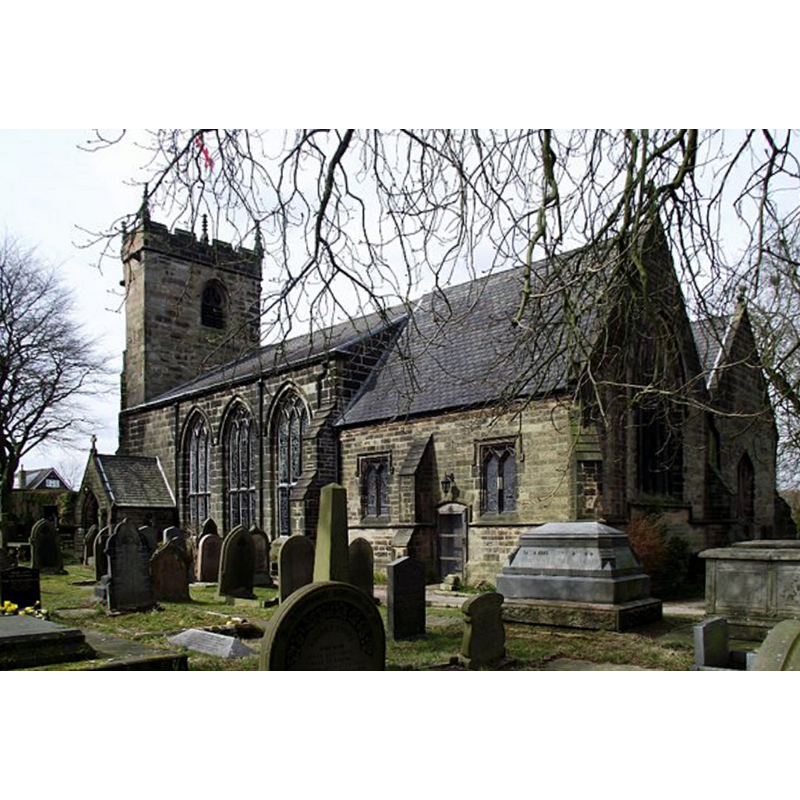
Image copyright © Phil Platt, 2013
CC-BY-SA-2.0
Results: 2 records
view of church exterior - southeast view
Scene Description: Source caption: "St. James' Church, Brindle. Anglican church, parts of which date back to the twelfth century. The church was previously known as St. Helen's."
Copyright Statement: Image copyright © Phil Platt, 2013
Image Source: digital photograph taken 31 March 2013 by Phil Platt [www.geograph.org.uk/photo/3388899] [accessed 12 March 2019]
Copyright Instructions: CC-BY-SA-2.0
view of church interior - nave - looking west
![two fonts have been captured in this image: the one at the far back [west] has a cover on it and is the modern font in use](/static-50478a99ec6f36a15d6234548c59f63da52304e5/compressed/1190313011_compressed.png)
Scene Description: two fonts have been captured in this image: the one at the far back [west] has a cover on it and is the modern font in use
Copyright Statement: Image copyright © Brindle Parish, 2019
Image Source: digital photograph in Brindle Parish web site [http://www.brindlestjames.co.uk/] [accessed 12 March 2019]
Copyright Instructions: No known copyright restriction / Fair Dealing
INFORMATION
Font ID: 22024BRI
Object Type: Baptismal Font1
Font Century and Period/Style: 12th century [basin only], Medieval [composite]
Church / Chapel Name: Parish Church of St. James [originally St. Helen's]
Font Location in Church: Inside the church, at the W end of the nave
Church Patron Saint(s): St. James [originally St. Helen]
Church Notes: church originally dedicated to St,. Helen documented ca. 1190
Church Address: Water St, Brindle, Chorley PR6 8NG, UK
Site Location: Lancashire, North West, England, United Kingdom
Directions to Site: Located off the B5256, SE of the M61-M65 junction, 6-7 km SE of Preston, 10 km WSW of Blackburn
Ecclesiastic Region: Diocese of Blackburn
Historical Region: Hundred of Leyland
Additional Comments: disused font (one of several older disused fonts in this church)
Font Notes:
Click to view
No individual entry for Brindle found in the Domesday survey. Lewis' Dictionary of 1848 reports "an ancient font" in the parsonage [NB: we have no update on this information]. The entry for this parish in the Victoria County History (Lancaster, vol. 6, 1911) notes: "Only the tower and chapel, however, are old, being of 15th-century date, and the latter has been so much restored in recent years as to deprive it of nearly all its archaeological interest. The nave of the old church was pulled down and the present one built in 1817 [...] The font now in use is a modern Gothic one, octagonal in shape, but the church contains three other fonts, and there is a fifth in the rectory garden. Of those in the church the oldest is a circular stone one 2 ft. in diameter, probably of 12th-century date, standing on a made-up base at the west end of the nave. Close to it is a four-sided font with chamfered angles, apparently dating from the early 16th century, having panelled sides, on one of which is the sacred monogram and on another a four-leafed flower. The other two sides are defaced and plain. The remaining font inside the building is a plain 18th-century one on a circular pedestal, but the one in the rectory garden is of greater interest. It is seven-sided and of rough stone, and is only 16 in. in diameter. It was recovered in the village in 1907, and may have belonged to St. Helen's well. The bowl is 12 in. wide and 7 in. deep, and there is no pedestal."
COORDINATES
UTM: 30U 525819 5951706
Latitude & Longitude (Decimal): 53.7134, -2.6088
Latitude & Longitude (DMS): 53° 42′ 48.24″ N, 2° 36′ 31.68″ W
MEDIUM AND MEASUREMENTS
Material: stone
Font Shape: round, mounted
Basin Interior Shape: round
Basin Exterior Shape: round
Diameter (includes rim): 60.96 cm*
Notes on Measurements: * 24 in. in the VCH entry [cf. FontNotes]
REFERENCES
- Victoria County History [online], University of London, 1993-. URL: https://www.british-history.ac.uk.