Thorpe-in-Balne
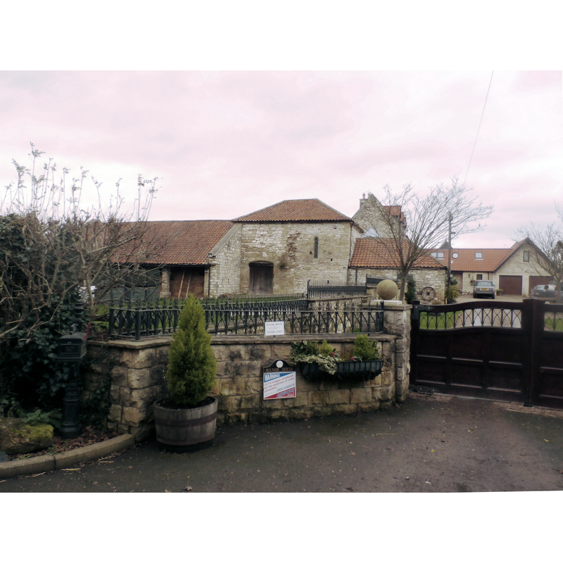
Image copyright © Jonathan Clitheroe, 2015
CC-BY-SA-2.0
Results: 1 records
view of church exterior in context
Scene Description: Source caption: "Manor House, Thorpe in Balne. Remnants of a chapel survive in the fabric of this farm."
Copyright Statement: Image copyright © Jonathan Clitheroe, 2015
Image Source: digital photograph taken 19 December 2015 by Jonathan Clitheroe [www.geograph.org.uk/photo/4772385] [accessed 28 November 2018]
Copyright Instructions: CC-BY-SA-2.0
INFORMATION
Font ID: 21906THO
Object Type: Baptismal Font1?
Font Century and Period/Style: 12th century, Late Norman
Church / Chapel Name: Chapel [at one point parish church]
Font Location in Church: [disappeared]
Church Address: Thorpe Ln, Thorpe in Balne, Doncaster DN5, UK
Site Location: South Yorkshire, Yorkshire and the Humber, England, United Kingdom
Directions to Site: The ruins of the church/chapel are located W of the Thorpe Bank [aka Marsh Rd], W of the River Don, 5 km W of Stainforth, E of the A19
Historical Region: Hundred of Strafforth -- formerly WRYrks
Additional Comments: disappeared font? (the one from the chapel, later parish church here)
Font Notes:
Click to view
No individual entry found for Thorpe-in-Balne in the Domesday survey. The entry for this "moated site, chapel and fishpond" in Historic England [List Entry Number: 1012111] notes: "The Thorpe in Balne example was an important medieval manorial site. Its historical associations are documented and it is unusual in having a medieval chapel on site that was used as the parish church of Thorpe in Balne until the loss of its endowment in 1556. [...] To the south of the house, amongst the farm buildings, is the chancel of a twelfth century chapel, the nave of which was demolished in the nineteenth century. The footings of its south wall, with two buttresses, can be seen in the cow byre. The chapel is thought to have been built by Otto de Tilli who was granted the manor of Thorpe in Balne by William Vavasor in the mid twelfth century." The entry for the remains of the chapel itself [Listing NGR: SE5990511084] notes: "Remains of chapel. C12 with C13, C14/C15 and C19 alterations. [...] C12 north doorway has lintel with arched soffit and plain tympanum beneath semicircular hoodmould [...] Probably founded in mid C12 when William Vavasor gave Thorpe in Balne to Otto de Tilli, the gift being later confirmed by Henry de Laci [...] the nave was described by John Hunter (c.1830). John Hunter, South Yorkshire: The History and Topography of the Deanery of Doncaster, 1831." The entry in the CRSBI (2018) notes: "The chancel of a late 12thc manorial chapel survives in a much altered with further buildings attached to its E and W ends. The buildings are on private property and used largely for farm purposes except for the easternmost section of the chapel, its chancel, where loose sculpture is kept. [...] The chapel is to the S of a modern house which is on the site of the medieval manor house; both lay within a moated site. An archaeological survey of the chapel was done in 1994; restoration followed and was completed in 1997. For full details, see Tomson 1996." [bibliographical reference in the CRSBI: Tomson, Simon J. N. Thorpe-in-Balne Manor Chapel, report for South Yorkshire Archaeological Service 1996 re SMR no. 309 (moated site) and SMR no. 492 (chapel)."]
COORDINATES
UTM: 30U 625948 5939924
Latitude & Longitude (Decimal): 53.593, -1.097
Latitude & Longitude (DMS): 53° 35′ 34.8″ N, 1° 5′ 49.2″ W