Southampton No. 5 / Hamwic / Hantune
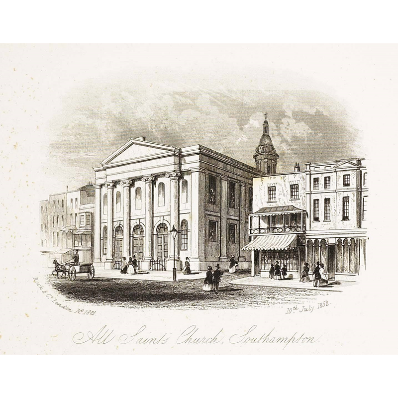
Image copyright © [in the public domain]
CC-PD-Mark / PD-old-70-1923
Results: 2 records
view of church exterior in context - southwest view
Scene Description: All Saints [aka All Hallows] was demolished in 1791
Copyright Statement: Image copyright © [in the public domain]
Image Source: digital image of a 10 July 1852 illustration in William Frederick Rock, Rock & Co. London. No. 1881 All Saints Church, Southampton. 10 Jul 1852. (Collection/Location: North Devon Athenaeum). [https://commons.wikimedia.org/wiki/File:All_Saints_Church,_Southampton,_1852.jpg] [accessed 30 July 2018]
Copyright Instructions: CC-PD-Mark / PD-old-70-1923
view of church interior - nave - looking east
![All Saints [aka All Hallows] was demolished in 1791](/static-50478a99ec6f36a15d6234548c59f63da52304e5/compressed/0180803024_compressed.png)
Scene Description: All Saints [aka All Hallows] was demolished in 1791
Copyright Statement: Image copyright © [in the public domain]
Image Source: digital image of a 1910 Postcard showing the interior of All Saint's Church in Southampton, by George Whitfield Cosser (1876-1918) [https://commons.wikimedia.org/wiki/File:All_Saints'_Church,_Southampton,_Interior.JPG] [accessed 30 July 2018]
Copyright Instructions: CC-PD-Mark / PD-old-70-1923
INFORMATION
Font ID: 21775SOU
Object Type: Baptismal Font1?
Font Century and Period/Style: 12th century (late?), Late Norman
Church / Chapel Name: Parish Church of All Saints [aka All Hallows] [demolished 1791]
Font Location in Church: [disappeared]
Church Notes: late-12thC church demolished 1791; re-built 1795; badly damaged in WWII; demolished soon thereafter [ca. 1945?]
Church Address: the church was located on the corner of the High Street and East Street
Site Location: Hampshire, South East, England, United Kingdom
Directions to Site: Located off the A33. The church was located at the High St and East St crossing
Ecclesiastic Region: Diocese of Winchester
Historical Region: Hundred of Mansbridge
Additional Comments: disappeared font? (the one from the original late-12thC church here)
Font Notes:
Click to view
There are four entries for Southampton [variant spelling] in the Domesday survey [http://opendomesday.org/place/SU4111/southampton/] [accessed 30 July 2019], one of which reports "3 churches. 1.0 church lands" in it. The entry for this parish in the Victoria County History (Hampshire, vol. 3, 1908) notes: "The church of this parish was originally in the patronage of the convent of St. Denys [...] is not mentioned in the Taxation of 1291 but a settled pension there of £1 6s. 8d. yielded its tenth of 2s. 3d. In 1428 its annual value was stated at 6 marks. [...] The fabric having become ruinous and the accommodation being insufficient, the church was rebuilt on an enlarged scale under certain authorities [...] in 1792, and consecrated on 12 November, 1795." The later church was demolished after being damaged in WWII.
COORDINATES
UTM: 30U 612218 5640120
Latitude & Longitude (Decimal): 50.90182, -1.40409
Latitude & Longitude (DMS): 50° 54′ 6.55″ N, 1° 24′ 14.72″ W
REFERENCES
- Victoria County History [online], University of London, 1993-. URL: https://www.british-history.ac.uk.