Hartest
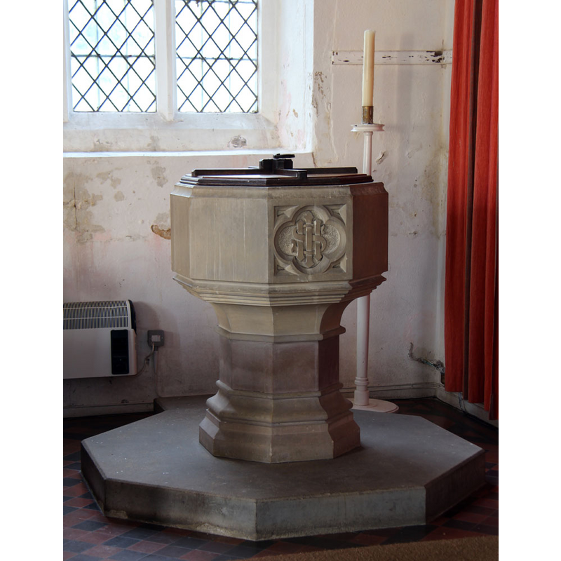
Image copyright © John Salmon, 2013
CC-BY-SA-2.0
Results: 4 records
view of font and cover in context
Scene Description: the modern font
Copyright Statement: Image copyright © John Salmon, 2013
Image Source: digital photograph taken 19 February 2013 by John Salmon [www.geograph.org.uk/photo/3341967] [accessed 13 June 2018]
Copyright Instructions: CC-BY-SA-2.0
view of church exterior - south view
![EXT S digital photograph taken 19 February 2013 by John Salmon [www.geograph.org.uk/photo/3341939] [accessed 13 June 2018]
INT E digital photograph taken 19 February 2013 by John Salmon [www.geograph.org.uk/photo/3341943] [accessed 13 June 2018]
INT W digital photograph taken 19 February 2013 by John Salmon [www.geograph.org.uk/photo/3341949] [accessed 13 June 2018]
MOD FONT digital photograph taken 19 February 2013 by John Salmon [www.geograph.org.uk/photo/3341967] [accessed 13 June 2018]](/static-50478a99ec6f36a15d6234548c59f63da52304e5/compressed/1180612090_compressed.png)
Scene Description: EXT S digital photograph taken 19 February 2013 by John Salmon [www.geograph.org.uk/photo/3341939] [accessed 13 June 2018]
INT E digital photograph taken 19 February 2013 by John Salmon [www.geograph.org.uk/photo/3341943] [accessed 13 June 2018]
INT W digital photograph taken 19 February 2013 by John Salmon [www.geograph.org.uk/photo/3341949] [accessed 13 June 2018]
MOD FONT digital photograph taken 19 February 2013 by John Salmon [www.geograph.org.uk/photo/3341967] [accessed 13 June 2018]
Copyright Statement: Image copyright © John Salmon, 2013
Image Source: digital photograph taken 19 February 2013 by John Salmon [www.geograph.org.uk/photo/3341939] [accessed 13 June 2018]
Copyright Instructions: CC-BY-SA-2.0
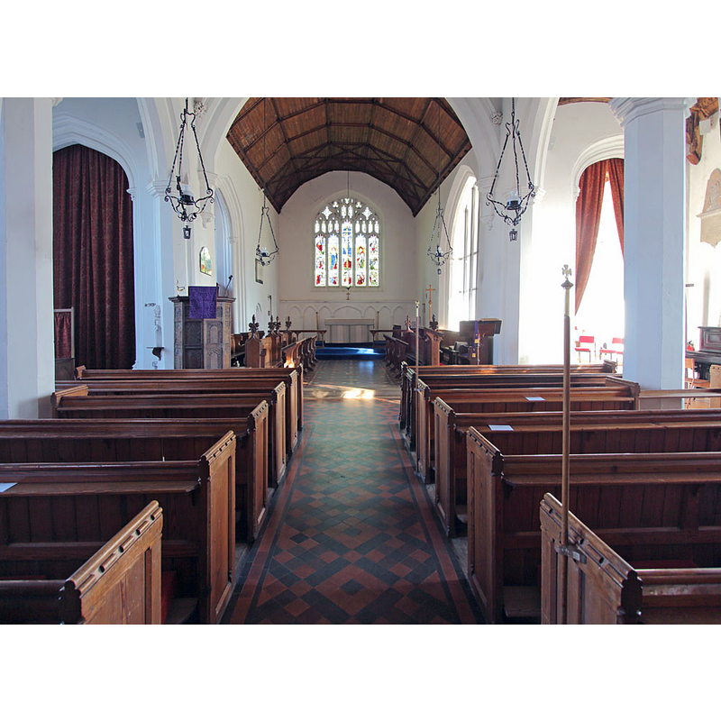
view of church interior - nave - looking west
Copyright Statement: Image copyright © John Salmon, 2013
Image Source: digital photograph taken 19 February 2013 by John Salmon [www.geograph.org.uk/photo/3341949] [accessed 13 June 2018]
Copyright Instructions: CC-BY-SA-2.0
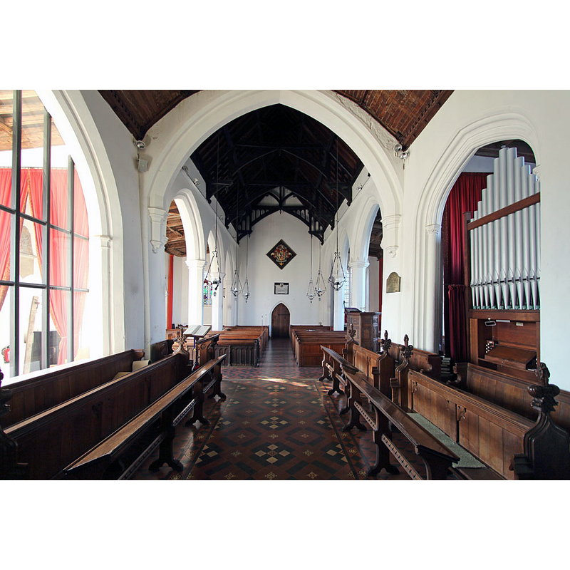
view of church interior - nave - looking east
Copyright Statement: Image copyright © John Salmon, 2013
Image Source: digital photograph taken 19 February 2013 by John Salmon [www.geograph.org.uk/photo/3341943] [accessed 13 June 2018]
Copyright Instructions: CC-BY-SA-2.0
INFORMATION
Font ID: 21752HAR
Object Type: Baptismal Font1?
Font Century and Period/Style: 11th century, Pre-Conquest? / Norman
Church / Chapel Name: Parish Church of All Saints
Font Location in Church: [cf. FontNotes]
Church Patron Saint(s): All Saints
Church Address: Hartest, Bury Saint Edmunds IP29 4DH, UK -- Tel.: +44 1787 282164
Site Location: Suffolk, East Anglia, England, United Kingdom
Directions to Site: Hartest is located up the B1066, 2 km NNE of Boxted, both of them SSW of Bury St Edmunds
Ecclesiastic Region: Diocese of St.Edmundsbury & Ipswich
Historical Region: Hundred of Babergh
Additional Comments: disappeared font? (the one from the Domesday-time church here)
Font Notes:
Click to view
[NB: there seems to be some confusion in listing Hartest All Saints and Boxted Holy Trinity churches -- the Church of England site
notes: "All Saints Hartest is unusual in that it sits in the lowest part of the village. If you have problems finding it just look for the Crown public house and we are to its left. Holy Trinity Boxted has been linked with All Saints for over a thousand years, but retains its own character and unique features."] There are two entries for Hartest in the Domesday survey [http://opendomesday.org/place/TL8352/hartest/] [accessed 13 June 2018], one of which mentions "1 church. 0.66 church lands" in it. Knott (2008) [www.suffolkchurches.co.uk/hartest.html] [www.flickr.com/photos/norfolkodyssey/2418735660/] [accessed 13 June 2018] mentions and illustrates a new font of the 19th century in this church, octagonal basin, base and plinth, with Christ's symbol on one of the panes of the basin. The entry for this church in Historic England [Listing NGR: TL8346952388] mentions no font in it.
notes: "All Saints Hartest is unusual in that it sits in the lowest part of the village. If you have problems finding it just look for the Crown public house and we are to its left. Holy Trinity Boxted has been linked with All Saints for over a thousand years, but retains its own character and unique features."] There are two entries for Hartest in the Domesday survey [http://opendomesday.org/place/TL8352/hartest/] [accessed 13 June 2018], one of which mentions "1 church. 0.66 church lands" in it. Knott (2008) [www.suffolkchurches.co.uk/hartest.html] [www.flickr.com/photos/norfolkodyssey/2418735660/] [accessed 13 June 2018] mentions and illustrates a new font of the 19th century in this church, octagonal basin, base and plinth, with Christ's symbol on one of the panes of the basin. The entry for this church in Historic England [Listing NGR: TL8346952388] mentions no font in it.
COORDINATES
UTM: 31U 341236 5779068
Latitude & Longitude (Decimal): 52.13928, 0.68
Latitude & Longitude (DMS): 52° 8′ 21.41″ N, 0° 40′ 48″ E