Kolbsheim / Colobocisheim
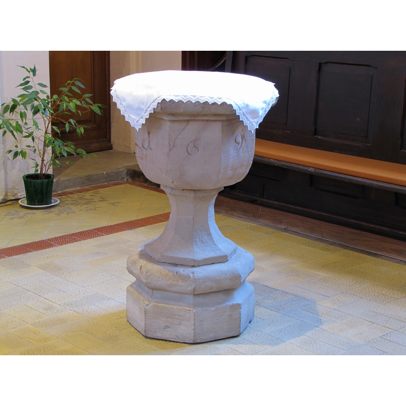
Image copyright © Ralph Hammann, 2015
CC-BY-SA-4.0
Results: 4 records
view of font
Copyright Statement: Image copyright © Ralph Hammann, 2015
Image Source: digital photograph taken 1 April 2015 by Ralph Hammann [https://commons.wikimedia.org/wiki/File:Kolbsheim_StLéger_21.JPG] [accessed 25 February 2018]
Copyright Instructions: CC-BY-SA-4.0
view of church exterior in context - northwest view
![Source caption: "Église simultanée Saint-Léger de Kolbsheim [...] Ancien cimetière sur l'emplacement de l'ancienne église".](/static-50478a99ec6f36a15d6234548c59f63da52304e5/compressed/1180225015_compressed.png)
Scene Description: Source caption: "Église simultanée Saint-Léger de Kolbsheim [...] Ancien cimetière sur l'emplacement de l'ancienne église".
Copyright Statement: Image copyright © Ralph Hammann, 2015
Image Source: digital photograph taken 1 April 2015 by Ralph Hammann [https://commons.wikimedia.org/wiki/File:Kolbsheim_StLéger_52.JPG] [accessed 25 February 2018]
Copyright Instructions: CC-BY-SA-4.0
view of church interior - nave - looking west
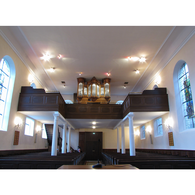
Copyright Statement: Image copyright © Ralph Hammann, 2015
Image Source: digital photograph taken 1 April 2015 by Ralph Hammann [https://commons.wikimedia.org/wiki/File:Kolbsheim_StLéger_34.JPG] [accessed 25 February 2018]
Copyright Instructions: CC-BY-SA-4.0
view of church interior - nave - looking east
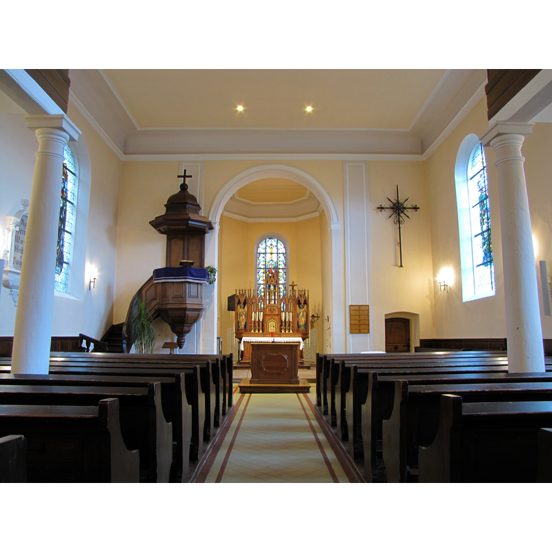
Copyright Statement: Image copyright © Ralph Hammann, 2015
Image Source: digital photograph taken 1 April 2015 by Ralph Hammann [https://commons.wikimedia.org/wiki/File:Kolbsheim_StLéger_01.JPG] [accessed 25 February 2018]
Copyright Instructions: CC-BY-SA-4.0
INFORMATION
Font ID: 21632KOL
Object Type: Baptismal Font1
Font Date: 1691
Font Century and Period/Style: 17th century(late), Renaissance
Church / Chapel Name: Église Saint-Léger [with 'simultaneum' since 1691]
Font Location in Church: Inside the church
Church Patron Saint(s): St. Leger [aka Ledger, Léger, Leodegar, Leodegarius]
Church Notes: present church of 1768 built on a different site to replace the earlier church demolished in 1768; listed in Mérimée [ref.: IA00023189]: "Temple construit sur un nouvel emplacement en 1768 pour remplacer l'ancienne église devenue vétuste ; il est construit d'après des plans de Le Mire, conservés aux archives paroissiales, dates 1766 et 1767 ; les travaux sont exécutés par Jean Michel Ruescher maître maçon et Jean Georges Kappler charpentier ; la nef est à la charge de la communauté protestante et du seigneur le baron de Falckenhayn, le choeur est à la charge du décimateur le grand chapitre de la cathédrale de Strasbourg et réservé aux catholiques ; le campanile est construit en 1870".
Church Address: rue de la Division Leclerc, 67120 Kolbsheim, France
Site Location: Bas-Rhin, Grand Est, France, Europe
Directions to Site: Located off the D93-D111 crossroads, WSW of Strasbourg [merged with Duppigheim since 1983]
Ecclesiastic Region: Diocèse de Strasbourg
Historical Region: Alsace
Font Notes:
Click to view
A plan of the old church executed before the 1768 demolition [http://notices-patrimoine.region-alsace.eu/noticespdf/ia00024131.pdf] [accessed 25 February 2018] shows a baptismal font by the north side of the chancel arch; the plan appears to be the only visual evidence that remains from the old church. The font is listed in Palissy [ref.: IM67000268]: "fonts baptismaux [grès] plan (octogonal) [...] 1691".
COORDINATES
Latitude & Longitude (DMS): 48° 33′ 36″ N, 7° 35′ 10″ E
MEDIUM AND MEASUREMENTS
Material: stone, sandstone
Font Shape: octagonal, mounted
Basin Interior Shape: round
Basin Exterior Shape: octagonal
INSCRIPTION
Inscription Language: numbers
Inscription Location: on the basin sides
Inscription Text: "1691"
Inscription Notes: [cf. FontNotes]
Inscription Source: [cf. FontNotes]
REFERENCES
- France, Ministère de la culture, Inventaire Général, Palissy (France, Ministère de la culture), France, Ministère de la culture. URL: http://www.culture.fr/public/mistral/palissy.