Sorup No. 2 / Sørup / Sörup / Sörup in Angeln
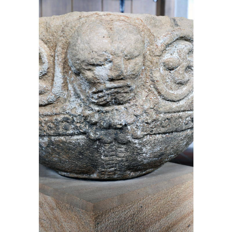
Image copyright © Baptisteria Sacra Index, 2024
CC-BY-NC-ND-4.0
Results: 10 records
human figure - grotesque or fantastic?
Scene Description: one of the humanoid heads
Copyright Statement: Image copyright © Baptisteria Sacra Index, 2024
Image Source: digital photograph taken 17 May 2023 by BSI
Copyright Instructions: CC-BY-NC-ND-4.0
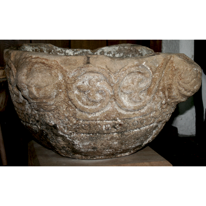
view of basin - detail
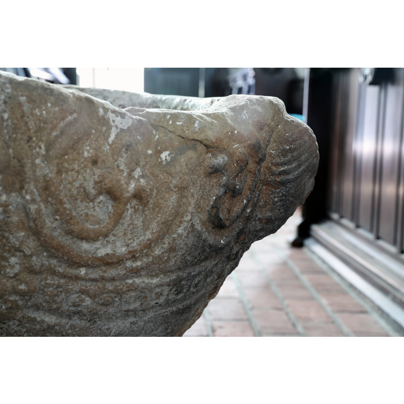
Copyright Statement: Image copyright © Baptisteria Sacra Index, 2024
Image Source: digital photograph taken 17 May 2023 by BSI
Copyright Instructions: CC-BY-NC-ND-4.0
design element - motifs - vine
Scene Description: two large circles on each side, between the heads
Copyright Statement: Image copyright © Baptisteria Sacra Index, 2024
Image Source: digital photograph taken 17 May 2023 by BSI
Copyright Instructions: CC-BY-NC-ND-4.0
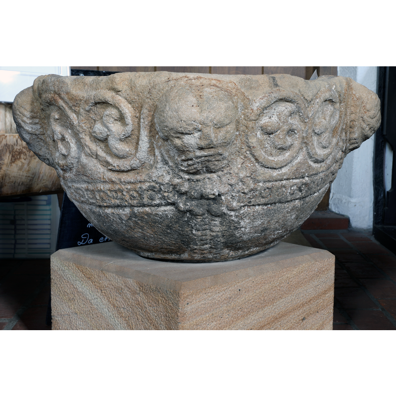
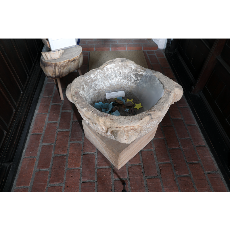
view of basin - upper view
Copyright Statement: Image copyright © Baptisteria Sacra Index, 2024
Image Source: digital photograph taken 17 May 2023 by BSI
Copyright Instructions: CC-BY-NC-ND-4.0
view of basin - upper view
Copyright Statement: Image copyright © Baptisteria Sacra Index, 2024
Image Source: digital photograph taken 17 May 2023 by BSI
Copyright Instructions: CC-BY-NC-ND-4.0
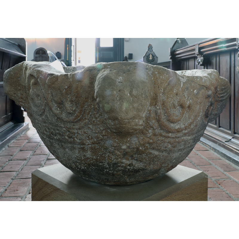
view of font
Copyright Statement: Image copyright © Agnete, 2013
Image Source: digital photograph taken 12 July 2013 by Agnete [https://commons.wikimedia.org/wiki/File:Sörup_Weihwasserbecken.jpg] [accessed 13 January 2018]
Copyright Instructions: CC-BY-SA-3.0
human figure - head - 4
Scene Description: at 90-degree angles; some human or fumanoid? / some animal?
Copyright Statement: Image copyright © Agnete, 2013
Image Source: digital photograph taken 12 July 2013 by Agnete [https://commons.wikimedia.org/wiki/File:Sörup_Weihwasserbecken.jpg] [accessed 13 January 2018]
Copyright Instructions: CC-BY-SA-3.0
design element - motifs - circle
Scene Description: on a flat moulding or band, all around
Copyright Statement: Image copyright © Agnete, 2013
Image Source: digital photograph taken 12 July 2013 by Agnete [https://commons.wikimedia.org/wiki/File:Sörup_Weihwasserbecken.jpg] [accessed 13 January 2018]
Copyright Instructions: CC-BY-SA-3.0
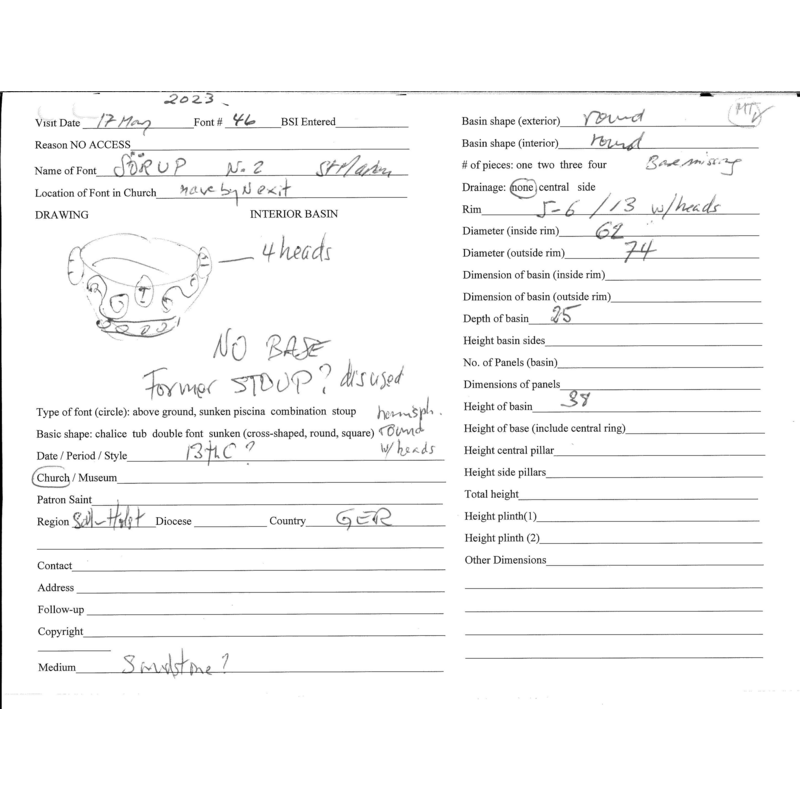
information
Copyright Statement: Image copyright © Baptisteria Sacra Index, 2025
Image Source: Field notes taken on site by BSI
Copyright Instructions: CC-BY-NC-ND-4.0
view of font
Copyright Statement: Image copyright © Baptisteria Sacra Index, 2024
Image Source: digital photograph taken 17 May 2023 by BSI
Copyright Instructions: CC-BY-NC-ND-4.0
INFORMATION
Font ID: 21598SOR
Object Type: Stoup
Date Visited: 2023-05-17
Font Century and Period/Style: 12th - 13th century, Romanesque
Church / Chapel Name: Evangelisch-lutherischen St. Marien-Kirche
Font Location in Church: Inside the church, in the nave, by the N exit
Church Patron Saint(s): St. Mary the Virgin
Church Address: Schulstraße 1, 24966 Sörup, Germany
Site Location: Schleswig-Flensburg, Schleswig-Holstein, Germany, Europe
Directions to Site: Located near Munkbrarup, 17 km SE of Flensburg, 23 km NE of Schleswig
Historical Region: Angeln (Halbinsel) / Angel
Font Notes:
Click to view
On-site notes: a very battered hemispherical-shaped basin now used as holy-water stoup; it may have originally been a font; it has four protruding animal heads at 90-degree angles, some too eroded or damaged for identification; between them are roundels of a large vine; below those is a flat moulding on which appears to be carved foliage, again, much eroded now.
COORDINATES
UTM: 32U 543071 6063305
Latitude & Longitude (Decimal): 54.7152, 9.6686
Latitude & Longitude (DMS): 54° 42′ 54.72″ N, 9° 40′ 6.96″ E
MEDIUM AND MEASUREMENTS
Material: stone
Font Shape: hemispheric
Basin Interior Shape: round
Basin Exterior Shape: round
Rim Thickness: 5-6 cm* [13 cm* max]
Diameter (inside rim): 62 cm*
Diameter (includes rim): 74 cm*
Basin Depth: 25 cm*
Basin Total Height: 38 cm*
Notes on Measurements: * BSI on-site