Grandes-Chapelles No. 2 / Les Grandes-Chapelles
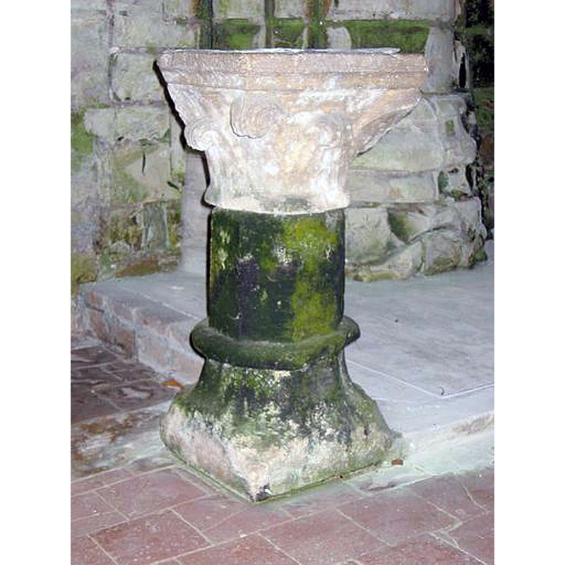
Image copyright © Ministère de la Culture, 2003; Conseil régional de Champagne-Ardenne, 2003; Conseil général de l'Aube, 2003
CC-BY-SA-NC-ND 4.0 = Licence Ouverte / CC-BY-SA-4.0
Results: 1 records
view of stoup
Scene Description: a re-cycled 14thC capital
Copyright Statement: Image copyright © Ministère de la Culture, 2003; Conseil régional de Champagne-Ardenne, 2003; Conseil général de l'Aube, 2003
Image Source: photograph 2003 by Phot. D. Mercier ; Phot. E. Ernest in Mémoire [OA010031025843] [www.culture.gouv.fr/Wave/image/memoire/1503/oa010_031025843nuca_p.jpg] [accessed 26 March 2016]
Copyright Instructions: CC-BY-SA-NC-ND 4.0 = Licence Ouverte / CC-BY-SA-4.0
INFORMATION
Font ID: 20466CHA
Object Type: Stoup
Object Details: capital
Font Century and Period/Style: 14th century, Gothic
Church / Chapel Name: Église paroissiale Saint Pierre et Saint Paul
Font Location in Church: Inside the church
Church Patron Saint(s): St. Peter & St. Paul
Church Notes: 12th, 16thC church listed in Mérimée [ref.: PA00078118]
Church Address: 10170 Les Grandes-Chapelles, France
Site Location: Aube, Grand Est, France, Europe
Directions to Site: Located off the D31 [aka rue de Rilly-rue d'Arcis], NNW of Troyes
Ecclesiastic Region: Diocèse de Troyes
Additional Comments: re-cycled stoup (not known when the former capital was re-carved)
Font Notes:
Click to view
Composite holy-water stoup re-cycled from a former 14th-century capital. Listed in Palissy [ref.: PM10000875]: "Bénitier [calcaire], creusé dans un chapiteau déposé, pierre, 14e siècle [...] mauvaises conditions de conservation ; altération biologique de la matière".
COORDINATES
UTM: 31U 575168 5368729
Latitude & Longitude (Decimal): 48.4646, 4.01763
Latitude & Longitude (DMS): 48° 27′ 52.56″ N, 4° 1′ 3.47″ E
MEDIUM AND MEASUREMENTS
Material: stone, limestone
Font Shape: square, mounted
Basin Interior Shape: round
Basin Exterior Shape: square
REFERENCES
- France, Ministère de la culture, Inventaire Général, Mémoire / POP : la plateforme ouverte du patrimoine (Ministère de la culture, Inventaire Général), 2024. URL: https://www.pop.culture.gouv.fr/search/mosaic?base=%5B%22Photographies%20%28M%C3%A9moire%29%22%5D.
- France, Ministère de la culture, Inventaire Général, Palissy (France, Ministère de la culture), France, Ministère de la culture. URL: http://www.culture.fr/public/mistral/palissy.