Sanderstead / Sandestede / Sonderstade
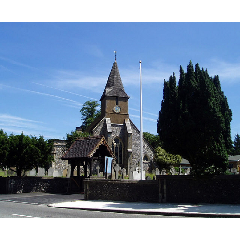
Image copyright © Nigel Freeman, 2005
CC-BY-SA-2.0
Results: 4 records
view of church exterior - west view
Copyright Statement: Image copyright © Nigel Freeman, 2005
Image Source: digital photograph taken 19 June 2005 by Nigel Freeman [www.geograph.org.uk/photo/19905] [accessed 21 March 2016]
Copyright Instructions: CC-BY-SA-2.0
view of church exterior - southwest view
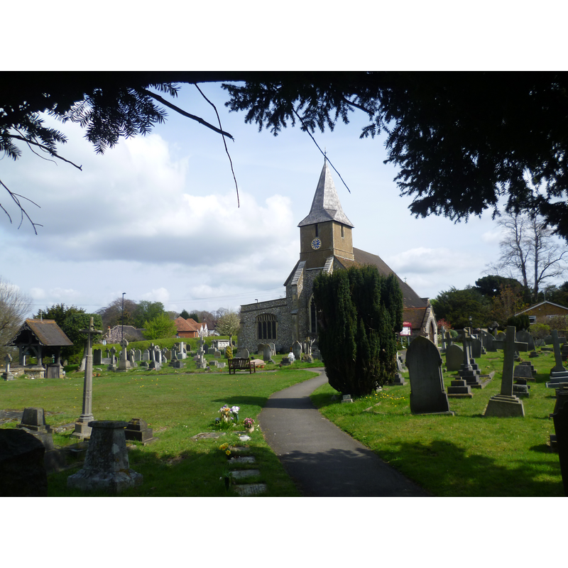
Scene Description: Source caption: "All Saints Church, Sanderstead. This is the approach to All Saints Church from Onslow Gardens. In 1801 the Parish of Sanderstead, centred on All Saints Church, had a population of 204 and was described as ‘an idyllic village with herdsmen, some cottages, woods, fields finely cultivated and sheep walks well stocked and with distant views of the Royal Castle of Windsor’. The churchyard of All Saints Church stands on the summit of Sanderstead Hill at 596 feet above sea level. There is a tradition that there was a Saxon church on the site but the present church was begun in about 1230, with the tower added about 1310."
Copyright Statement: Image copyright © Marathon, 2012
Image Source: digital photograph taken 14 April 2012 by Marathon [www.geograph.org.uk/photo/2899488] [accessed 21 March 2016]
Copyright Instructions: CC-BY-SA-2.0
view of church interior - north aisle - looking west
![Source caption: "All Saints church, Sanderstead: north aisle. The north aisle of the church was added in the 19th century." -- the basin and cover of the modern font are visible at the far [west] end, behind the bank of benches, near the window](/static-50478a99ec6f36a15d6234548c59f63da52304e5/compressed/1160321012_compressed.png)
Scene Description: Source caption: "All Saints church, Sanderstead: north aisle. The north aisle of the church was added in the 19th century." -- the basin and cover of the modern font are visible at the far [west] end, behind the bank of benches, near the window
Copyright Statement: Image copyright © Stephen Craven, 2010
Image Source: digital photograph taken 11 November 2010 by Stephen Craven [www.geograph.org.uk/photo/2158059] [accessed 21 March 2016]
Copyright Instructions: CC-BY-SA-2.0
view of church interior - chancel and east end
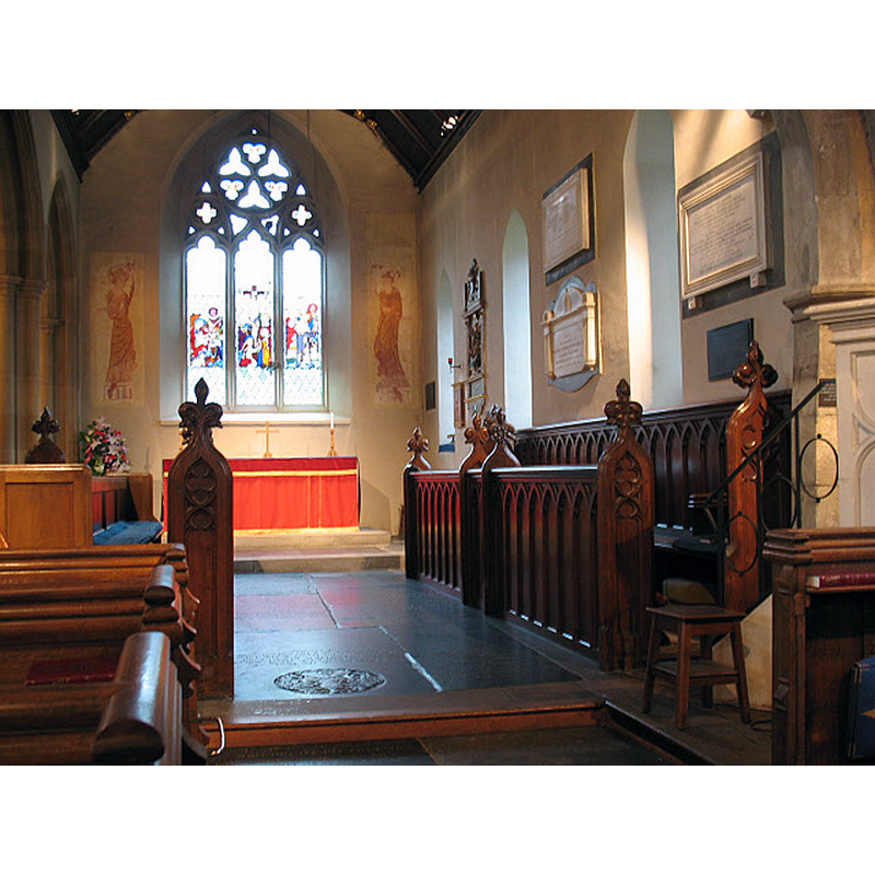
Scene Description: Source caption: "All Saints church, sanderstead: chancel. The chancel is 14th century in origin, but restored in its present form in 1832. The church has ancient origins and is grade I listed."
Copyright Statement: Image copyright © Stephen Craven, 2010
Image Source: digital photograph taken 11 November 2010 by Stephen Craven [www.geograph.org.uk/photo/2158057] [accessed 21 March 2016]
Copyright Instructions: CC-BY-SA-2.0
INFORMATION
Font ID: 20444SAN
Object Type: Baptismal Font1?
Font Century and Period/Style: 13th century, Medieval
Church / Chapel Name: Parish Church of All Saints
Church Patron Saint(s): All Saints
Church Address: 3 A2022, Sanderstead, Croydon, Greater London CR2 8RE
Site Location: Greater London, South East, England, United Kingdom
Directions to Site: Located off (S) Addington Rd, E of the B269, E of Purley, 5 km SSE of Croydon, in the London Borough of Croydon
Ecclesiastic Region: Diocese of Southwark
Historical Region: Hundred of Wallington -- formerly in Surrey
Additional Comments: disappeared font? (the one from the 13thC church here)
Font Notes:
Click to view
There is an entry for Sanderstead [variant spelling] in the Domesday survey [http://opendomesday.org/place/TQ3461/sanderstead/] [accessed 21 March 2016], but it mentions neither cleric nor church in it. The Victoria County History (Surrey, vol. 4, 1912) notes: " Although some axe tooling on the stones at the east end of the north aisle suggests an earlier date, the present church was begun about 1230"; it reports a modern font here. The modern font is located at the west end of the north aisle.
COORDINATES
UTM: 30U 703647 5691236
Latitude & Longitude (Decimal): 51.335885, -0.076348
Latitude & Longitude (DMS): 51° 20′ 9.19″ N, 0° 4′ 34.85″ W
REFERENCES
- Victoria County History [online], University of London, 1993-. URL: https://www.british-history.ac.uk.