Roderwolde / Rowol
Image copyright © Protestantse gemeente te Roden-Roderwolde, 2016
No known copyright restriction / Fair Dealing
Results: 10 records
view of font
Scene Description: now in the modern church of 1831
Copyright Statement: Image copyright © Protestantse gemeente te Roden-Roderwolde, 2016
Image Source: digital photograph in the Protestantse gemeente te Roden-Roderwolde [www.pkn-roden.nl/images/stories/Historie_kerken/jacobskerk/doopvont.jpg] [accessed 5 February 2016]
Copyright Instructions: No known copyright restriction / Fair Dealing
design element - motifs - moulding - parallel - 2
Scene Description: torus-scotia-torus
Copyright Statement: Image copyright © Protestantse gemeente te Roden-Roderwolde, 2016
Image Source: digital photograph in the Protestantse gemeente te Roden-Roderwolde [www.pkn-roden.nl/images/stories/Historie_kerken/jacobskerk/doopvont.jpg] [accessed 5 February 2016]
Copyright Instructions: No known copyright restriction / Fair Dealing
design element - motifs - braid - 2-strand
Copyright Statement: Image copyright © Protestantse gemeente te Roden-Roderwolde, 2016
Image Source: digital photograph in the Protestantse gemeente te Roden-Roderwolde [www.pkn-roden.nl/images/stories/Historie_kerken/jacobskerk/doopvont.jpg] [accessed 5 February 2016]
Copyright Instructions: No known copyright restriction / Fair Dealing
design element - motifs - piping - 8
Copyright Statement: Image copyright © Protestantse gemeente te Roden-Roderwolde, 2016
Image Source: digital photograph in the Protestantse gemeente te Roden-Roderwolde [www.pkn-roden.nl/images/stories/Historie_kerken/jacobskerk/doopvont.jpg] [accessed 5 February 2016]
Copyright Instructions: No known copyright restriction / Fair Dealing
view of church exterior
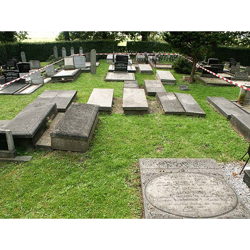
Scene Description: the red-tape outlines the perimeter of the old church foundations, which lay intact just 50 cm. below ground level.in the present cemetery -- Source caption: "In 2002 is door een groepje enthousiaste Rowolmers een oppervlakkig onderzoek verricht naar de fundamenten van de oude kerk. Deze liggen nog steeds ongeschonden omstreeks 50 cm. onder het maaiveld, waardoor de exacte ligging van de kerk midden op het kerkhof gemakkelijk valt te traceren. Op deze opname laat het rode lint de omtrek van de kerk zien, gericht naar het oosten."
Copyright Statement: Image copyright © Protestantse gemeente te Roden-Roderwolde, 2016
Image Source: digital photograph in the Protestantse gemeente te Roden-Roderwolde [www.pkn-roden.nl/images/stories/Historie_kerken/jacobskerk/fundering.jpg] [accessed 5 February 2016]
Copyright Instructions: No known copyright restriction / Fair Dealing
view of church exterior - southwest view
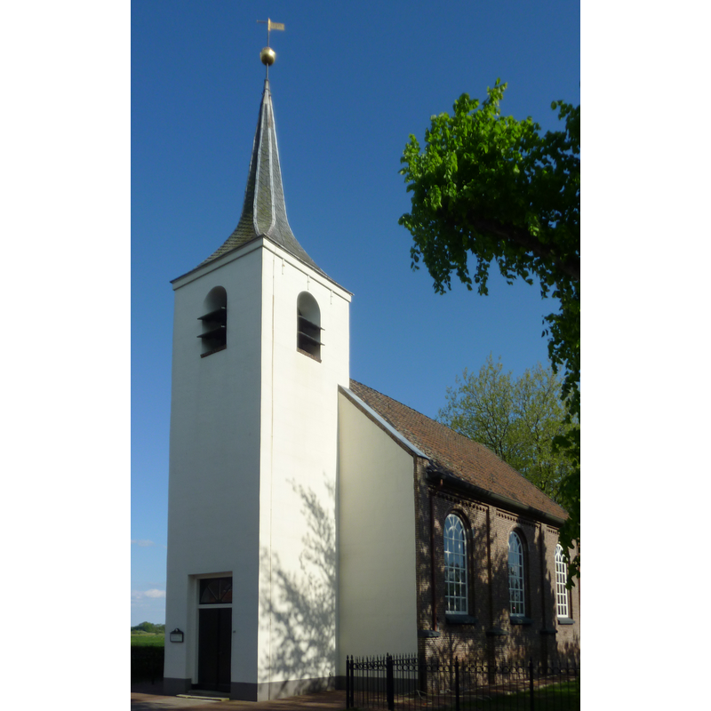
Scene Description: the modern church of 1831
Copyright Statement: Image copyright © Fransvannes, 2011
Image Source: edited detail of a digital photograph taken 1 May 2011 by Fransvannes [https://commons.wikimedia.org/wiki/File:Roderwolde1.jpg] [accessed 5 February 2016]
Copyright Instructions: CC-BY-SA-3.0
view of church exterior - detail
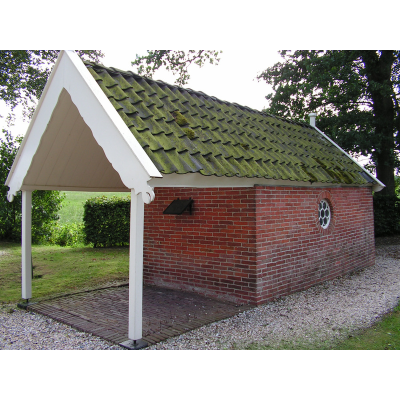
Scene Description: the shelter ca. 2013; the font had already been removed to the new church
Copyright Statement: Image copyright © groninganus, 2013
Image Source: digital photograph 2013 (?) in groninganus [https://groninganus.wordpress.com/category/drenthe-vrogger/page/8/] [accessed 4 February 2016]
Copyright Instructions: No known copyright restriction / Fair Dealing
view of font in context
![the font as it stood between 1874 and the date [not available] when it was moved into the new church -- the shelter was built in the churchyard of the old church that had been demolished in 1830](/static-50478a99ec6f36a15d6234548c59f63da52304e5/compressed/1160204035_compressed.png)
Scene Description: the font as it stood between 1874 and the date [not available] when it was moved into the new church -- the shelter was built in the churchyard of the old church that had been demolished in 1830
Copyright Statement: Image copyright © groninganus, 2013
Image Source: digital image of a B&W postcard in groninganus [https://groninganus.wordpress.com/category/drenthe-vrogger/page/8/] [accessed 4 February 2016]
Copyright Instructions: No known copyright restriction / Fair Dealing
view of church interior - nave - looking east
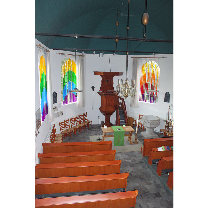
Scene Description: inside the new church; in the tradition of the Nederlands Hervormde Kerk, the font always close to the pulpit
Copyright Statement: Image copyright © Reliwiki, 2013
Image Source: digital photograph 2013 in Reliwiki [http://reliwiki.nl/index.php/Roderwolde,_Hoofdstraat_25_-_Jacobskerk] [accessed 4 February 2016]
Copyright Instructions: No known copyright restriction / Fair Dealing
design element - patterns - torsade
Copyright Statement: Image copyright © Protestantse gemeente te Roden-Roderwolde, 2016
Image Source: digital photograph in the Protestantse gemeente te Roden-Roderwolde [www.pkn-roden.nl/images/stories/Historie_kerken/jacobskerk/doopvont.jpg] [accessed 5 February 2016]
Copyright Instructions: No known copyright restriction / Fair Dealing
INFORMATION
Font ID: 20335ROD
Object Type: Baptismal Font1
Font Century and Period/Style: 15th - 16th century, Late Gothic
Church / Chapel Name: Nederlands Hervormde St. Jacobskerk Roderwolde
Font Location in Church: Inside the new church, at the E end of the nave, by the pulpit, S side
Church Patron Saint(s): St. James the Greater [aka James the Great, James the Elder]
Previous Font Location(s): originally from old St. Jacobskerk demolished 1830
Church Notes: original wooden church perhaps late-11thC; church here documented 1139; medieval church of brick demolished 1830; new church built 1831 using materials from the earlier church
Church Address: Hoofdstraat 25, 9315 PA Roderwolde (gem. Noordenveld, Drenthe), Netherlands
Site Location: Drenthe, Netherlands, Europe
Directions to Site: Located off the N372, in the municipality of Noordenveld, about 12 km SW of Groningen city centre
Additional Comments: disused font (for several centuries in the churchyard of the old church)
Font Notes:
Click to view
Baptismal font of Bentheim sandstone described (with old Dutch measurements) and illustrated in the Protestantse gemeente te Roden-Roderwolde [www.pkn-roden.nl/index.php/communicatie/elisabethbode?id=44&start=2] [accessed 5 February 2016]. The disused font was exiled to the churchyard of the old church during the Reformation; in time the population moved slowly south and the old church was too distant, so a new church was built in 1831 and the old one was demolished; the font was left in the old churchyard; eventually a shelter was specifically built for the old font in 1874 [cf. Images area]; the old font was spruced up and moved into the new church at a later date; it is now back to serving the church community. Translating from several sources [cf. infra] Pol Herman sent the following to BSI [e-mail of 8 November 2021]: "Jacobskerk, Hoofdstraat 25, 9315 PA Roderwolde, Nederland. Location : https://monumentenregister.cultureelerfgoed.nl/monumenten/32543. The first mention of the place is in 1139, as Roterwolde, and in 1350 already as Roderwolde. The place name indicates the fact that it was located in or near a forest area near Roden.
A special feature of Roderwolde is that the village has moved over the centuries. This can be seen from the site of the cemetery which is almost a kilometer outside the village. The church that was in the middle of the cemetery has been moved to the new center of Roderwolde. Old maps show that the village once surrounded this cemetery. The small white Jacobskerk was built in 1831. The old church near the cemetery at Pastorielaan, approximately 500 meters north of the current village, was then demolished. The stones of the medieval church were used for the construction of the pointed turret. Of the old church building, only the sandstone baptismal font from 1560, a church bell from 1634 and a church bell from 1651 have been preserved. Pol Herman
Attachments8 Nov 2021, 18:12 (16 hours ago)
to me
Roderwolde
Jacobskerk, Hoofdstraat 25, 9315 PA Roderwolde, Nederland
Location : https://monumentenregister.cultureelerfgoed.nl/monumenten/32543
The first mention of the place is in 1139, as Roterwolde, and in 1350 already as Roderwolde. The place name indicates the fact that it was located in or near a forest area near Roden.
A special feature of Roderwolde is that the village has moved over the centuries. This can be seen from the site of the cemetery which is almost a kilometer outside the village. The church that was in the middle of the cemetery has been moved to the new center of Roderwolde. Old maps show that the village once surrounded this cemetery.
The small white Jacobskerk was built in 1831. The old church near the cemetery at Pastorielaan, approximately 500 meters north of the current village, was then demolished. The stones of the medieval church were used for the construction of the pointed turret. Of the old church building, only the sandstone baptismal font from 1560, a church bell from 1634 and a church bell from 1651 have been preserved. In the church was a baptismal font of Bentheimer sandstone with a column high 13 palm, wide 9 palm and the basin 11 palm. G. de Leeuw and also R. Steensma claim that this font does not date from the Romanesque period, such as the fonts of Peize and Vries, but from the fifteenth century. The opinion of De Leeuw is based on the following characteristics: the decoration consists of two intertwined cables on the octagonal basin with a vertical thickening at the eight corners, from the cables to the bottom of the basin. The basin is entirely decorated with slanting parallel ledges and the column is extremely thin compared to Romanesque fonts. After the Reformation, the baptismal font was kept inside the church until the demolition of the church, against all ordinances of the Synod of Drenthe. Forty years later, the church board decided to place the font under a roof against the newly built morgue, at the entrance of the cemetery. Mr Boeles wrote a letter to the church council in 1874 to express his disapproval of the unworthy location of such an old monument in his opinion. Today, the baptismal font is back in the church as the only reminder of the pre-Reformation era. Source: Het kerkvoogdenboek van Roderwolde, 1538-1608, G. J. van Dijk-van Eerden, ISBN 90 232 3832 X. The bapstimal font is medieval and is made of Bentheimer sandstone. It is the only remnant of the Catholic worship in Roderwolde. Opinions differ about her exact age. Experts believe that it dates from the fifteenth century. But that seems to be mainly based on the thin pedestal – however it seems to be loose underneath and not to fit, so it could also be a replacement. Are those intertwined cables on the cockpit really romanesque? Romanesque or fifteenth-century, that makes a huge difference in the number of baptized children. In the first case there were thousands, in the second hundreds. With the Reformation, around 1600, it became zero, because then the font lost its function. But like all Drenthe, the Roderwoldigers valued antiques if they have a value, and the font therefore remained where it stood, despite the pious floaters who wanted to ban the thing from the church. The problem was: the village gradually moved. At the site of the original settlement, near the Romano-Gothic brick church, the ground level dropped and it became much wetter. The Roderwoldigers moved their new farms a little further south. On Sundays they would always sneaked back along the old and deserted path, to that little church. But they no longer had a good view on their church and they let it deteriorate. In 1828 the decision was made to build a new building near the new road. The old church would be demolished, and the turret of the new church would be built from the still usable material, which was completed in 1831. The baptismal font was left alone in the old cemetery. Only sheltered from wind and weather by trees. Until a morgue was built in 1874, and the church board decided to have a shelter built for the old baptismal font adjacent to that building. As on the postcard, judging by the type of letters on that card, it certainly stood there well into the twentieth century. Until it was time for her to be admitted to the new church, which was also quite old in the meantime. Since then, the morgue in the Roderwolde cemetery has had an empty shelter, which makes many visitors wonder what its function is. Source : Doopvont onder afdak, Drenthe vrogger, Groniganus, 2013". [cf. also BSI entry for Roden for the Bentheim font in Roden]
Credit and Acknowledgements: We are grateful to Pol Herman for his help in documenting this font
COORDINATES
UTM: 32U 330980 5893971
Latitude & Longitude (Decimal): 53.168227, 6.471394
Latitude & Longitude (DMS): 53° 10′ 5.62″ N, 6° 28′ 17.02″ E
MEDIUM AND MEASUREMENTS
Font Height (with Plinth): 124.8 - 130 cm*
Square Base Dimensions: 86.4 - 90 x 86.4 - 90 cm*
Trapezoidal Basin: 105.6 - 110 cm*
Notes on Measurements: * in Protestantse gemeente te Roden-Roderwolde [www.pkn-roden.nl] as: “met het voetstuk hoog 13 palm, het voetstuk breed 9 palm en de kom 11 palm” [NB: 'palm' assumed to be 'grote palm' = 9.6 cm or 10 cm]