Hien / Dodewaard / Hehun / Hia / Hijen / Hin / Hyen
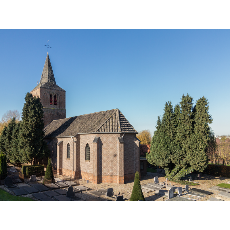
Image copyright © MichielverbeekNL, 2014
CC-BY-SA-3.0-NL
Results: 3 records
view of church exterior - southeast view
Copyright Statement: Image copyright © MichielverbeekNL, 2014
Image Source: digital photograph taken 24 November 2014 by MichielverbeekNL [https://commons.wikimedia.org/wiki/File:Hien,_de_Nederlands_Hervormde_Kerk_RM12931_foto7_2014-11-24_11.40.jpg] [accessed 26 December 2015]
Copyright Instructions: CC-BY-SA-3.0-NL
view of church exterior - southwest end
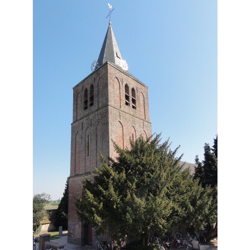
Copyright Statement: Image copyright © [in the public domain]
Image Source: digital photograph taken 25 April 2011 by Havang(nl) [https://commons.wikimedia.org/wiki/File:Dodewaard_Rijksmonument_12931_NH_kerk_Hien,_toren.JPG] [accessed 26 December 2015]
Copyright Instructions: CC-Zero
view of font - base - fragment
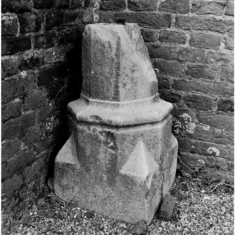
Copyright Statement: Image copyright © Rijksdienst voor het Cultureel Erfgoed, 2015
Image Source: B&W photograph taken April 1931 by Paul van Galen, in the Rijksdienst voor het Cultureel Erfgoed [https://commons.wikimedia.org/wiki/File:Voet_van_doopvont_-_Hien_-_20112592_-_RCE.jpg] [accessed 26 December 2015]
Copyright Instructions: CC-BY-SA-3.0-NL
INFORMATION
Font ID: 20262HIE
Object Type: Baptismal Font1, fragment
Font Century and Period/Style: 16th century[fragment], Late Medieval [composite]
Church / Chapel Name: Nederlands Hervormde Kerk te Hien
Font Location in Church: [cf. FontNotes]
Church Notes: chapel or church ca. 1050; independent parish 14thC; tower destroyed in fire 1641; re-built 1787; 1842 nave demolished but tower kept and new nave built -- The church is located on the Waalbandijk and has been privately owned since 2019. The last church service was held on November 4, 2018.
Church Address: Waalbandijk 95, Waalbandijk 95, 6669 ME te Dodewaard, Hien, Netherlands
Site Location: Gelderland, Netherlands, Europe
Directions to Site: Located off road 36 and the A15, just SE of Dodewaard, in the municipality of Neder-Betuwe
Font Notes:
Click to view
Reported in De Hervormde Gemeente van Hien en Dodewaard [www.hervormddodewaard.nl/historie] [accessed 26 December 2015] as a fragment of the base of a font or stoup found in the churchyard, 70 cm high and probably 16th-century; it is the lower part of an octagonal pedestal decorated with a moulding, and with the breach stops that make the lower base square, typical of late medieval fonts in the area; this same source notes that the fragment was planned to be incorporated into a reconstructed font in the restoration of the church in the 1980s [NB; not known whether or not the plan was carried out -- The Dutch Wikipedia entry for this church [https://nl.wikipedia.org/wiki/Hervormde_kerk_(Hien)] [accessed 5 October 2025] reporta the 16th-century font in the churchyard: "en het 16e-eeuwse doopvont. Die laatste ligt overigens op het kerkhof."] The font is listed in the Rijksmonumentenregister
[https://monumentenregister.cultureelerfgoed.nl/monumenten/12930] [accessed 5 October 2025]: "De vm. Herv. Kerk van Hien. In het kerkinterieur onder andere vier kronen, 17e eeuw; kaarsenhouder aan de preekstoel 17e eeuw, op het kerkhof, een 16e eeuwse doopvont."
[https://monumentenregister.cultureelerfgoed.nl/monumenten/12930] [accessed 5 October 2025]: "De vm. Herv. Kerk van Hien. In het kerkinterieur onder andere vier kronen, 17e eeuw; kaarsenhouder aan de preekstoel 17e eeuw, op het kerkhof, een 16e eeuwse doopvont."
COORDINATES
UTM: 31U 683454 5754176
Latitude & Longitude (Decimal): 51.90808, 5.667064
Latitude & Longitude (DMS): 51° 54′ 29.09″ N, 5° 40′ 1.43″ E
MEDIUM AND MEASUREMENTS
Material: stone, limestone