Lower Dunsforth / Dunesforde / Lower Dunsforth
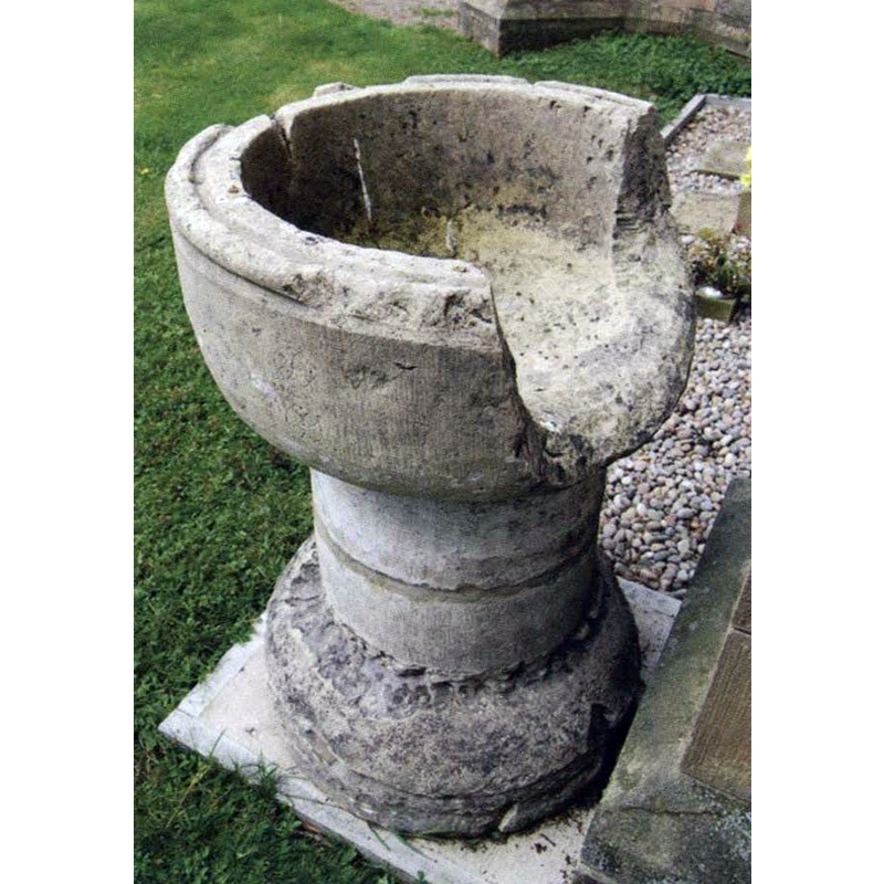
Image copyright © The Dunsforths Villages, 2015
No known copyright restriction / Fair Dealing
Results: 4 records
view of font
Scene Description: the disused font; although described locally as a "Saxon font" it is more likely well into the Gothic period [cf. FontNotes]
Copyright Statement: Image copyright © The Dunsforths Villages, 2015
Image Source: digital photograph in The Dunsforths Villages [www.dunsforths.co.uk/information/st-marys-church] [accessed 11 November 2015]
Copyright Instructions: No known copyright restriction / Fair Dealing
view of church exterior - portal - detail
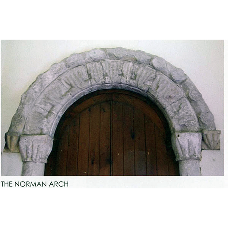
Scene Description: part of the Norman portal of the medieval chapel-of-ease re-built into the vestry of the Victorian church
Copyright Statement: Image copyright © The Dunsforths Villages, 2015
Image Source: digital photograph in The Dunsforths Villages [www.dunsforths.co.uk/information/st-marys-church] [accessed 11 November 2015]
Copyright Instructions: No known copyright restriction / Fair Dealing
view of church exterior - southwest view
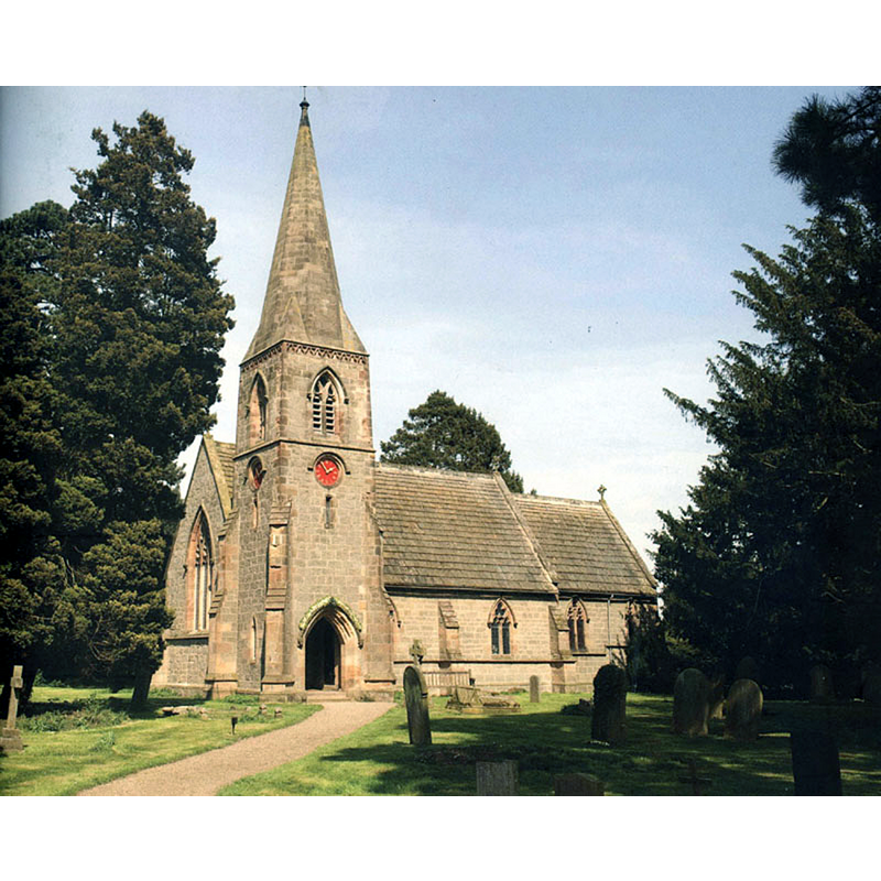
Scene Description: the mid-19thC replacement church
Copyright Statement: Image copyright © The Dunsforths Villages, 2015
Image Source: digital photograph in The Dunsforths Villages [www.dunsforths.co.uk/information/st-marys-church] [accessed 11 November 2015]
Copyright Instructions: No known copyright restriction / Fair Dealing
view of church exterior - southeast view
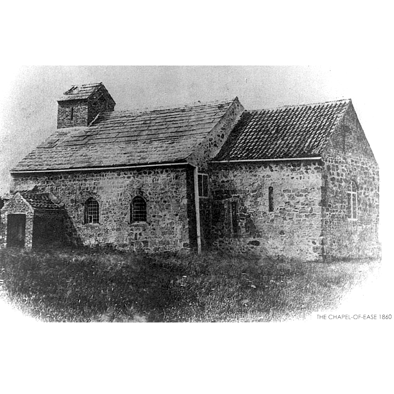
Scene Description: the medieval chapel of ease in 1860, just before its demolition
Copyright Statement: Image copyright © The Dunsforths Villages, 2015
Image Source: digital image of a photograph in The Dunsforths Villages [www.dunsforths.co.uk/information/st-marys-church] [accessed 11 November 2015]
Copyright Instructions: No known copyright restriction / Fair Dealing
INFORMATION
Font ID: 20112DUN
Object Type: Baptismal Font1
Font Century and Period/Style: 14th - 15th century, Gothic
Church / Chapel Name: Parish Church of St. Mary [from the old demolished church]
Font Location in Church: Inside the new church
Church Patron Saint(s): St. Mary the Virgin
Church Notes: present church 1860 replaced a medieval one here
Church Address: Lower Dunsforth, Boroughbridge, North Yorkshire, YO26 9SA
Site Location: North Yorkshire, Yorkshire and the Humber, England, United Kingdom
Directions to Site: Located between Aldborough and Great Ouseburn (to the S), ENE of Harrowgate, WNW of York
Ecclesiastic Region: Diocese of West Yorkshire and the Dales [formerly in the Diocese of Ripon]
Historical Region: formerly in the West Riding of Yorkshire -- Hundred of Burghshire [in Domesday]
Additional Comments: disused font / damaged font [cf. FontNotes]
Font Notes:
Click to view
There are two entries for [Lower and Upper] Dunsford [variant spelling] in the Domesday survey [http://opendomesday.org/place/XX0000/lower-and-upper-dunsforth/] [accessed 13 November 2015], neither of which mentions cleric or church in it. The Dunsforths Villages [www.dunsforths.co.uk/information/st-marys-church] [accessed 11 November 2015] informs: "In 1853 the old Chapel-of-Ease was described as: "A primitive and basic structure consisting merely of a nave and chancel with a brick bell turret about two yards square, perched like a pigeon house upon the west end; it is a wretched building in the old barn style of architecture." In 1859 an architect's report recommended the demolition of the old chapel and authorisation to do this was obtained from the Bishop of Ripon in May 1860. Inevitably regrets were expressed that attempts were not made to restore the old building, (there is a suggestion that both Revd. Sykes and Mr. A.S. Lawson would have liked it to be preserved) but it was finally agreed that a new church should be built. [...] The new church stands on the same site as the ancient chapel and was dedicated in 1861. [...] Re-built within the vestry of the present church stands a Norman arch. This is thought originally to have been the inner doorway of the chapel. [...] The only other relic of the Chapel-of-Ease is the Saxon font, which is badly broken. The damage is so severe that there is a suggestion that it was caused deliberately, possibly during the Reformation when the chapel, like other churches in the area, was vandalised and burnt and the font probably thereafter lay un-used for years. The records show that among the baptisms in the parish many were of children born to families working the barges that thronged the River Ure. There was a tradition in the villages of baptisms being conducted at home, which may have developed because there was no font in the chapel. Certainly Revd. Sykes had some difficulty persuading the congregation to have their children baptised during services in the new Victorian font." The preserved font is not Saxon, and is probably not the original font from the Norman church demolished in 1860; it consists of a round, almost hemispherical basin with a roll moulding at the upper rim, otherwise plain; raised on a plain cylindrical pedestal base and a splaying circular lower base, noth plain. Contrary to the statement above, the font most likely broke by itself (e.g., water left in the basin froze and split the basin), or due to an accident; it could even have been broken on purpose if, once the font became disused, it was put to other uses, like serving as a rain-water catch against a wall, hence the damage pattern. It is of later date than the original church, probably late-13th or 14th century. The present font is Victorian, probably from the 1860 replacement church here.
COORDINATES
UTM: 30U 609624 5993482
Latitude & Longitude (Decimal): 54.077856, -1.324419
Latitude & Longitude (DMS): 54° 4′ 40.28″ N, 1° 19′ 27.91″ W
MEDIUM AND MEASUREMENTS
Material: stone
Font Shape: hemispheric, mounted
Basin Interior Shape: round
Basin Exterior Shape: round
Drainage System: centre hole in basin
Drainage Notes: no lining